

This picture is a view from the north of a bridge called Sinmachi Bridge, which was located in front of the current Tennocho Station on the Sotetsu Line.
The distance from Kanagawa-juku to Hodogaya-juku is about 5 km, but this is the distance between the honjin, so the distance from Daimachi, which was painted in Kanagawa-juku last time, to this Sinmachi bridge was only about 3 km.
Coming down the Tokaido from Daimachi, the road becomes a main street as it passes under the Metropolitan Expressway, and then turns into a path again at the Sengen-shita intersection. At that time, the Sengen Shrine on the right side of the path served as a guide for travelers on the Tokaido.
A little further down the road, there is a fork in the road with Hachioji-michi, and going to the right, one could go to Hachioji or Oyama. After crossing the dividing line, the Tokaido becomes the Matsubara shopping street. The official name of this shopping street is “Koufukuji Matsubara Shopping Street,” which is the most famous shopping street in Kanagawa Prefecture.
Continuing through that shopping street and over Route 16, you will see Tachibana Shrine on the right. Further on, crossing the present-day Katabira Bridge, the Tokaido will abruptly pass under Tennocho Station.
Turning around from in front of the station, one can see the Katabira bridge is slightly elevated and the shopping street continues all the way to the end of the bridge.
From Tennocho station platform, you can clearly see that the shopping area extends much farther.
This is a view of the south side of Tennocho Station from the platform. After crossing the reconstructed old Katabira bridge, the train curves gently to the left, merges with the main street, Loop Route 1, and heads south in an almost straight line for about 1.3 km.
The three towns beyond the old Katabira bridge were called Shinmachi because they were new towns created when the Tokaido was laid out in 1648, and the old Katabira bridge was also called Shinmachi Bridge.
At the end of this shinmachi, around what is now JR Hodogaya Station, there was a Toiyaba, and beyond that, at Oiwake, turning left was the Kanazawa-Uraga-Michi, which led to Kanazawa and Uraga via Gumyoji. The road was then straight ahead and went straight to Hodogaya Station. Going straight ahead, we came to the Honjin of Hodogaya-juku.
To see the change of the Katabira river and the Shinmachi bridge, look at the GSI’s map of the Tennocho area.
On the map, draw the Tokaido and cover it with the map of 1881.
In the Edo period, the Tokaido came from the north side, and at the Katabira River, it became slightly cranked and went in the same direction again. However, in 1956, the river line of the Katabira River was replaced from the south side of Tennocho Station to the north side, and the Katabira Bridge was accordingly relocated and became the current concrete bridge.
In 1964, the bridge that stood before the renovation was restored as a monument in the current Tennocho Ekimae Park.
We will return to the modern map and include Hiroshige’s viewpoint in a red gradient.
Let’s take a closer look at Hiroshige’s painting.
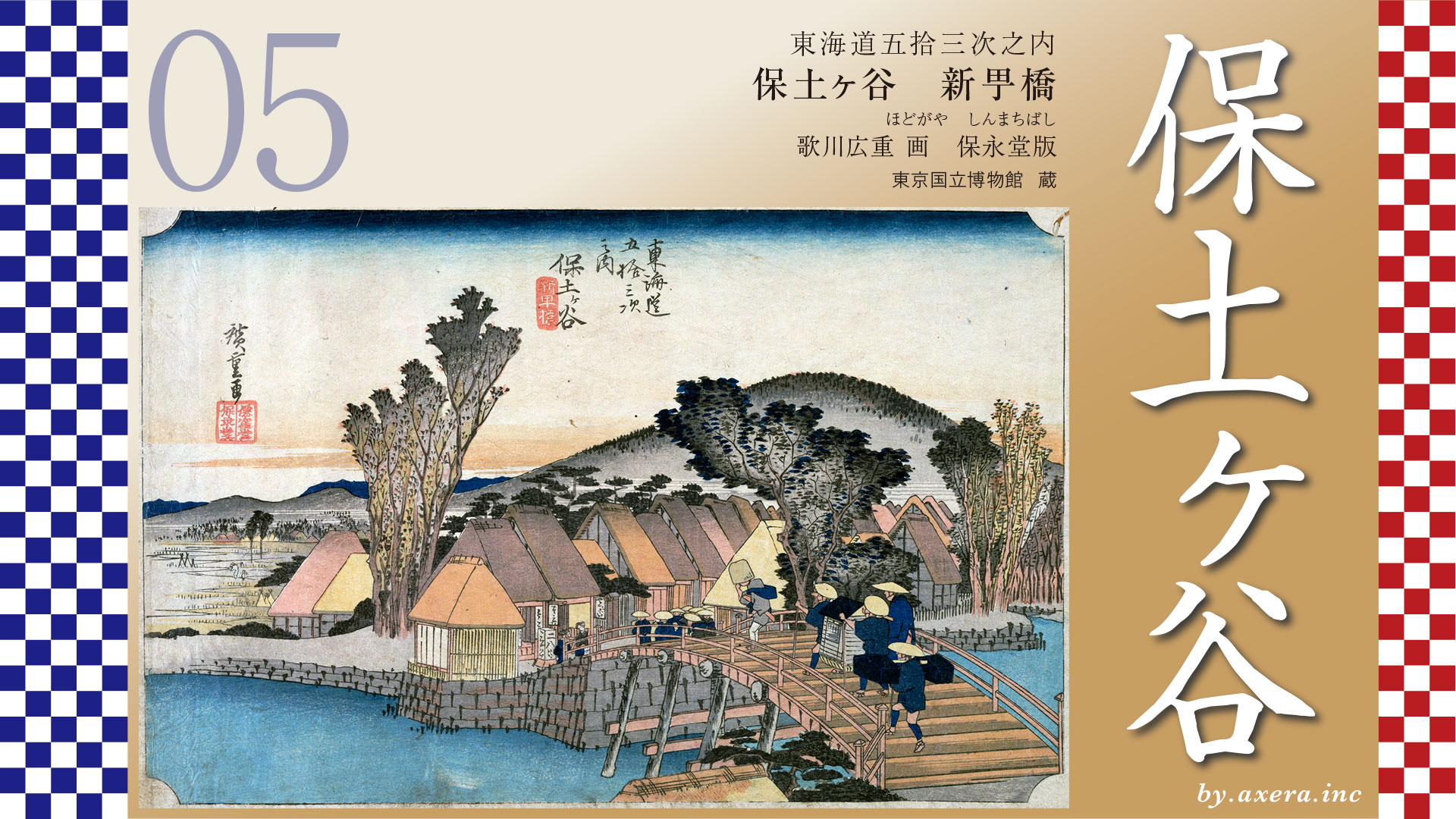
Crossing the bridge are a komuso monk in a deep braided hat, a samurai in a palanquin, and his retainers and attendants, and coming from the opposite bank is a group of samurai wearing Sugegasa hats. The restaurant across the bridge, where two women are standing, is a buckwheat noodle shop, which can be recognized by the sign “Nihachi. It seems from other travelogues that a buckwheat noodle shop actually existed here as well as a resting place.
The left side of the painting is the east side of Tokaido, with a peaceful rural landscape, but now it is around Nishikubo-cho, where the JR line and National Route 1 are busy. The mountains ahead on the right are thought to be Nagata to Kariba mountains. Also, according to records, the bridge at that time was 27m long and 5.4m wide, so it looks a little smaller.
This painting is close to the first print, but it is a bit damaged.
Since we are here, please take a look at the second print, which is in good condition. The difference between the first print and the second print is that the blurring has been removed from the mountainside and the roof of the house in the background, giving the whole image a lighter, lighter look.
This is the Edo Meisho Zue, which Hiroshige is said to have used as a reference. This is the view from Hodogaya-juku side. The buckwheat noodle shop on the lower left was used as a rest stop on the Shinmachi side. You can see “Nihachi” written on it. This bridge seems to reflect its actual size.
This is a photo of Shinmachi Bridge taken around 1918 from the same angle as Hiroshige. Until this time, the Shinmachi Bridge seemed to be in almost the same condition as it was at the time of Hiroshige.
The Reisho edition is a snowy scene with the bridge almost in front of it. The bridge is drawn long, and a traveler wearing a straw hat, a coat, and a roadside coat walks along the bridge in the cold.
The Gyosho edition depicts a traveler relaxing on a pier behind a buckwheat noodle shop. On the bridge, a palanquin carrier and a peddler are about to pass each other. The colors suggest a scene of fresh greenery.
The Poem edition the situation at Sakaigi Tatebana, located almost at the end of Hodogaya-juku and up the Gonta-zaka hill. The stand is a resting place for travelers, but it has a great view and is a perfect place to stop at a teahouse, which was very crowded. A little further on, there was also the Sakaigi Jizo, which is beneficial for good luck with money.
Please look at the wide-area map again. According to the official record of the Shogunate, Hodogaya-juku was the light blue dashed line from the green ball in the upper right corner, around junction on the Hachioji-michi road, to the position of Sakaigi at the top of Gonta-zaka hill. The distance was about 5 kilometers, indicating that it was a very long Shuku. As the name suggests, Sakaigi was also the border between Sagami-Province and Musashi-Province.
I have actually been here. This place is now a park in front of Tenno-cho Station, the river is gone, and the bridge is just a boarded-up sidewalk. It is somewhat difficult to call it a bridge, but there is no doubt that Hiroshige painted this location.
Katsushika Hokusai painted Hodogaya in his Thirty-six views of Mt. Fuji. This is the view from the Sakaigi or Yakimochi-zaka area at the top of Gonta-zaka Hill. You can imagine how good the view was from this area.
Hiroshige also painted Sakaigi in his Poem edition, but in the Hoei-do edition, the first in the series, he avoided the famous place and chose Shinmachi bridge, the eastern entrance to Hodogaya-juku, as the motif of his painting.
In fact, at that time, towns written as “shin,” or with the “shin” in the name, inevitably had a glossy sound. Shin-Yoshihara and Naito-Shinjuku in Edo and Kachi-Shinjuku in Shinagawa, for example, and in Osaka, it was Shinmachi prostitute, famous for its yugiri tayu. Naturally, there were also inns in Shinmachi in Hodogaya-juku, and many unauthorized prostitutes called “meshimori-onna.
At that time, it was natural for inns to have a woman who served as a prostitute in the inns, and the existence of prostitutes as a profession itself was a common part of the culture.
Hiroshige intentionally painted the Katabira bridge to stir up the traveler’s mood in this spacious Hodogaya juku, abandoning the Sakaigi, which had a good view of the city. He also named the bridge after the name of the Shinmachi, which sounds like “romantic”. The now-famous shopping district of Koufukuji Matsubara is said to have begun when the area around Koufukuji Temple, which had been burned down after the war, became a red-light district.
Please take a look at the GoogleMAP Street View looking ahead from the Shinmachi Bridge area.
In the front, you can see the mountains of Hakone, and Mt.Fuji.
The Tokaido Highway drawn in orange is almost completely in the Hodogaya-juku area. This shows how long Hodogaya-juku was.
After passing the Hodogaya-juku honjin, the Tokaido ascends Gonta-zaka Hill and passes through the east side of Higashi-Totsuka station from around Sakaigi, which offers a fine view, to Totsuka-juku.

コメント