

This painting depicts an inn located near the entrance to Totsuka-juku, by the Yoshida Bridge.
The distance between Hodogaya-juku and Totsuka-juku is approximately 8.8 km.
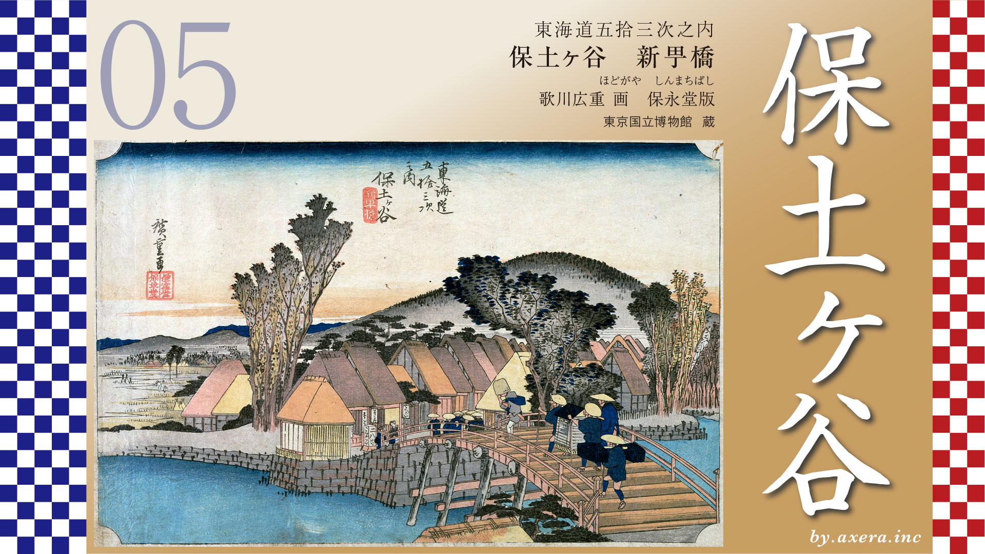
Hodogaya-juku follows National Route 1 for a while, then turns off to the right just before Kariba and goes up Gonta-zaka, a small hill.
This Gonta-zaka is a very scenic place, and the best view of the Kanagawa Sea from Sakaigi at the top is acclaimed in the Fudoki and travelogues.
After passing Gonta-zaka, you will cross “Sakaigi-tateba” and go down Yakimochi-zaka hill to cross Shinano Ichirizuka. From there, the road climbs a little more, and at its highest point, a pedestrian bridge crosses over the four-lane road that is now Yokohama Loop Road No. 2.
After crossing the pedestrian bridge, you will descend the long, long Shinano slope and head toward Route 1.
After merging with National Route 1 and continuing along with the railroad tracks, the road comes to a fork with Oyama Road. If you go to the right, you can go through Chogo and Yoda to Isehara, but now there is an overpass to first cross the JR tracks.
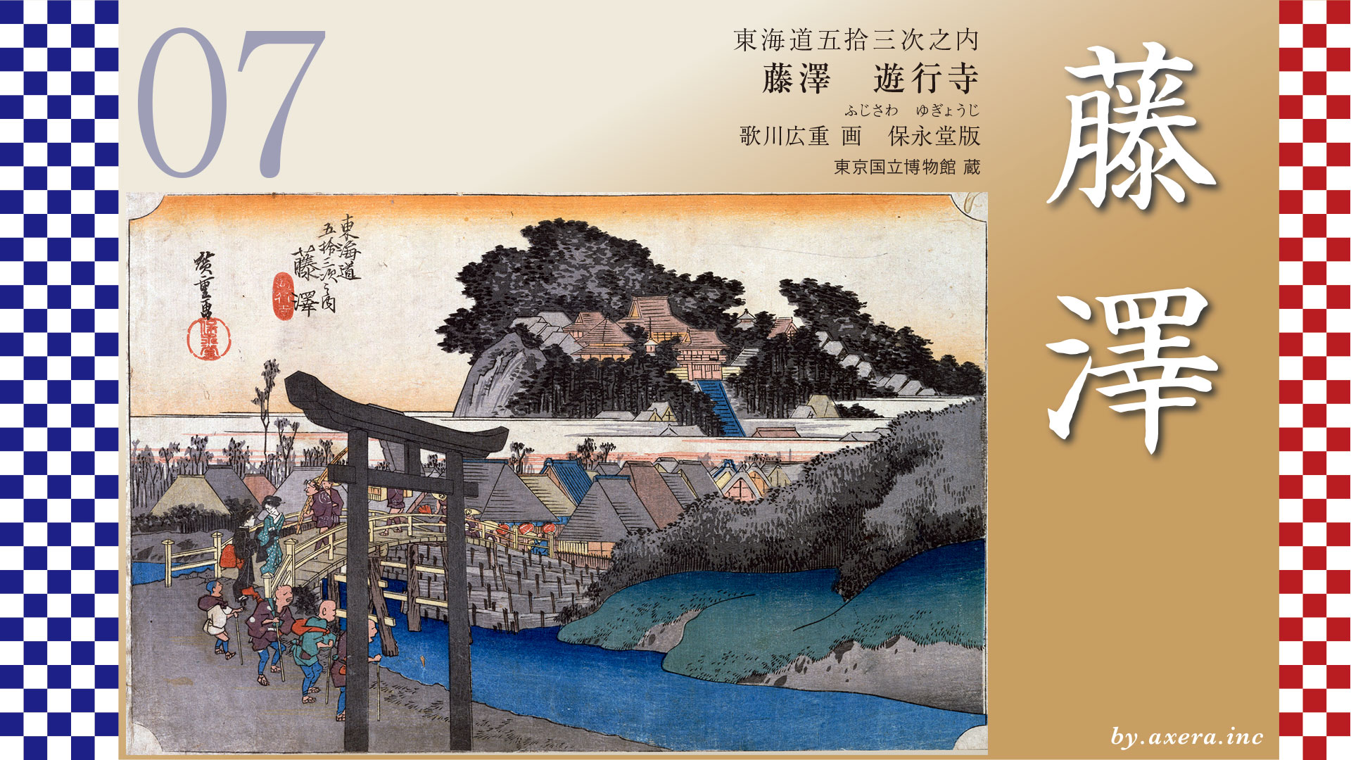
Eventually, as the Tokaido passes the sprawling Bridgestone Yokohama Plant, it meets the Kashio River at the eastern end of Totsuka-juku, with Edo-mitsuke on the side. The Yoshida Ohashi Bridge here is the view of Totsuka-juku painted by Hiroshige.
This bridge also serves as a junction with the Kamakura-michi, and if you go left, you can go to Kasama and Ofuna, and then to Kenchoji Temple in Kamakura.
Cross the bridge and turn left, and you will come to Totsuka Station, but before that you will see the Toiyaba of Totsuka-juku. Nowadays, you cannot go on foot beyond this point, and must cross the railroad tracks by elevator and pedestrian bridge.
After crossing the railroad tracks, the road merges with Route 1 again and heads in the direction of Fujisawa-juku, past the two honjin and waki-honjin of Totsuka-juku.
Please see the map of the wide area from Nihonbashi. The distance from the Nihonbashi Station to the Totsuka Station was about 40 kilometers from Edo, and it was said to be just before sunset around Totsuka if one left the station before 4:00 a.m., which is before dawn. In the Edo period, people in Edo were so physically fit that they could walk this distance in a day.
Now look at the map overlooking the area from Hodogaya to Fujisawa.
From Hodogaya, Fujisawa-juku was about 14 km away, and Totsuka-juku was right in the middle of it.
Totsuka-juku was about 2.2 km long, with a population of about 3,000, 600 private homes and 70 inns, making it a little small, but it was the second largest juku in Sagami after Odawara. In the beginning, however, it was treated as a stopover until this long Fujisawa-juku. It was also surrounded by steep hills from north to south, and was a follower of the Kamakura Road.
Furthermore, it was also a place that could be reached just in the evening after a day’s walk from Edo, and for these reasons, the number of inns gradually increased. While the Fujisawa and Hodogaya juku were established in 1601, the Totsuka juku belatedly became the fifth juku officially recognized by the shogunate three years later, in 1604.
This was reportedly opposed by the Fujisawa-juku, which feared losing customers at the time. You can see how much of an economic impact the lodging of travelers had at the time. Please take a look at this interesting Ukiyoe by Hiroshige, which depicts such an exchange and the journey from Totsuka to Fujisawa.
If you look closely at Hiroshige’s painting, you will see that the sky is red and the distant scenery is a little darker, just as the sun is setting. The woman in the center of the scene is holding a walking stick and trying to remove her straw hat as if to say, “I have finally arrived. Beside her, a traveler is trying to get down from his horse, using a tea stall’s bench as a good place to do so. This horse was called a karajiri-uma, a means of transportation in the Edo period, in which a person and his or her luggage were carried on a horse for a fee. It is quite humorous that the horseman holds the reins of the horse and looks at the traveler, who is in the form of a monk, coming across the bridge. Perhaps he is thinking of taking this traveler as a guest on his return trip.
On the eaves of the inn marked “Komeya” , there are many wooden plaques of Oyama-Ko and other-Ko groups. It seems to have been a very prosperous inn that was often used by groups of visitors on pilgrimages to Oyama or on visits to Ise. However, the innkeeper, who was about to fall down from her horse, kept her left hand in her pocket, as if not willing to lend a hand to a guest who was getting off her horse. Perhaps it is because she is a private guest, but this is interesting. In front of this bridge stands a lantern, under which you can see a stone pillar with a signpost “Left kamakura-michi”.
What you see beyond the inn is the current Totsuka-cho mountain, which leads to the Totsuka Police mountain, famous for the hill climb in the Hakone Ekiden. The rice paddies in the foreground are around present-day Totsuka Station, where there is a forest of tall buildings.
This painting is almost a first print, but there is a other edition of this Totsuka painting.
The other edition is more like night than evening throughout, and the traveler, who had dismounted from his horse in the first slide, is about to mount his horse. The mountain that was visible at the far left is gone, and a wall with vertical latticework has been created in the inn. The roofs of the houses are also white, as if they had been left unpainted.
The Reisho edition depicts a steep slope lined with pine and maple trees called Oosaka, located at the west end of Totsuka-juku, just beyond Kamigata-mitsuke. From the top of the hill, one can see a beautiful view of Mt.Fuji.
The gyosho edition is a picture looking down on the Totsuka-juku from the top of the hill. This is the area to the east of the current Totsuka Police Station. The mountains in the background are the Tomitsuka tumulus and Tomizuka Hachiman Shrine, which gave Totsuka its name.
The poem edition is a picture looking at Totsuka-juku from around Kamigata-mitsuke, the end of the juku. This is the area where the steep hill has already been descended.
When I actually went here, I found that the “Komeya” inn had disappeared and was replaced by a parking lot. Yoshida Bridge has been renamed Yoshida Ohashi Bridge and is now a two-lane road with sidewalks on both sides. After crossing the bridge, this road passes under the JR tracks in a tunnel. Tokaido takes the left side of the road, curving to the right and ending at JR Totsuka Station.
I came a little closer to an angle closer to Hiroshige’s painting. If you go to the left before this bridge, you will reach Kamakura-michi, which still follows the Kashio River to Ofuna.
This is the view of the road to Kamakura after turning left.
This is the view from the bridge looking toward Hodogaya. In spring, this Kashio River is lined with cherry blossoms, making it a very beautiful place for citizens to relax.
This is Yoshida Bridge from a book published in 1918. Although there are no lanterns or road signs, it seems that at this time, the world that Hiroshige depicted remained almost exactly as it was.
This is a view of Osaka from the Kyogata-mitsuke area as depicted in the reisho editions, gyosho editions, and poem editions. The slope is now broken up and gently sloping, but in the Edo period it was a long, steep ascent with pine trees on the left and maple trees on the right.
This is a view of Yoshida Ohashi Bridge from above, using GoogleMAP’s Street View. The Tokaido is depicted in orange. The area where the orange color disappears is where the hill used to be steep, and the Totsuka Police Station, famous for the Hakone Ekiden, is now on the right side of the hill.
The Tokaido continues to the east of the Totsuka Police Station, passing over the villages of Harajuku and Kagetori, and heading toward Enoshima as it heads toward Fujisawa-juku.
コメント