
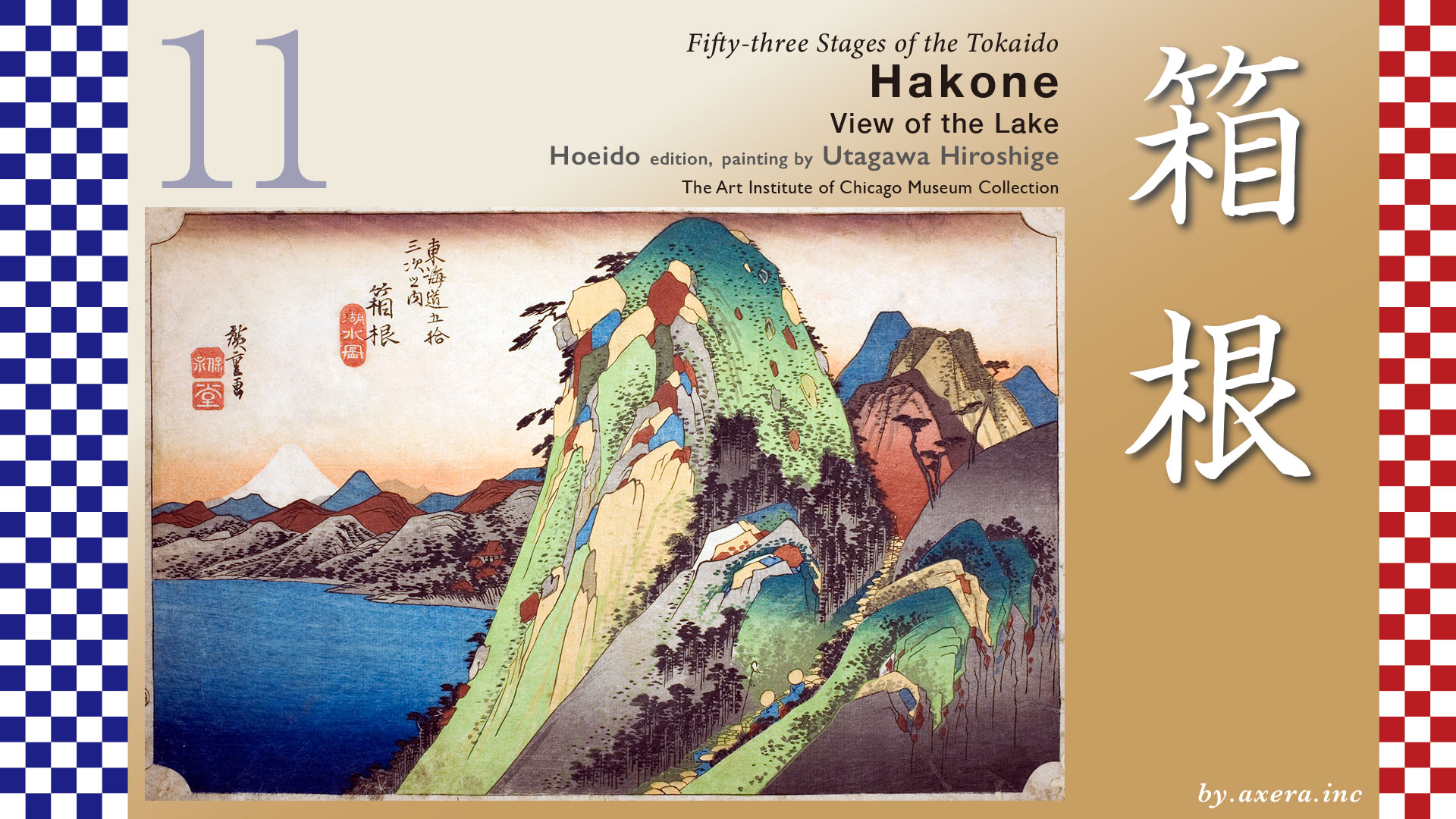
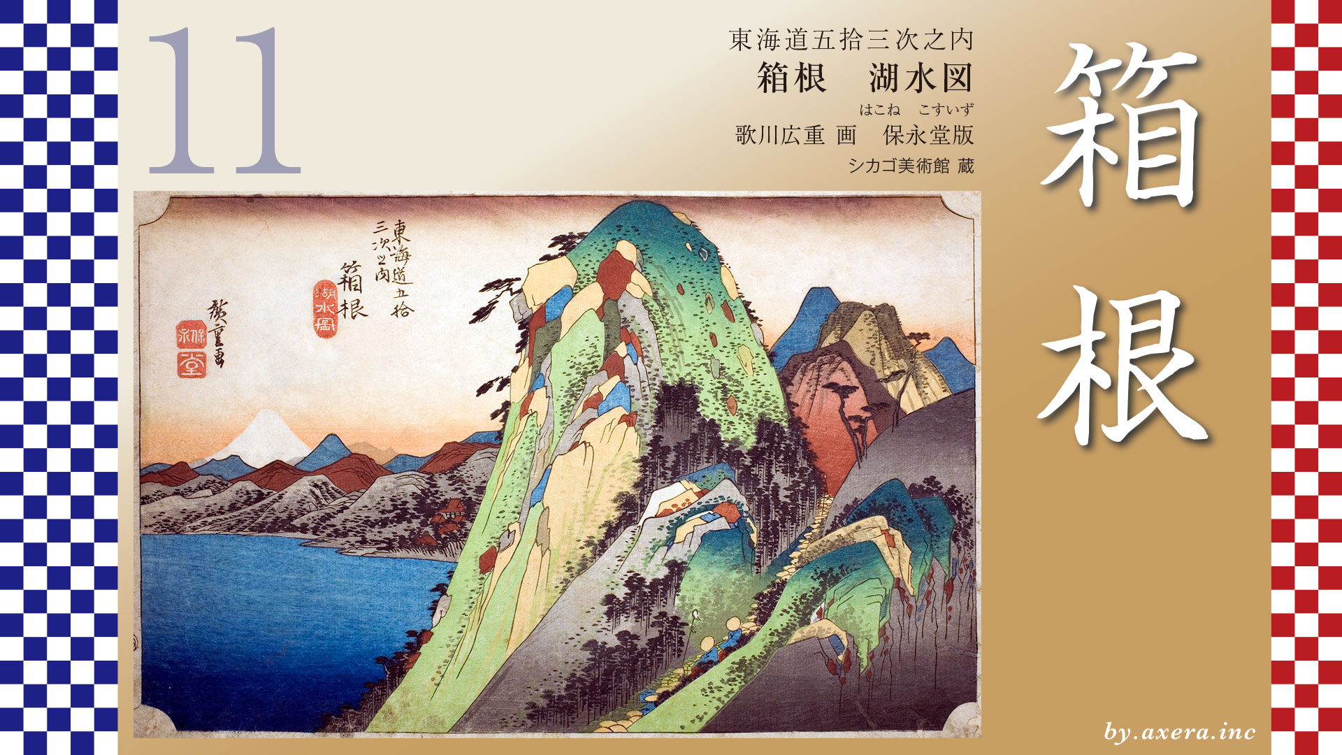
Speaking of Hakone, this painting has been cited many times in various places and has become synonymous with the difficult Hakone area. It depicts the mountains of Hakone, Lake Ashinoko on the left, and Mt.Fuji.
Hakone-juku is less than 17 km from Odawara-juku, but there is a difference in elevation of about 800 m, 90% of which is uphill, and from Yumoto it is a breathtaking ascent.
This is a view toward Hakone as seen from Odawara Castle keep. The mountain in front is Komagatake, which Hiroshige depicted as if it were looming up in his painting of the Hakone “View of the Lake”. If you look closely, you can also see the top station of the ropeway. It makes you feel as if you are going up to the top of the mountain.
The Tokaido runs westward along the left bank of the Hayakawa River from Odawara-juku to Hakone-Yumoto. On the way, it turns into a small road around the Odawara-Atsugi Road and crosses Kazamatsuri no Ichirizuka.
The Tokaido joins Route 1 again, and just before Hakone-Yumoto Station, crosses a bridge, crosses the Hayakawa River, and enters the town of Yumoto. From here, the road becomes a real slope.
From the Hakone Chaya area, there are fewer houses and the road becomes more mountainous.
The Tokaido becomes a full-fledged stone-paved road from around Hakone Ichirizuka, after crossing Hatajuku, which is resting place between inn towns.
Passing behind the famous Amazake-chaya teahouse and up Otama-zaka, the road bids farewell to the Route 1 roadway and enters the authentic old The Tokaido, which is now a hiking course.
By the time the Tokaido intersects with Route 1 again, it is downhill, and the area ahead is the setting for Hiroshige’s View of the Lake.
In this area, you can still experience The Tokaido made of stone like this.
Once on the shores of Lake Ashinoko, The Tokaido turns southward, passing through a line of cedar trees that still remain and over a low hill to the entrance to the Hakone barrier.
Today, the gate has been restored and is now a tourist attraction.
The Hakone barrier for the defense of Edo had a strict surveillance system, symbolized by the phrase “entering guns and exiting women, but compared to the Arai barrier, the Hakone barrier was relatively loose.
The Hakone barrier is entered through this entrance, and if you go straight to the left, you will reach the center of Hakone-juku, where the Honjin was located. Nowadays, it is more famous as the goal of the outward leg of the Hakone Ekiden race.
Here, please see the “Rekichizu” which describes the road at that time. In this area, there were 6 barrier stations including Nebukawa, Sengokubara, and Yagurazawa, centering on the Hakone barrier station. These are the red triangles on the map. This shows that there were various roads from the east to the west other than The Tokaido.
In fact, most of the tales, travelogues, and waka poems of the Heian period record the crossing of Ashigara-michi, which is now Route 246, and the crossing of Hakone, as we know it today, was extremely rare. The green line is Ashigara-michi.
Fuji erupted, the course that followed the current ekiden course from Tonozawa up via Ashinoyu or from Yumoto up to Lake Ashinoko became mainstream, and Hakone-juku on the southern shore of Lake Ashinoko began to flourish greatly. The Tokaido in navy blue.
The opening of hot springs in Hakone dates back to the Nara period, but before the Edo period, the main purpose of hot springs was to heal the wounds of samurai and other warriors. However, with the opening of The Tokaido, Hakone’s hot springs suddenly came into the limelight as a tourist destination. The seven Hakone hot springs were especially popular, and Hiroshige included them in his “Hakone Shichito Zue, a series of seven paintings. During the reigns of Tokugawa Iemitsu and Tokugawa Tsunayoshi, Hakone’s hot springs were often used as a gift to the shogun.
Hakone Shichito refers to the seven hot springs in Hakone that have come into the limelight.
Two of Hakone Shichito are also listed as Maegashira in the hot spring ranking list at that time. These are the hot springs surrounded by this red frame. Ashinoyu and Yumoto were quite popular at that time. By the way, this hot spring ranking is very interesting, isn’t it?
Please see the picture drawn as a bird’s-eye view of this area written in the Edo period. Hakone Shrine is on the left, Hakone-juku is at the upper right edge, and the dark blue road is The Tokaido.
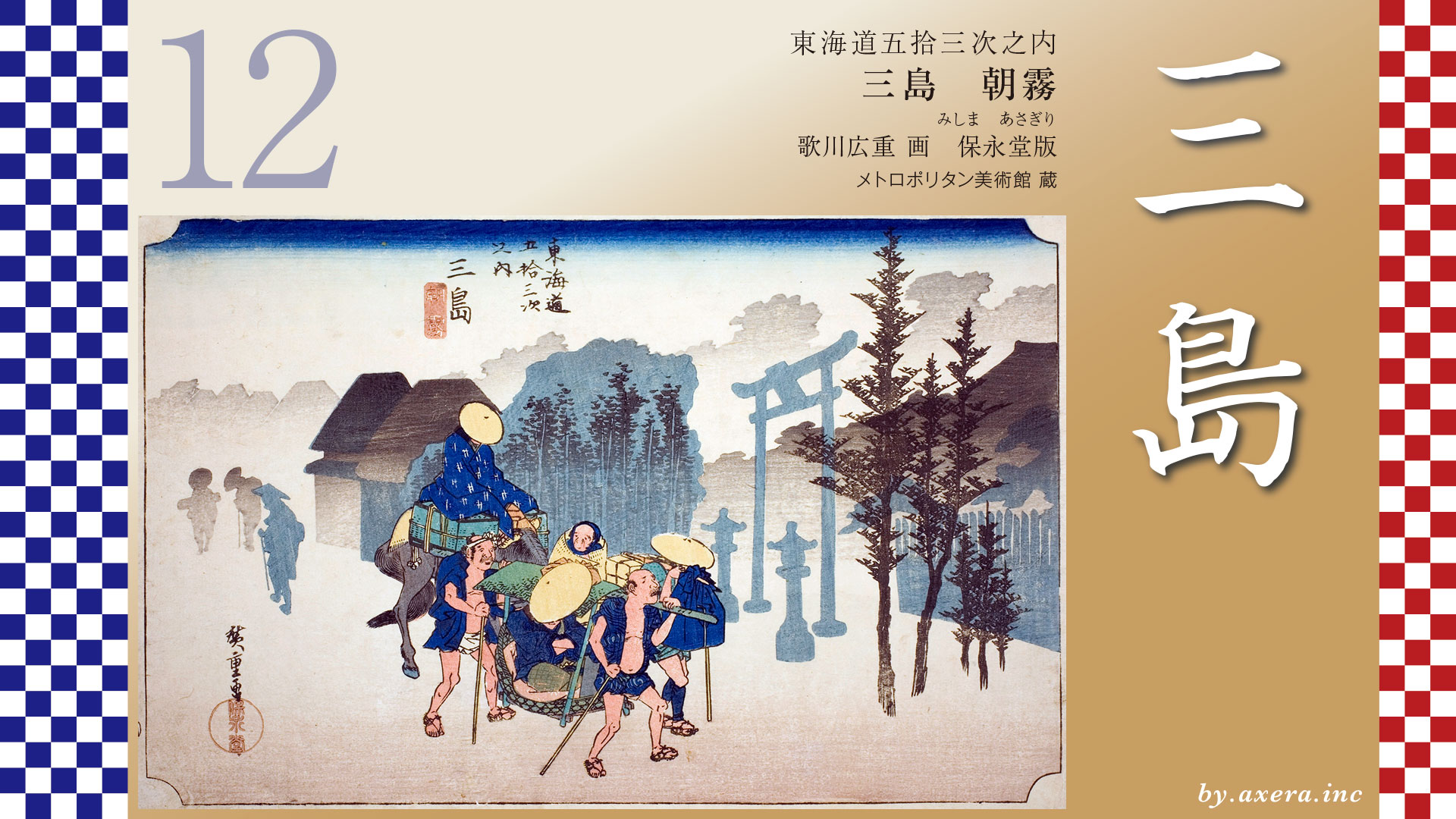
In the Edo period, the new The Tokaido was officially established in 1604, and Hakone-juku became a major development. In fact, The Tokaido is said to have been routed with steep Mt. Hakone as the keystone of Edo’s defense, with the west slope on the Mishima side being a ridge road where enemies could be easily detected, and the east slope on the Odawara side being a valley route where outside enemies could be easily intercepted.
Please take a look at Hakone-juku as seen from Hakone Pass, taken around 1880. Hakone-juku is said to have had 2 Toiyaba, 6 Honjin, 1 Waki-honjin, and 36 inns in the late Edo period. This prosperity was due in part to the fact that feudal lords had no choice but to pass through this area because it was a public road in the Edo period.
However, once it rained or snowed, travelers found it very difficult to walk this route as they would get muddy up to their shins. In 1680, the Tokugawa Shogunate therefore spent over 1,400 ryo of public funds to create a 10-km stone-paved path from the Hakone Pass to the Mishima-juku.
Although the details of the cobblestone path from Hakone Pass to Odawara-juku, which remains today, are not known, it is said that this path was also constructed at the same time.
Let us look at the actual painting by Hiroshige.
The colorful mountain in the middle is said to be Hakone, and probably Komagatake, which he painted with considerable emphasis.
Fuji is depicted in white on the left, and Lake Ashinoko is depicted below it in dark blue. The Hakone Shrine is depicted at the right edge of the lake, and Moto-Hakone is a little before this point.
The mountains in the foreground are a procession of feudal lords coming from Edo, and it is said that this road is The Tokaido, and the brown mountains at the far end may be Futagoyama.
I like this painting the best of the series. What is interesting is that Hiroshige has placed a cubist-style mountain in the middle, which is not even high enough to be there, and balanced it throughout. And yet it is complete as a painting, which is wonderful.
The Reisho edition depicts a traveler carrying a torch up the dimly lit cobblestone streets of The Tokaido. It seems that crossing Hakone at night was an actual practice.
The Gosho edition depicts travelers approaching the Hakone Pass. Two people carrying a balance pole are coming up from the Mishima side. On the right side, a stick-shaped guide board indicating the border is also depicted.
Poem editin depicts two groups of travelers on palanquins following a leader with a torch. It seems as if we can hear them calling out “Essa, hoisa” at any moment.
Hokusai also painted Mt. Fuji in his Thirty-six views of Mt. Fuji, under the title Lakes. Fuji and Lake Ashinoko, Hakone Shrine on the right, and then the round shape of Mt.Fuji.
Please take a look at this photo taken around 1918. It seems to somehow capture the atmosphere of Hiroshige’s work, but we do not know where this photo was taken from. However, the commentary seems to indicate that the mountain on the right is Komagatake.
I actually went here. Komagatake on the right, but you can’t see The Tokaido or the lake water.
If you look to the left, you can see the lake, but Komagatake is not visible at all. The red torii gate of Hakone Shrine is slightly visible. Mt. Fuji is also not visible in the shadow of the mountains.
So I took a look at the actual location of this location using Google Street View from almost this position in the sky. Fuji and Hakone Shrine are visible at this position, with The Tokaido below. It seems that Hiroshige made Komagatake, which is right in front of us, look like “Hakone no yama ha tenka no ken. However, the lyrics of this song, “Hakone Hakoli”, were written in the Meiji period, so the lyricist, Makoto Torii, may have seen Hiroshige’s painting and made up his own image.The lyric “Hakone no Yama wa Tenka no Ken” means that Hakone is one of the steepest places in Japan.
This is a view of The Tokaido from above Komagatake, where the cable car is located. The Tokaido is shown in orange. The Tokaido, coming from the left, comes out on the shore of Lake Ashinoko, enters the cedar-lined road again, and passes through a barrier to reach Hakone-juku.
After that, the road makes a large detour and crosses the Hakone Pass toward Mishima. This Hakone Pass was the border between Sagami and Izu at that time.
Hakone has developed through a mixture of various agendas of the Edo shogunate and has now become a major tourist destination. Today, pirate boats come and go on the lake, the Ekiden relay race is held during the New Year’s holidays, and inbound tourists flood into the area, making the lakeside town a patchwork of sorts.
Don’t you feel that today’s Hakone is somehow getting closer to Hiroshige’s “View of the Lake?
Finally, please see the current “View of the Lake” I made with Photoshop and generated AI. It’s a lie.
コメント