
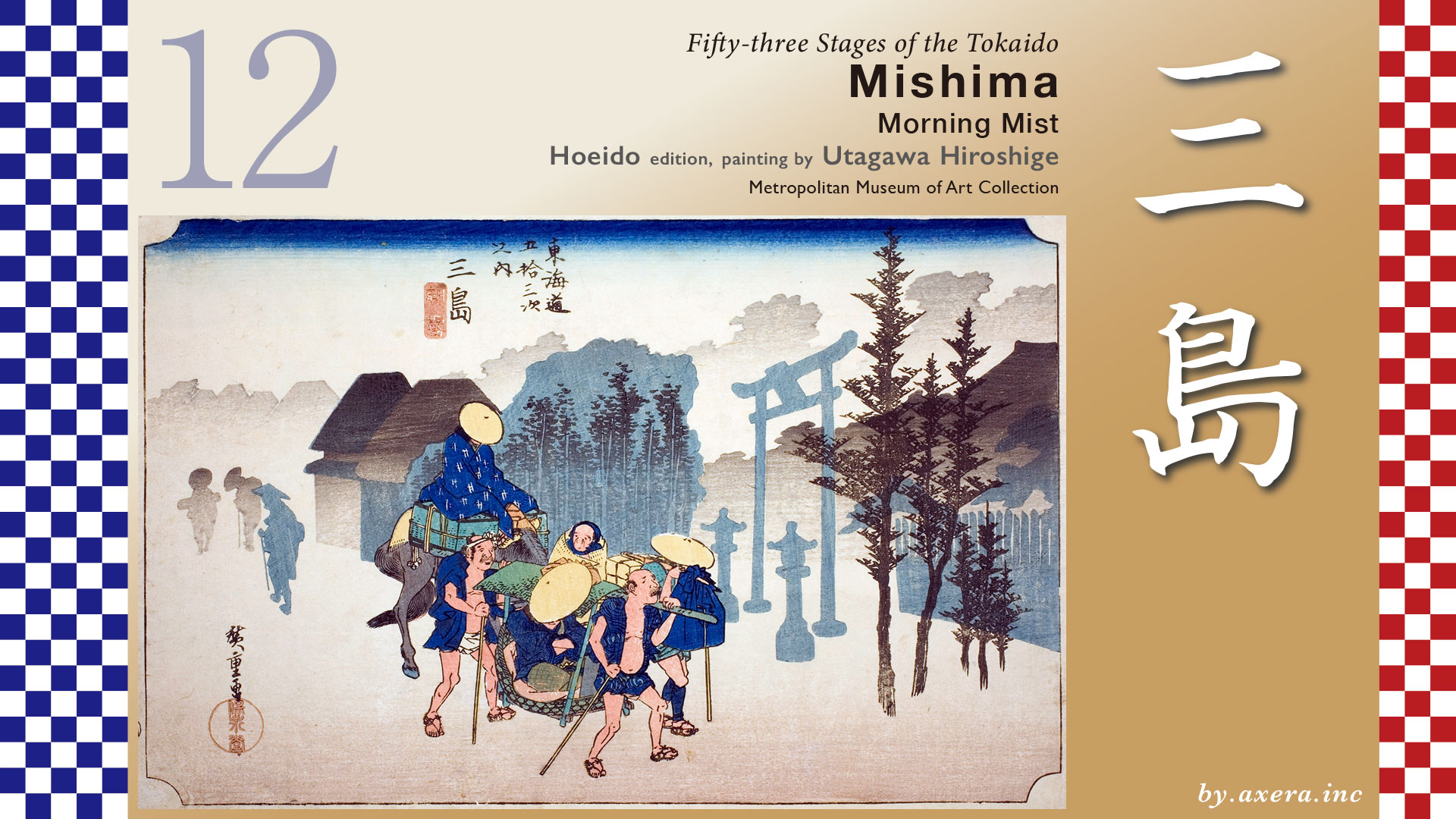
Mishima prospered as the gate town of Mishima-taisha Shrine. This painting depicts a morning scene of a traveler about to leave in front of the symbolic torii gate.
At that time, the total distance between Odawara-juku and Hakone-juku, 4 ri, and between Hakone-juku and Mishima-juku, 4 ri, was called Hakone-hachi-ri, and was considered the greatest geographical difficulty on The Tokaido.
The distance from Hakone-juku to Mishima-juku was about 15 km to be exact, and after leaving Hakone-juku, one had to first climb up many slopes to the Hakone Pass.
First, from the side of the Ashikawa’s stone Buddha group, climb “Mukou-zaka,” “Akaishi-zaka,” “Kamaishi-zaka,” and “Kazakoshi-zaka,” in that order.
From the next “Hazamaishi-zaka”, the old highway, which is no longer in use due to road repairs, heads toward Hakone Pass on Route 1. After crossing the Hakone Pass, you will enter Izu Province, this time going downhill.
After a short distance, you will pass by a teahouse where travelers on The Tokaido were entertained. This teahouse was started by Kaseya Yohei, an Edo merchant who saw the hardships of crossing the Hakone Mountains, and contributed funds to the establishment.
The Tokaido, called the Hakone Old way in this area, runs down the road, not far from Route 1, and eventually reaches the side of Yamanaka Castle Ruins. From here, if the weather is fine, one can enjoy a beautiful view of Mt. Fuji.
Around Ichirizuka in Sasahara, stone pavement still remains, reminding us of the old The Tokaido. You can also see the Izu Peninsula and the city of Numazu on your left.
The Tokaido continues to descend variously named slopes, such as Nagasaka, Shigure-zaka, and Usukoroge-zaka, until it merges with Route 1 at the Izu Jukan-do area. At the Nishikida Ichirizuka area, you can see Mt.Fuji.
The Tokaido again parted from Route 1 and continues parallel to the road, which is lined with pine trees and cobblestone pavement. Ahead, you will descend Atago Slope, cross the JR Tokaido Line, and climb Imai Slope. In the end, you can see that it is all downhill all the way to Mishima.
10
A little further on, crossing the Oba River at Shinmachi Bridge, you will enter Mishima-juku. This Oba River was the sacred area of the Mishima Taisha Shrine, and was therefore called “Kangawa” by the local residents. From here to the Sengan-doi of the Sakai River, about 1,400 m away, is the extent of Mishima-juku, which was the domain of the Edo shogunate. With two Honjins and 74 inns, Mishima-juku was very busy as a post station before Hakone.
When you see a large torii gate on your right, you are at Mishima-taisha Shrine, which was called Mishima Shrine in the Edo period. As the principal shrine in Izu, Mishima-taisha Shrine was trusted immensely by many samurai families, including Minamoto no Yoritomo.
Hiroshige depicted the view in front of this torii gate with the subtitle “Morning Mist.
Going left in front of this torii gate was the Shimoda kaido, which led to Shimoda via Yugashima and Amagi Pass.
Let us take a closer look at Hiroshige’s painting.
First, the torii on the right is the first torii of Mishima-taisha Shrine. Immediately in front of it is the Tokaido, and Hiroshige is standing on The Tokaido, looking westward. In the center of the painting are a guest on a palanquin, a palanquin porter, a retainer with luggage, and a guest on a light horse and the stable boy who controls it. They are heading toward Hakone on The Tokaido in the early morning.
Both the palanquin and the horse are nodding sleepily, which is very morning-like. Except for this group of travelers, everything else is painted in a thin, shadowy, undulating style, depicting the scene in the morning mist. The artist also made full use of blurring to create the atmosphere of a foggy morning.
This painting was actually a second print, and we chose it for this exhibition because it was in good condition.
This is the first print, but we have corrected a lot of folds, stains, and other areas of poor condition. The entire painting has a more distinct, monochrome shadowgraphic expression. The coloring has been changed to black with a blur called “Ichimonji” at the top, and the overall impression is colorless, which I think gives a good impression of the morning atmosphere.
When I look at the second print again, this time it looks brighter and flashier. It is strange.
The Reisho edition is drawn mainly in the area of the inn in front of the torii gate. The Tokaido in front of the torii gate is drawn much wider. Also, it seems that the large tree next to the torii gate was not actually there, and the Shimoda kaido to the left of the torii gate is also omitted.
The Gosho edition seems to be a picture looking at the Hakone side of the Sakai River from around Sengan-doi via Mishima-juku. In reality, there are no such ups and downs.
Poem editin may be a painting of the bridge over what is now the Genbei River on a snowy day, as seen from downstream. The area to the left of the bridge, where the people are depicted, is the current location of the Eel Sakura-ya.
See also Hokusai’s “Thirty-six views of Mt. Fuji. This is a depiction of the famous large “Yatate-no-Sugi” cedar tree that stood beside Yamanaka Castle, which was located between Mishima and Hakone. It is called “Yatate-no-Sugi” because in ancient times, when warlords went into battle, they would shoot arrows to predict their victory or defeat. Legend has it that during the Warring States period, many arrows pierced the cedar tree during a major battle, causing red blood to flow from the tree.
I have actually been here. The road width is different from back then, but the torii gate is in front and the lanterns are down on the precinct side. The view of the inn forested in the distance is not there now, and you can see tall buildings in the distance, which is more modern. Now that National Route 1 runs through the south side of the street as a bypass, the traffic volume seems to have decreased considerably. However, this destination, including this location, is still the center of Mishima.
20
I tried to make this picture look like a morning mist, and fit the overall size of the picture to that of Hiroshige’s painting, and inset the travelers. In this way, the view of this place does not seem to have changed much since then, anyway, for modern things.
The founding of Mishima-taisha is unknown, but the name of the place, Mishima, is said to have come from this shrine, which is very old. It was also the site of the Izu provincial government in the Nara period, and since the raising of the flag of Minamoto no Yoritomo, the shrine has been worshipped by samurai and has developed as one of the shrines in Izu and has become the center of the town of Monzenmachi. At that time, the weeping cherry trees on the shrine grounds were very beautiful and crowded with people.
Looking at the torii gate painted by Hiroshige from behind, one can see that the Shimoda kaido extends straight ahead, indicating that the area was also the center of Izu and a major transportation hub.
Looking at the Taisho era photo, the lanterns are visible both in front of and behind the torii gate. Is this due to road expansion?
During the Edo period, the inn was said to be prosperous, with many guests staying there before crossing Hakone and those staying after crossing Hakone. Mishima was also home to so many Meshimori-onna that the term “Mishima joroshu,” made famous by the noe bushi, was born, and the entire inn was also a tourist attraction.Meshimori-onna” refers to private prostitutes. Today, Mishima is more famous for its delicious “Eel town Mishima”, including Sakuraya, than as an inn town.
This is a Google Street View view from above the place where Hiroshige painted. The orange line is The Tokaido. It is hard to see in the photo, but the road to Numazu is almost a gentle downhill, and the area is so blessed with water that you can always find mineral water when you turn on the tap at a small children’s park along the way. In front of the mountain on the left, you can also see Kakitagawa Park, famous for its spring water from Mt.Fuji. Some researchers believe that sakura shrimp, a specialty of Suruga Bay, grows only in this area because of the spring water from Mt.Fuji. In this way, it is no wonder that the Edo Shogunate designated Mishima as its territory.
Lastly, please try the eel bowl at Sakuraya, an eel restaurant in Mishima founded two years before Hiroshige’s death. The eel is cleaned in Fuji’s subterranean water. The fish hook in the center of the bowl is evidence that the eel was natural, which is wonderful.
コメント