
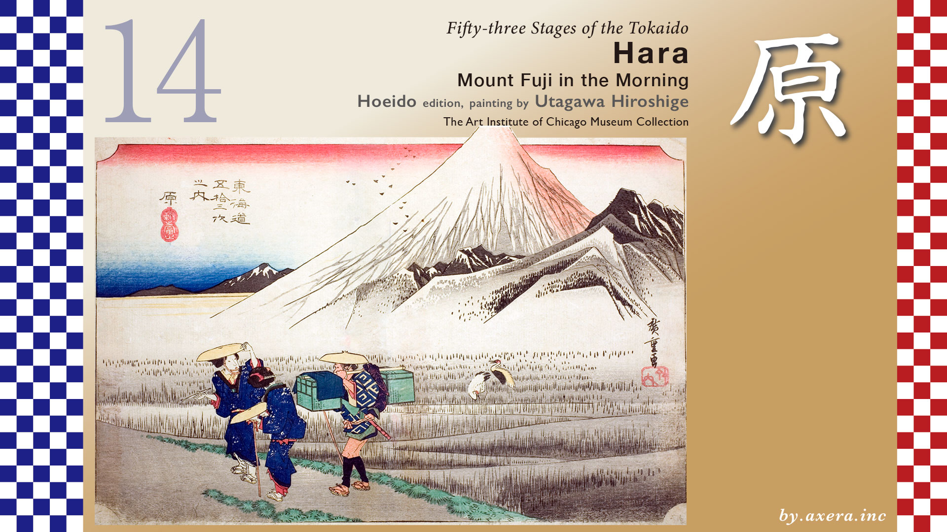
This painting depicts a traveler looking back at Mt. Fuji just after sunrise, just past Hara-juku.
Hara-juku is about 6 km from Numazu-juku, and is a very small relay station with one Honjin and one Waki-honjin.
The Tokaido road splits off from the old No. 1 Senbon Kaido road at Kongoji Temple, and beyond that point, around Nishimakado, is the western end of Numazu-juku.
Then, before Katahama Station, cross Matsunaga Ichirizuka and continue straight ahead in a northwesterly direction.
JR Tokaido Line crosses the tracks, and you will soon reach Higashi-mitsuke, the eastern end of Hara-juku.
There are two things in Suruga: Mt. Fuji and Hakuin of Hara.” This is a popular song in praise of Hakuin, a Zen monk of the mid-Edo period who is said to be the founder of the Rinzai school of Zen Buddhism. Shoinji Temple, where Hakuin’s tomb is located, is just ahead on the left.
About 1.4 km from that Higashi-mitsuke, a short distance from the entrance to JR Hara Station, is Nishi-mitsuke, which shows how small Hara-juku is. To the left of Nishi-mitsuke is also a sake brewery founded in the Edo period that produces a local sake named Hakuin Masamune.
Further ahead is Hara-juku’s Ichirizuka, and further ahead, around the Tennosha Shrine and Sengen Shrine, is the area where Hiroshige painted “Mount Fuji in the Morning”.
At that time, this area was called Ipponmatsu-shinden, and there was a vast swamp called Ukishima-numa on the north side. The area surrounding the waterfront was also quite extensive, and it was a marshy area with no boundaries. The map includes the Ukishima-numa, which no longer exists.
Here is a map from the Geospatial Information Authority of Japan showing the current elevation differences.
During the Edo period, the light blue areas on this map were almost entirely marshlands and swamps.
In the very early days, a part of Suruga Bay gradually became a vast marshland as sand and gravel from the Kano River, Fuji River, and Mount Aitaka alluviated and formed a sandbar, which eventually became a lagoon.
I have included The Tokaido and the location of the Honjin on this map. You can see that The Tokaido runs through a greenish, slightly elevated sandbar area. From the name of this marshy area, Ukishimagahara, “hara” as a place name was established. This wetland also served as a bird sanctuary, as it should, and many migratory birds flew in and out of the area!
You can see that the Tomei Expressway, the New Tomei, and the Shinkansen also pass through the foot of the mountains because they do not like this soft ground.
This is covered by the surface of the water where boats could come and go at that time.
Ukishima-numa is the general name for a group of lakes and marshes that existed in the marshland, including Kashiwahara-numa, Sutsu-numa, Fuji-numa, O-numa, and Hiro-numa. Furthermore, the water surface depicted in light blue is the only water surface that remains in the current record, and a wide area of the light blue area surrounding this map was in a marshy state.
Let’s take a closer look at the actual Hiroshige painting.
Perhaps as a counterpoint to the twilight of Numazu, here we have a morning view. Fuji has been given a slight red color on its eastern side, indicating that the morning sun hits it before the surrounding landscape. Fuji is depicted protruding from the frame, and the craggy mountain to its right contrasts with Mount Ashitaka. A mother and child with their luggage carrier look back at the spectacular view and exclaim in admiration.
The painting also depicts two migratory red-crowned cranes that landed in the marsh, but no one seems to have taken them seriously, as the capture of these birds was forbidden in the Edo period.
Ukishima-gahara is depicted as if it were covered with fine reeds as far as the eye can see, as if the reeds stretched far into the distance.
The Reisho edition is a painting of Mount Fuji viewed from the same position, but the size of Mount Fuji is emphasized so much that the peak is not depicted. Fuji from a considerable distance, so you can see that the marshland in front of the foot of the mountain was vast.
Gosho edition is a view of Mt. Fuji from the Kashihara area near the current JR Higashi Tagonoura Station. The Tokaido, the waterfront, and the marshland are color-coded so that you can see the ridiculously wide Ukishima-ga-hara and the ridiculously large Mt.Fuji.
Now, Ukishima-ga-hara Nature Park has been built on the north side of JR Higashi Tagonoura Station, where you can imagine the marshland that used to be there.
The Poem edition is the same as the Gosho edition, with Ukishimagahara in the foreground and Mt.Fuji. You can see that The Tokaido runs through the sandbar in front of the marshy area where reeds grow all the way to the back. It is interesting that Mt. Ashitaka is very rugged.
It is said that this Triumphant Weather by Katsushika Hokusai was also a view of Mt Fuji from this area. Fuji in a very modern style, and although the floating island in the foreground is not depicted, the spaciousness of the mountain is well expressed.
This photo was taken of the same place in 1918. There are houses to the far end already, but up to this time, the landscape was quite peaceful.
I actually went to this location and looked in almost the same direction. First of all, this is a morning photo I took in January 2010. You can’t see all the way to the marshland, but you can see the morning sunlight shining through from the right.
This is a photo taken in April 2025 in approximately the same area. Unfortunately, Mt Fuji’s head was hidden by clouds.
I went a little further to a more unobstructed area and took this photo. There are still no moorland or cranes, but instead of moorland reeds there are factories and instead of travellers there are trucks coming and going.
This is a view from the sea side on GoogleMAP street view. Hiroshige’s viewpoint is included in red gradient. Overall, the area has been landlocked, but you can see that the former Ukishima Swamp and the lowlands around it have been landlocked and turned into rice paddies, fields, and factories.
In addition, the place Hiroshige drew at that time was Ipponmatsu Shinden, but there were 11 other settlements around Ukishimanuma named Shinden in addition to that. This shows how active the development of new rice paddies was in this area. Shinden” means newly developed rice fields.
This is a rare view of Ukishima-gahara from the early Meiji era, which was published in National Geographic magazine. If this area had been left as a bird sanctuary instead of being reclaimed, it could have become a major tourist attraction as a wetland with the best view of Mt Fuji and Mt.Ashitaka. It is a pity.
I swung the viewpoint to the west. I put The Tokaido there in orange. You can see The Tokaido and Senbon Matsubara continue along the sandbar. Now, the Numakawa River has been created for drainage of this area and serves to keep it landlocked.
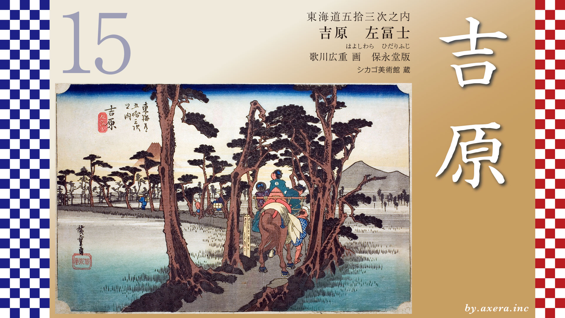
The Tokaido continues onward, crossing the outlet of the Numakawa River to Yoshiwara-juku.
コメント