

Fifty-three Stages of the Tokaido
Okitsu
Okitsu River
Hoeido edition, painting by Utagawa Hiroshige
The Art Institute of Chicago Museum Collection
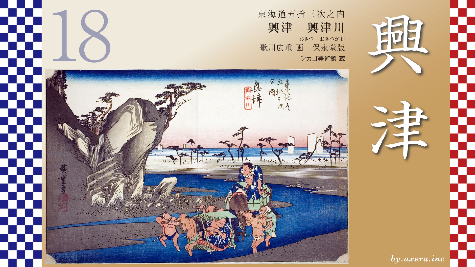
This depicts the crossing of the Okitsu River, located just downhill from the Satta Pass.
The distance between the honjin from Yui-juku to Okitsu-juku is about 9.2 kilometers, but once you cross the Satta Pass, Okitsu-juku is just around the corner.
The Tokaido descends from the Satta Pass, makes a large detour toward the mountains, and then heads toward the sea.
It crossed the Okitsu River near the current JR railway line. A temporary bridge was built over the Okitsu River in winter, but in warmer seasons, people crossed the river on foot.
The Tokaido merges with Route 1 after crossing the Okitsu River, and branches off to the right at the Okitsu Nakamachi Nishi traffic light to become the Minobu Michi Road. The Minobu Michi Road followed the Okitsu River upstream, then ran along the Fujigawa River, passing through the foot of Mt. Minobu and Kuonji Temple, and continued on toward Kofu.
Beyond that, after passing through Okitsu Ichirizuka and JR Okitsu Station, there are Higashi Honjin and Nishi Honjin, which form the center of Okitsu-juku.
However, when it comes to Okitsu, Seikenji Temple, located a little further ahead, was famous.
Please take a look at this picture from the Edo period. During the Warring States period, when Tokugawa Ieyasu was known as Takechiyo, he was held hostage by the Imagawa clan in Sunpu and received an education from the priest of Seikenji Temple.
In the Edo period, the temple also received donations from Ieyasu’s third daughter, including the Buddha hall and mountain gate. As a result of this relationship, Seiken-ji Temple was permitted to use the three-leafed hollyhock crest and held over 200 koku of land for 260 years during the Edo period, receiving the strong support of the Tokugawa clan.
The three-leafed hollyhock crest is the family crest of the Tokugawa clan. In other words, it means that he had earned the deep trust of the Tokugawa clan.
It is a famous temple with such a history, but when you actually visit it, you will encounter a surprising sight. The JR Tokaido Line runs between the main gate and the main hall.
Please take a look at the aerial view, as it is easier to understand. In the early days of railway construction, the tracks from Shimbashi to Shinagawa were laid across what was then completely sea. Despite having the technology to do so, they deliberately chose to run the tracks through the grounds of Seikenji Temple. This was a form of bullying by the Meiji government, formed by the Satsuma-Choshu alliance, against those associated with the Edo shogunate.
Originally, after the Meiji Restoration, the vast lands surrounding Seiken-ji Temple were also mostly seized by the new government. Nowadays, tunnels for the Tomei Expressway and Shinkansen even run through the mountains behind Seiken-ji Temple.
Let’s take a closer look at the Okitsu River depicted by Hiroshige.
The painting shows two large sumo wrestlers being carried on foot. In fact, sumo wrestlers were permitted to cross the river on foot using the footbridge. However, the wrestlers depicted in the painting apparently disliked doing so and instead relied on porters, being carried in a palanquin known as a “Yotsuten,” which is carried by four people. The porters, who are aware that they are carrying sumo wrestlers, all look very strained. The horse-men of the horse carrying both the sumo wrestlers and the cargo also looks worried as he watches the horse. The fact that the sumo wrestlers are holding swords suggests that they are retainers of a daimyo.
You can see that the rocks on the mountain leading to Satta Pass are quite rugged.
The pine forest in the background is a scenic spot called “Konumi Beach,” which is mentioned in the Manyoshu poetry anthology. It is the beach where a lover wrote, “I will wait for you at this beach, so please come over the difficult Satta Pass.” Beyond that, the sea where only the white sails of boats can be seen is Suruga Bay.
During the Edo period, the average water depth of the Okitsu River was about 40 centimeters under normal conditions, as depicted in this painting. However, when the water level exceeded 90 centimeters, horse-drawn ferry service was suspended, and when it exceeded 130 centimeters, even passenger ferry service was halted.
Furthermore, when researching why sumo wrestlers are depicted here, it appears that there was actually a wrestler named Kiyomigata at that time, and he was already in his fifth generation. The first generation was Kiyomigata Matazo, and he is still recorded as a retired wrestler name by the Japan Sumo Association. However, it is unclear whether the first generation, who was from Mikawa Hazu, had any connection to Okitsu. However, it seems that the first Kiyomigata Oyakata was involved in sumo entertainment in the Mikawa region, and it seems that he traveled through the Tokaido on his way to Mikawa for entertainment purposes in accordance with the sankin-kotai system.
The Oyakata is a leader in the world of sumo wrestling.
There is a second print that is slightly brighter overall than the one I thought was the first print. Perhaps this is the first print. It is difficult to judge, so please take a look at both.
There is a second print that is slightly brighter overall than the one I thought was the first print. Perhaps this is the first print. It is difficult to judge, so please take a look at both.
The Reisho edition shows a view of Seikenji Temple and Mount Fuji from a sailing ship in Suruga Bay. It shows how famous Seikenji Temple was at the time.
The Gosho edition shows a view from the front of Seikenji Temple toward Shimizu Port and Miho no Matsubara. Here too, the subtitle is “Kiyomi no Seki,” which shows how Seikenji Temple was viewed by the general public.
The Poem editin depicts the crossing of the Okitsu River. The mountain in the background is the Satta Pass. You can clearly see that the Okitsu River does not have much flow.
Hokusai’s Okitsu depicts local specialties. Abalone, turban shell, and tilefish, they look quite appetizing.
I actually went here.
I think this area is the Tokaido, where the Okitsu River was crossed.
I took a look from above using Google Maps Street View. The crossing point is located between the railroad tracks and National Route 1. Looking at it this way, it seems that everything except for the railroad tracks and National Route 1 hasn’t changed much since the end of the Edo period.
In the back, Konumi Beach is now lined with houses and other buildings.
Looking at a photo album published in 1919, you can see that there are quite a few houses along the coast. You can see that the coastline rose significantly due to the Great Ansei Earthquake. You can also see Mount Fuji faintly in the distance.
Currently, the walking path along the upper reaches of the Okitsu River is a famous spot for viewing beautiful cherry blossoms.
This photo was taken from above the Okitsu River, looking west. I covered the Tokaido with orange. From the Meiji to Taisho periods, Okitsu was a popular vacation spot for politicians, who were the privileged class at the time. It is said that this was because the scenic Kiyomi-gata Lagoon was right in front of them.
However, construction began on the Okitsu Pier in 1962, and the historic Kiyomi Lagoon was filled in. I colored the filled-in area blue. It is clear that Okitsu was being transformed into a huge port city. Kiyomi Temple, which used to be right in front of the sea, is now quite far from it. This is a current photo taken from the location of the red gradient, which was the shoreline at the time.
In addition, in 1889, the temple grounds of Seiken-ji Temple were divided by railroad tracks, and the temple officially donated the land for the development of Okitsu. Regardless of whether this is true or not, I would like to applaud the mature response of Seikan-ji Temple.
The name of the local specialty, Kiyomi orange, is said to have originated from Seiken-ji Temple and Kiyomi-gata Lagoon.
Now, ahead on the left, you can see Kunozan, where the tomb of Tokugawa Ieyasu is located. The next relay station, Ejiri, is in Shimizu, so it’s just around the corner.
コメント