
Fifty-three Stages of the Tokaido
Ejiri
Distant View of Miho
Hoeido edition, painting by Utagawa Hiroshige
The British Museum Collection
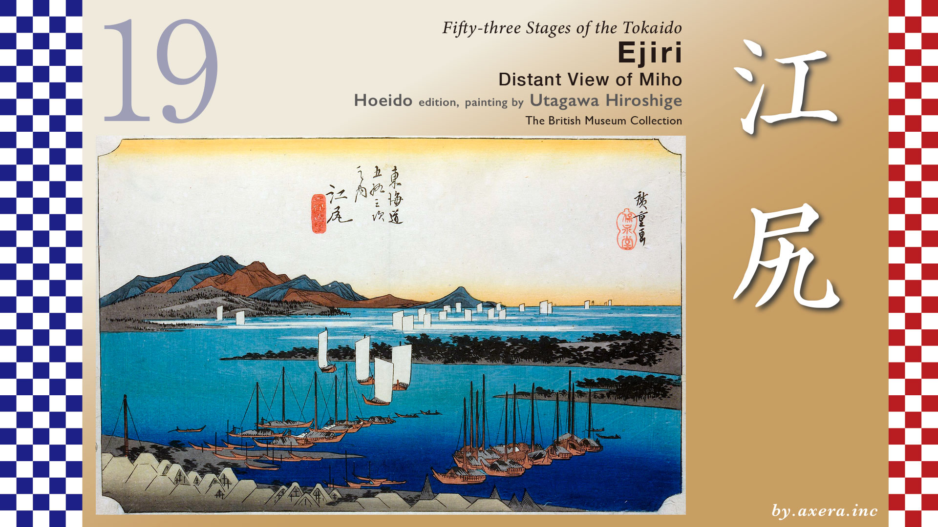
Ejiri is a town that was built on a sandbar in the Tomogawa River, and this painting depicts a distant view of Ejiri-juku, which is now Shimizu and Shimizu Port.
The distance from Okitsu-juku to Ejiri-juku is about 4.3 km. In the Edo period, it would have taken about an hour to walk this distance.
When you leave Okitsu-juku, you will see Seikenji Temple on your right. It is a famous spot in this area, but it is a little sad that the temple grounds are now divided by the JR railway line. Even when you look up from the Tokaido, you can only see the roof of the temple.
The Tokaido crosses the Ihara River as it heads south under Route 1 Bypass.
A little further on is Hosoi no Matsubara, where the Tokaido turns right off the bypass and enters a small road. At that time, there was a beautiful row of pine trees stretching for about 360 meters.
There is also a monument called “Muen-san no Hi” (Monument to the Unknown) at this fork in the road.
When these trees were cut down for oil extraction in 1944, a large number of human bones were excavated from this site. These bones are believed to be those of travelers who died on the Tokaido Road, and the townspeople carefully collected them and enshrined them in a temple. A memorial monument was erected at the fork in the road in Matsubara to comfort the spirits of the travelers who died here at that time.
When you see monument to the unknown to the unclaimed dead, you realize that although the Tokaido is just a road, traveling was always dangerous. You also get a sense of how people at that time viewed life and death.
Cross the traffic light at Ejiri Higashi, which is the road to the current Shimizu Station, and the Tokaido turns sharply to the right toward the Honjin of Ejiri-juku.
At the next turn, the road bends to the left and crosses the Tomoe River at Chigo Bridge. On the other side of the bridge was a place where public notices were posted.
A little further on, the road split into two branches, with Shimizu Minato on the left and the Tokaido on the right. Continuing west on the Tokaido, you will reach an intersection with a road sign. At this intersection, you could return to Shimizu Minato by going left. Nowadays, there is a famous store selling Oiwake yokan.
Actually, most people today wonder where this place called “Ejiri” is located. It was first absorbed into Shimizu City, and then became Shimizu Ward in Shizuoka City, leaving only the name Ejiri-cho. The name Shimizu comes from Shimizu Port, which flourished at the mouth of the Tomoe River, just like Ejiri-juku. I have highlighted Ejiri-juku and Shimizu Port in orange on the map.
This is a bird’s-eye view of Ejiri-juku at that time.
Ejiri was originally ruled by the Imagawa clan during the Muromachi period, who used it as an outer port of Sunpu, a naval base, and a commercial port. In 1571, the Takeda clan of Kai, which had no access to the sea, invaded and ruled this area, building Ejiri Castle. After the fall of the Takeda clan in 1582, the area came under the control of the Tokugawa clan. Even after Tokugawa Ieyasu established the Edo shogunate, Ejiro continued to serve as a military port to keep an eye on the western regions, as part of the dual political system between Edo and Sunpu.
In 1601, 53 stations were designated as new post stations along the Tokaido, but the shogunate somewhat forcefully added Ejiri-juku, located just before Sunpu. At the same time, Ejiri Castle, built by Takeda Shingen, which was located at the end of the unnaturally crooked Tokaido, was abandoned.
In 1615, the shogunate granted 42 households in Shimizu Port the right to operate as shipping brokers, shifting the port’s center to the mouth of the Tomoe River. As a transit hub for goods transportation between Edo, Osaka, Kofu, and other regions along the Tokaido, Shimizu Port thrived with numerous shipping vessels and experienced significant development.
Speaking of Shimizu, Jirocho (real name: Yamamoto Chogoro) is famous, but he was born in February 1820 in the center of Shimizu Port. The year after Hiroshige completed his Fifty-three Stations series, his foster father passed away, and at the age of 15, he took over the family’s rice transport business. While continuing to work in the family business, he repeatedly engaged in gambling and fights, and at one point, he killed someone in a fight and became a vagrant. However, by the end of the Edo period, he had returned to Shimizu.
In 1868, the bodies of crew members killed by the new government army were recovered from the Kanrin Maru, which had been left abandoned as a rebel ship in Shimizu Port, and were given a proper burial with a grave erected in their honor. Jirocho is said to have declared, “When we die, we all become Buddhas. There are no government troops or rebel troops among the Buddhas.” Through this connection, he became acquainted with Yamaoka Tesshu, a former Tokugawa shogunate official, and with his assistance, he made significant contributions to the development of Shimizu, including port improvements. Jirocho’s perspective on the value of human life is also quite intriguing.
Let’s take a closer look at Hiroshige’s painting.
The most distinctive feature of this painting is that it is the only one in the series that does not depict Hiroshige’s signature commoners, but is instead a complete landscape painting. The mountains in the background are Mt. Ashitaka on the left and Mt. Futago in Hakone and the Izu Peninsula on the right. Originally, Mt. Fuji should be visible on the left, but it is cut off.
On the left side in the foreground, the roofs of Ejiri juku are depicted, with a considerable number of boats drawn in the background. The black promontory protruding from the right is the northern tip of Miho Pine Grove, known as Miho Masaki. In the foreground is Shimizu Port, and in the background, Suruga Bay is filled with numerous boats, hinting at Ejiri’s natural excellence as a port. In addition to commercial boats, small fishing boats and nets drying on sharp angles are also depicted along the coast of Shimizu Port. At that time, there were boats running from Numazu to Ejiri, and there were also ferries that took a shortcut through the Tokaido by passing through the Fuji River and Satta Pass.
It is said that Hiroshige’s Ejiri was painted with reference to this painting. They do look similar. In other words, the perspective of Hiroshige’s painting is the view from the top of Mount Kunozan, where Ieyasu’s tomb is located.
The Reisho edition depicts the view of Mt. Fuji from Miho no Matsubara. The slightly higher mountain on the left is Mt. Ashitaka, and the opposite shore is Kambara, Okitsu, and Yui.
The Gyosho edition depicts a snowy landscape just before turning south at Oiwake and entering the village of Shimizu Minato.
The Poem edition depicts the view of Mt. Fuji from the western end of Ejiri-juku.
Hokusai depicts two travelers on the north side of what is now Shimizu Station, near the eastern end. This is what travelers looked like in the cold season during the Edo period.
Hokusai also depicted Ejiri in his Thirty-six Views of Mount Fuji. Although it is unclear exactly where this place is, it is said that it may be the banks of the Tomoe River along the road from Shimizu Port, as it is described as being windy.
Now, take a look at Miho no Matsubara on Google Maps. It is considered one of the three most famous pine groves in Japan and has been designated as a national scenic spot.
Currently, a narrow strip of pine forest about 7 km long remains on the east side of this huge sandbar, along the open sea.
When you think of Miho no Matsubara, you imagine a view like this from the east side.
However, the situation seems to have been quite different during the Edo period. Please take a look at the two vertical paintings by Hiroshige.
Documents from the Edo period indicate that the entire Miho Peninsula was covered with pine trees at that time. Miho was a direct possession of the Edo Shogunate and had long been maintained as the jurisdiction of Miho Shrine, known for the legend of Hagoromo.
However, after the Meiji Restoration, this restriction was lifted, and it is said that the pine trees around Miho Shrine, especially on the Shimizu side, were cut down devastatingly. If we recreate the situation at that time in green, it would have looked something like this.
I actually visited the place Hiroshige painted. This is the view from Nihondaira on Kunozan Mountain, which is closest to Hiroshige’s painting. You can see that the pier and huge port facilities, which did not exist at the time, now cover a large part of the sea. The city visible beyond Suruga Bay is Fuji City.
Please take another look at Hiroshige’s painting, Ejiri. Even though there were materials drawn by his predecessors, Hiroshige’s painting technique is truly astonishing.
He excluded Mount Fuji from the painting and instead depicted the view from Mount Kunozan, where Tokugawa Ieyasu’s tomb is located, with the subtitle “Distant View of Miho,” making it part of this painting of Ejiro-juku. In this painting, no one involved in matters of life and death is depicted. By removing the Izu Peninsula and imagining a vast sea, he depicted numerous Benzaisen boats floating peacefully on the sea of Shimizu, which was once a military port.
Hiroshige may have wanted to show the citizens of Edo a peaceful view from Mount Kunozan, where Tokugawa Ieyasu, who brought long peace to this country, is buried, as a sign of respect for him.
Finally, please take a look at this actual photo of the entire Suruga Bay, including Mt. Fuji, Mt. Ashitaka, and the Izu Peninsula.
Let’s look ahead from above Shimizu Station on Google Maps, with the Tokaido marked in orange. As far as the eye can see, there are buildings of various sizes crowded together.
Leaving Ejiri, the Tokaido passes through Kusanagi and soon reaches Fuchu-juku. Beyond that flows the Abe River.
コメント