
Fifty-three Stages of the Tokaido
Kakegawa
View of Akiha Mountain
Hoeido edition, painting by Utagawa Hiroshige
The Art Institute of Chicago Museum Collection
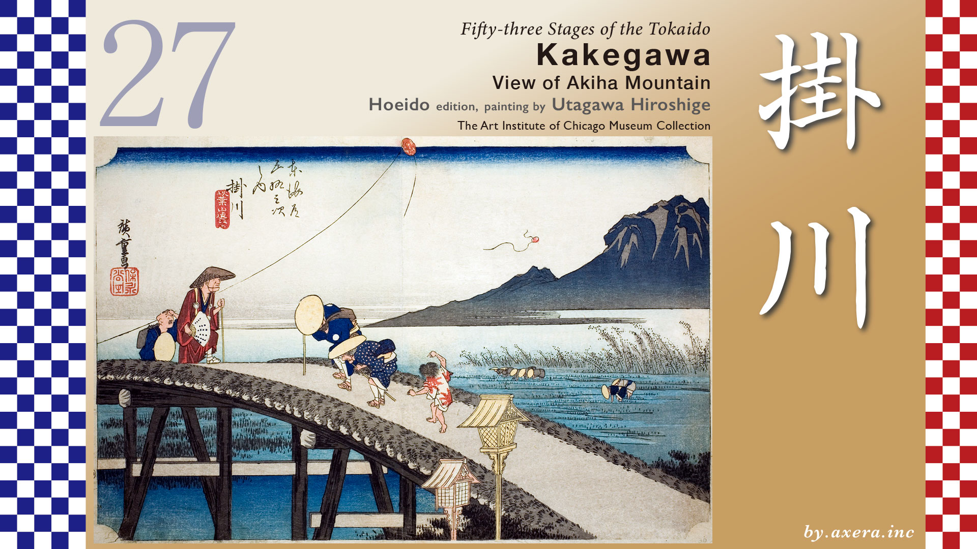
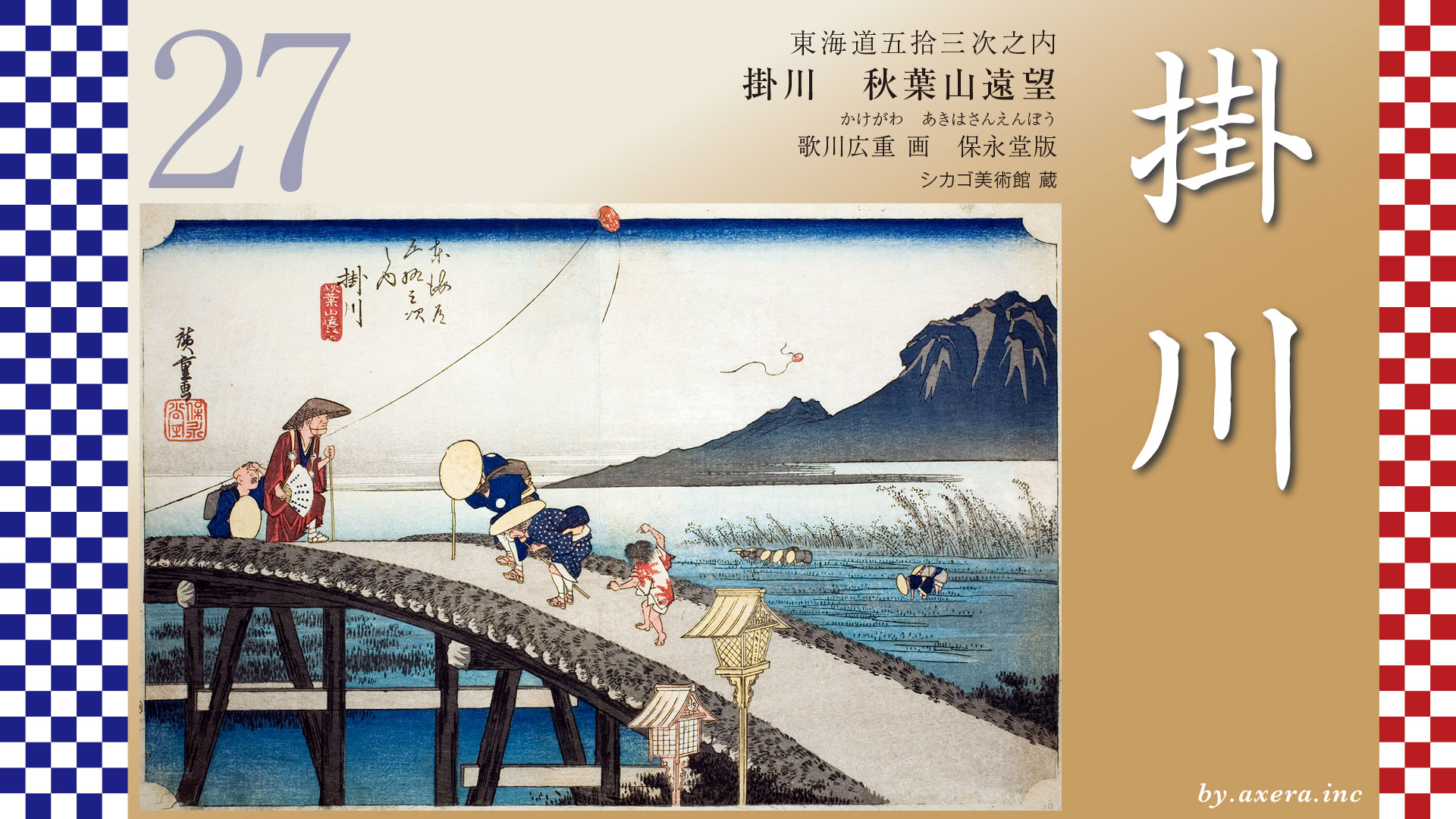
This painting depicts the area around the Futase Bridge, located just before the fork leading to the Akiha-Michi after passing through Kakegawa-juku.
From Nissaka-juku to Kakegawa-juku is about 7.1 km. Continuing another 2 km from there, you could reach Futase Bridge, where the fork with the Akiha-Michi.
Leaving Nissaka-juku, The Tokaido road widens slightly near Kotonomama Hachimangū Shrine, located just to the left. This shrine, whose name “Kotonomama” means “wishes come true as you desire,” was bustling with travelers stopping to pray for safe journeys and the fulfillment of their wishes. Continuing south from here, the road crosses the National Route 1 Kakegawa Bypass and reaches the Date-gata Ichirizuka milestone.
Continuing onward, around Honmura Bridge, turn left and enter the narrow path.
Heading west and crossing the Sakasagawa River, he found himself at the Kuzukawa Ichirizuka milestone.
Continuing onward, turn left around the present-day Shinmachi area, and from here onward, the road winds like a typical castle town’s crank road. Along this route lies the East Checkpoint, which effectively marked the eastern edge of Kakegawa-juku.
After passing the Honjin of Kakegawa-juku, look to your right around Nakamachi and you’ll see Kakegawa Castle.
The Tokaido road veers diagonally onto the right-hand path where the Jukusho-zuka, heading toward the Futase Bridge.
The Jukusho-zuka is said to be a burial mound erected in 940 by Fujiwara no Hidesato to mourn the nineteen members of Taira no Masakado’s clan whom he had defeated. It is still revered today as a guardian deity of the local area.
Crossing Sakagawa River and turning left at the Futasegawa traffic light brings you to Oike Bridge. The Edo-period Futase Bridge spanned the river slightly upstream from the present Oike Bridge. Crossing it led to The Tokaido on the left and the Akiha Michi on the right at the fork.
Here, we overlay a historical map clearly showing the roads of that era onto the Geospatial Information Authority of Japan’s map. Kakegawa-juku was said to be bustling with pilgrims visiting Akiha Shrine at the time. This was because, when traveling the Tokaido from Edo, the first Akiha Michi began at Kakegawa.
The blue route clearly marked on the map was the road leading to Akiha Shrine from various locations, also known as the Akiha Michi. Numerous eternal lamps were erected along the Akiha Michi as tokens of faith and as road markers. So many Akiha Michis existed that it was said almost every road heading north from the Tokaido in Enshu led to Akiha Shrine.
From Kakegawa-juku, the route to Mount Akiha followed the Tenryu-Hamanako Railway, passed through forests, crossed the Keta River, and ascended from Inui Castle.
Akiha Shrine, also known as Akiha Daigongen, gained explosive popularity nationwide as the “God of Fire Prevention” from the time of Tokugawa Tsunayoshi, the fifth shogun of the Edo shogunate, despite being located atop a high mountain. Even today, when traveling the Tokaido Road, you can still see lanterns erected by followers of the Akiha Ko sect everywhere. It shows just how many devotees there were.
Numerous Akiha Ko (Akiha Pilgrimage Groups) were formed in Edo, which suffered frequent fires, and the number of pilgrims reportedly rivaled those visiting Ise. This painting depicts the scene of pilgrims visiting Mount Akiha, created by Hiroshige around 1837.
During the Edo period, pilgrimage trips to places like Akiha Shrine, Ise Shrine, or Mount Oyama were immensely popular. This photograph shows the view from Akiha Shrine toward the Tokaido road in the direction of Kakegawa. It seems the common people of Edo looked forward to seeing scenery like this. Especially around the time Hiroshige’s “Fifty-three Stages of the Tokaido” was published, travel became a major craze, fueled by ukiyo-e prints that evoked the romance of the journey.
Let’s examine Hiroshige’s painting in detail.
In the foreground, two all‐night light of Akiha Shrine are depicted, with people crossing the Futase Bridge beyond them. From the left, a monk accompanied by attendants crosses the bridge, perhaps having finished his prayers at Akiha Shrine. He holds a fan inscribed with writing and a walking stick. An elderly couple passing by bow deeply to the monk in respect, while the child behind them remains utterly indifferent. A Enshu kite soars in the sky, seemingly leaping out of the picture. Another kite, its string broken, drifts toward the mountains.
This bridge is an earthen bridge built over a wooden one, and a child crossing it later holds up a hand to watch a kite flying overhead. Beyond the bridge, many people are depicted planting rice, and the rugged mountain painted further to the right rear is Mount Akiha. The entire scene presents a peaceful spring landscape.
Hiroshige depicts the scene ahead in the Reisho edition. Beyond the bridge stood two pine trees, a stone lantern, and a magnificent torii gate. The two samurai-style figures pointing as they walk are on the Akiha Michi.
In the Gyosho edition, this torii gate is depicted from the front. The road running alongside is the Tokaido, and the path leading up from beyond the front torii is the Akiha Michi. You can really see how deeply the common people revered Mount Akiha.
In the Poem editin version, all of these elements are depicted from the viewpoint just before the Futase River Bridge. This painting gives you a sense of the relative positions, doesn’t it?
The book published in 1918 contains photographs taken almost entirely from Hiroshige’s viewpoint. Beyond the wooden bridge, the first torii gate is also visible. At that time, the torii gate seemed to face almost directly toward the bridge.
I actually visited this place. This bridge is Ooike Bridge, and this is its current state as seen from Hiroshige’s viewpoint. The Edo-period Futase Bridge spanned the river to the right of this one, and today the torii gate and lanterns are no longer visible.
If we imagine the current Ooike Bridge as the Futase Bridge and align it with the composition of Hiroshige’s painting, would this be the view we see?
This is the present-day Akiha Michi as seen from the Edo-period Oiwake intersection. It shares the same composition as the Gyosho edition. With the current road layout, you cross Ooike Bridge and turn right.
Alongside Akiha Michi, such a place of Remote Worship Site to this day.
This is the Tokaido route. On the current road layout, you cross Ooike Bridge and turn left.
Let’s take a look on Google Street View. The road that was a three-way intersection back then is now a five-way intersection. Even today, at the entrance to Akiha Michi, the sign for “Akiha-jinja Shrine Kakegawa’s First Torii Gate Viewing Site” remains. Mount Akiha can be seen small in the distance, showing how much Hiroshige emphasized it in his painting.
Finally, I’ll sketch the Tokaido into Hiroshige’s aerial view looking toward the next Fukuroi-juku. Today, this area’s address is “Ooike,” but to the north lies the Akiha-dori Public Hall, and on the Tokaido side is the Torii-machi Public Hall. Though now only a remote worship site remains, it shows how this area has long been closely tied to Akiha Shrine and its worship.
The Tokaido crosses Ooike Bridge and turns left, then makes a sharp right turn at Nishi-kakegawa Station. Beyond that, to the west, Fukuroi-juku comes into view.
コメント