
Fifty-three Stages of the Tokaido
Fukuroi
Scene at an outdoor tea-stall
Hoeido edition, painting by Utagawa Hiroshige
The Art Institute of Chicago Museum Collection
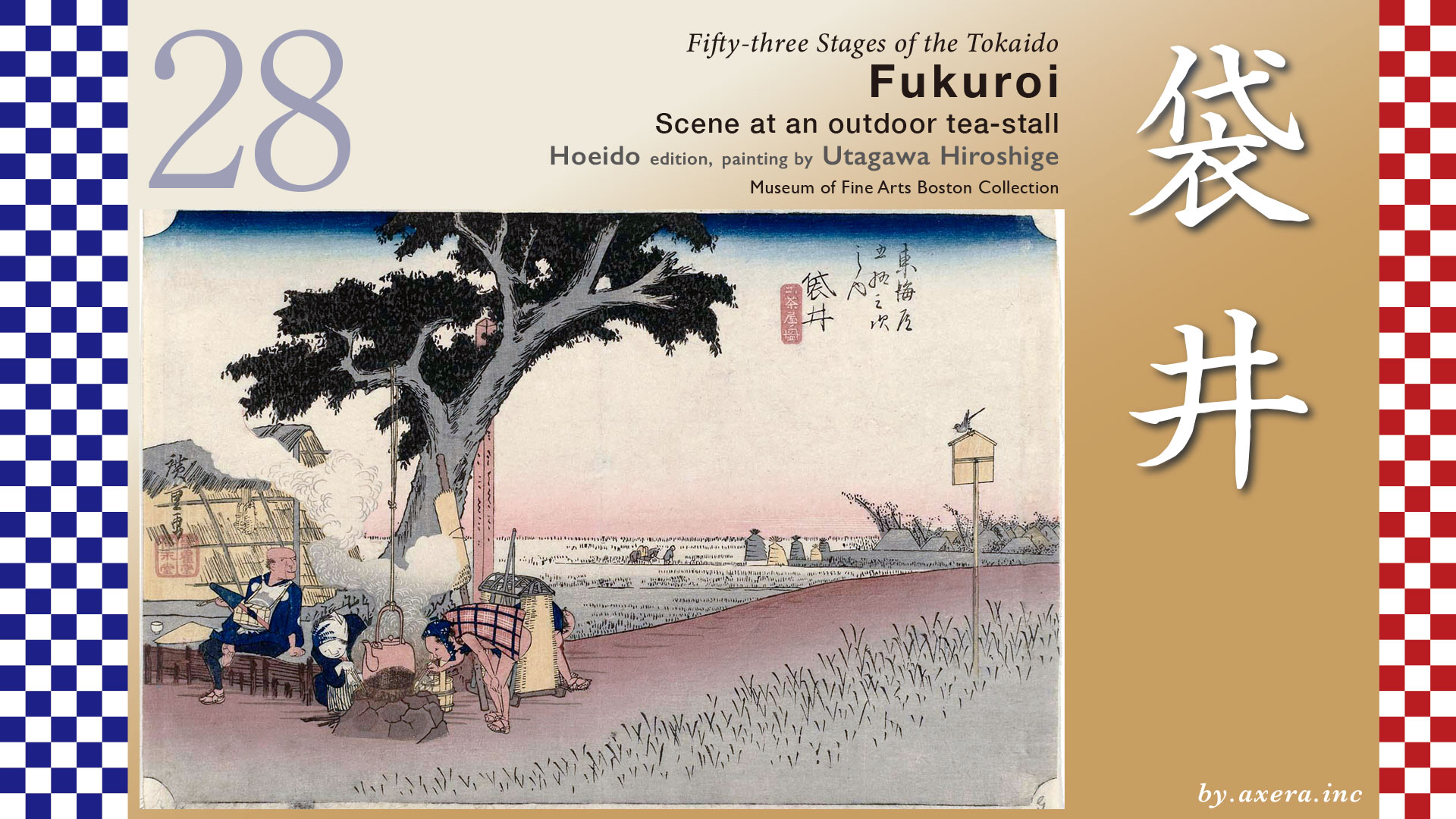
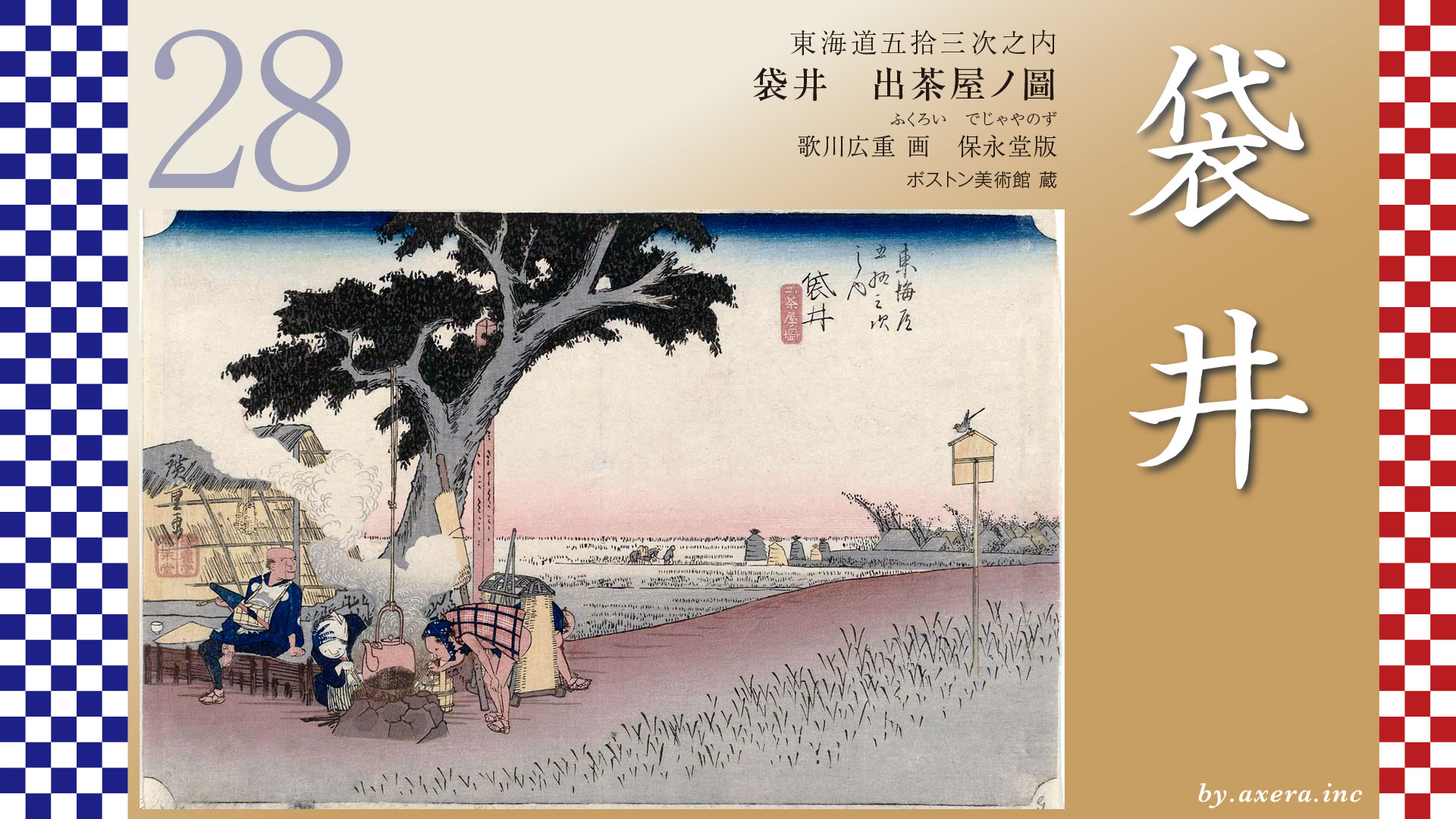
This depicts the scene of a tea shop just before entering Fukuroi-juku.
The distance from Kakegawa-juku to Fukuroi-juku is approximately 9.6 km, but the journey from the Futasegawa Bridge depicted by Hiroshige in Kakegawa to the Amahashi Bridge depicted in this Fukuroi is about 7.7 km.
The Tokaido heads south from the Futasegawa Bridge, passes through the Tenryu-Hamana-ko Railway’s Nishikakegawa Station, and after heading slightly westward, reaches Oike Ichirizuka.
Continuing further west, after crossing National Route 1’s Fukuroi Bypass and the Tomei Expressway, a well-maintained avenue of pine trees appeared around Harakawa. This avenue of pines is said to have continued intermittently all the way to Arai, just before Fukuroi-juku on the Tokaido.
Further west, around the point where the trail crossed the Haranoya River, stood the Naguri Tateba, a resting place for travelers.
Passing through the avenue of pine trees that still remains ahead, just beyond the red torii gate of Fuji Sengen Shrine, stands the Kutsube Ichirizuka. This was the 60th Ichirizuka counted from Nihonbashi.
Zoom in on the map.
Around Arai, where the pine tree avenue ends, you can see the eternal lamp of Akiha Shrine. Eternal lamps built by the Akiha-Ko can be seen in various places here as well, suggesting this area was also bustling with visitors to Akiha Shrine.
Amahashi bridge served as the eastern gate of Fukuroi-juku, marking the official start of Fukuroi-juku. Beyond the Amahashi bridge the Kosatsu board area.
Just before the honjin, there was also a Toiyaba, making this area the center of Fukuroi-juku.
Further along, just before the Ugari River, lies Nishimitsuke, the western edge of Fukuroi-juku. On its southern side, the oldest night lamp in Fukuroi, built in 1799, still stands today.
Hiroshige depicted a teahouse located just before entering Fukuroi-juku from Edo, near the spot past the Amahashi Bridge. The subtitle “Scene at an outdoor tea-stall” refers to a simple structure made of materials like reed mats, serving as a resting place for travelers along the roadside. Hiroshige captures its leisurely atmosphere with a relaxed touch.
The large tree, the signpost marking the Fukuroi-juku boundary, and the Kosatu board on the far right indicate this is the outskirts of the Juku. Under the thatched reed roof on the left, a messenger rests with his pipe. His gaze seems fixed on a long-tailed bird perched on Kosatsu board. Hanging above the messenger’s head are spare waraji sandals, an essential travel item. It was said that back then, waraji sandals wore out after just three days of use.
Beneath a kettle suspended from a large tree, a hearth has been cut out, and smoke billows thickly upward. The shopkeeper, wearing a sister’s kimono, stokes the flames fiercely. A palanquin bearer tries to light his pipe from the growing flames, while his partner, exhausted afterward, sits down to rest.
Beyond the rice fields, a figure can be seen in the distance, leading a horse along the ridge path and carrying goods toward the Fukuroi-juku. To the right lie the rows of houses at Fukuroi-juku. The elevated area beyond the Kosatsu board where birds perch is said to be the earthen bridge known as the Amahashi bridge.
This print is a first edition, so it conveys a leisurely rural scene approaching autumn dusk, creating a landscape that feels serene.
When second printed, the red blur becomes an indigo blur, slightly diminishing the relaxed atmosphere and creating a sharper impression. Comparing them, you can see the difference.
The clerical script version depicts the scene with a wider angle, including the Amanohashi Bridge within the painting. In the sky, kites—a famous specialty of the Enshu region—are depicted rhythmically. The circular kite from Fukuroi, depicted at the center, features a uniquely round shape that is rare even nationwide, making it immediately clear that this painting depicts Fukuroi.
The Gyosho edition features a rare composition depicting the road from the front, with a row of pine trees including a signpost stake, suggesting it may be the West Gate of Fukuroi-juku.
The scene depicted in the poem edition likely shows the area around Arai, featuring private homes and pine groves.
A book published in 1918 contains a photograph taken from nearly the same spot as this one. A wooden bridge clearly spans the water, flanked on both sides by earthen embankments where Mitsuke were apparently set up. The child looking at the photographer has such an adorable gaze.
Here, take a look at Google’s aerial view of the Fukuroi area. Originally, Fukuroi was named for the spring that flowed within a bag-shaped piece of land surrounded by mountains on all sides. That alone shows how low-lying this area was.
Meanwhile, when the shogunate was developing new juku, they considered adding a station between Kakegawa-juku and Mitsuke-juku, as the distance between them was over 15 km. However, the Haranoyagawa River near the midpoint frequently flooded, making passage extremely difficult. Consequently, Fukuroi-juku was established slightly later than other juku, in 1616. The rivers and water conditions of the time significantly influenced the formation of these juku, you see.
Even before becoming a juku on the Tokaido, Fukuroi was already a bustling town serving as the gateway to the famous ancient temples known as the Enshu Sanzan.
The Enshu Sanzan refers to three ancient temples located in Fukuroi City, Shizuoka Prefecture: Hatta-san Son’ei-ji Temple, Bansho-zan Kasuisai Temple, and Iou-zan Yusan-ji Temple. These temples have over 1,000 years of history and have long been revered as sacred sites with miraculous powers.
Son’ei-ji Temple is known as a temple dedicated to the Kannon of misfortune removal, and its misfortune-removing dumplings became a specialty. At its peak, it was a massive temple with as many as 60 sub-temples. Kasuisai Temple controlled Soto Zen temples in Mikawa, Totomi, Suruga, and Izu provinces. After the enshrinement of the Sanjakubo Daigongen from Mount Akiha, it gained renown as a temple for fire prevention.
I actually visited this spot. It’s just a little before the current Amahashi Bridge. Of course, there’s no trace of the leisurely rural landscape Hiroshige depicted; the houses that were visible in the distance now line the road all the way to the bridge. The Tokaido Road is on the right side of the house with the blue wall right in the center. Right next to it, Hiroshige’s painting is displayed, and behind that is the rest area for Fukuroi-juku.
This is the view from crossing the bridge. The road straight ahead in the center is the Tokaido, gently curving to the right as it stretches out.
Please also view Google Street View to see what lies ahead. The Tokaido route, marked in orange, has been improved to pass through city hall grounds and cross a bridge. While getting slightly closer to the Haranyano River, it curves right and heads toward Hamamatsu in the distance. Further ahead, the Tokaido crosses the Ota River, passes over the green Iwata-mikano Plateau stretching to the left and right, and heads toward Mitsuke-juku.
コメント