
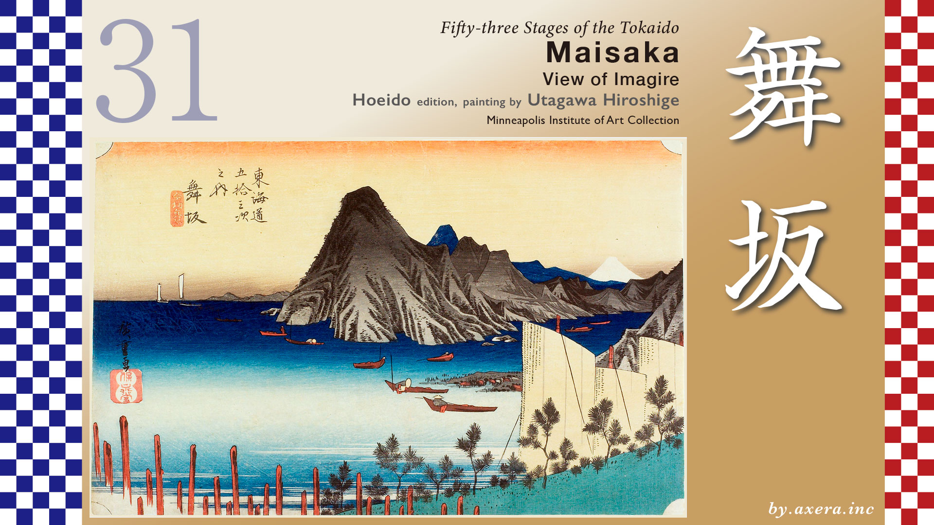
This is a view from the sea of the Imagire Ferry crossing Lake Hamanako, looking toward the Maisaka side.
The route from Hamamatsu-juku to Maisaka-juku is a walk of about 11 kilometers over mostly flat terrain.
The Tokaido road leaves Hamamatsu-juku and runs roughly parallel to the JR railway line as it heads west. Near Takatsuka Station, there were official bulletin board and lanterns at that time.
As you approach Maisaka Station, you can see the dragon lantern of Akiha Shrine on your right. This is a night-time beacon established for pilgrims traveling to Mount Akiha.
From around Maisaka Station, rows of pine trees come into view on both sides. Maisaka-juku began around here, and you can still see many pine trees today.
Please view the wide-area map showing Maisaka-juku, Arai-juku, and Lake Hamanako from here.
After passing through Hamamatsu, the Tokaido route required ferry crossings from Maisaka-juku to Arai-juku. However, by the time Hiroshige depicted this area, it had been struck by several natural disasters.
According to maps from before 1490, Maisaka and Arai were almost connected by land, requiring only crossing a small river flowing out of Lake Hamanako. The entire yellow-green area on this map was also land.
However, the 1498 Meio Earthquake struck the Enshu-nada coast, causing massive land subsidence and triggering a tsunami. The earthquake caused the opening of Lake Hamanako to subside. The resulting tsunami breached the sandbar separating Lake Hamanako from the sea. Consequently, Lake Hamanako, which should have been quite distant from the ocean, became a brackish lake mixed with seawater.
This map depicts the landscape at that time, showing the large, light blue Hamanako Lake.
From here, the Imagire ferry service began operating between Maisaka and Arai. However, disasters continued: in 1510, the sea at Maisaka suffered a major collapse, and in 1699, the Arai barrier across from Maisaka-juku was severely damaged by storm surge.
In 1707, the Hoei Earthquake and Tsunami caused significant damage to Maisaka juku. Across the strait, Arai juku also suffered flooding and collapse affecting 855 houses, and the ferry service sustained major damage. This tsunami damage, combined with improvements to the opening of Lake Hamanako and the relocation of Arai barrire, led to the extension of the Imagire Ferry route connecting Maisaka-juku and Arai-juku. The route was extended to approximately 3.9 km.
Moreover, the Arai barrier was notoriously strict, so much so that it was mockingly called “Enter the gun and leave the woman,”. This led to the creation of the Imagire Ferry here, which combined a long, circuitous boat journey with a harshly enforced checkpoint. However, travelers disliked the Tokaido and instead flocked to the Himekaido, which passed north of Lake Hamanako. This is the green line on the map. Furthermore, the pronunciation of “imagire” also implied severing ties, making it deeply unpopular among women. There was even a period when the shogunate itself promoted the Hime Kaido over the disaster-prone Tokaido.
More than a year after the Hoei Earthquake, travelers still avoided the Tokaido Road, and with reconstruction stalled, a sense of crisis grew. In March 1709, petitions were submitted to the shogunate from six relay stations―Maisaka, Hamamatsu, Arai, Shirasuka, Futagawa, and Yoshida―urging that the Tokaido be used for official travel.
It was not until November 1717, eight years later, that the shogunate’s Road Commissioner finally issued an order restricting passage on the Himekaido. However, despite this strong directive from the shogunate, ordinary travelers were slow to return to the Tokaido route.
Here, we’ll overlay Hiroshige’s viewpoint with a red gradient. Using this as a reference, let’s examine Hiroshige’s paintings in detail.
The wooden stakes in the foreground on the left were driven into the ground as wave-breaking stakes since the Hoei Earthquake. The small pine tree on the right was planted for coastal protection; a considerable number of pines were planted along the shoreline. Both served to mitigate the impact of the waves and winds of the Enshu-nada Sea on ferry boats and other vessels.
A large mountain is depicted in the center of the painting, but this does not actually exist.
This is the depiction of “Imagire” from the “Tokaido Meisho Zue” that Hiroshige referenced when creating this series. According to researchers’ interpretations, it is suggested that Hiroshige may have reused and exaggerated the mountain depicted here.
In the shallow waters of the inlet, five small boats are depicted gathering clams, while snow-capped Mount Fuji is painted deep within the right inlet. To the left of the mountain, Lake Hamanako stretches far into the distance. However, since the foreground is the sea, the idea of a shore planted with pine trees gently sloping down from the right is topographically implausible.
Please see the Reisho edition. It depicts the loading and unloading of cargo, as well as travelers waiting to board, at the stepped landing known as the Gangi of Maisaka. The ferry crossing at Imagire, though subject to strong currents at high and low tides, otherwise offered a leisurely boat journey across the inland sea.
The Gyosho edition depicts cargo being loaded and unloaded from a slightly larger ship. It has a very peaceful feel to it. However, the even taller mountain behind the one on the right does not exist either.
The Poem edition depicts two boats with large sails entering the harbor. In the background, very tall mountains are drawn, but these mountains, too, did not actually exist.
This time, please also view the vertical-format version.
Nearly 21 years passed between the publication of the Hoeido edition and this vertical-format edition, yet this painting too depicts towering mountains that do not exist. Hiroshige passed away three years after publishing this work. Perhaps Hiroshige never actually visited places like Maisaka or Imagire, and never saw the real scenery with his own eyes.
I actually went here. However, the spot where the shore is in front, mountains are to the left, and Mount Fuji is visible in the distance to the right does not actually exist. So, this is a photo I took looking toward Mount Fuji over the point where the Tokaido road coming from the east meets the sea.
This spot is a bit closer to the shore, where the Tokaido descends to the sea.
Maisaka juku had three ferry landings featuring stepped structures called “Gangi” leading down to the water. The “North Gangi” was for daimyo, the “Central Gangi” for samurai, and the “South Ganki” for commoners and loading/unloading cargo. In Maisaka, the “gangi” were called “gange.”
The photograph shows the constant night lamp standing at the site of the Central gangi ferry landing, which most travelers would have seen. Opposite it stands the Nishimachi constant night lamp, and a little further on is the site of the honjin.
Following the direction Hiroshige painted, I raised the viewpoint on Google Street View to roughly the same angle. Mount Fuji is visible small on the right, but compositionally, it seems too different from Hiroshige’s painting.
I raised the viewpoint considerably, incorporated the Tokaido road, and even included the position of the Central Gangi night lantern as seen in photographs. Yet it still doesn’t look like a Hiroshige’s print.
The subtitle of the painting was “View of Imagire,” but it wasn’t an actual scene, was it? Travelers who had walked the Tokaido this far might have muttered, “This isn’t right, is it?” if they’d been carrying Hiroshige’s print.
Let’s take a look at the Tokaido ahead via Google Street View. I’ve marked the Tokaido in orange and the Imagire Ferry crossing in pink.
It’s hard to believe this scenery looked completely different just about 520 years ago. Japan really is a country prone to natural disasters.
The Tokaido continues by boat toward Arai juku.
コメント