
Fifty-three Stages of the Tokaido
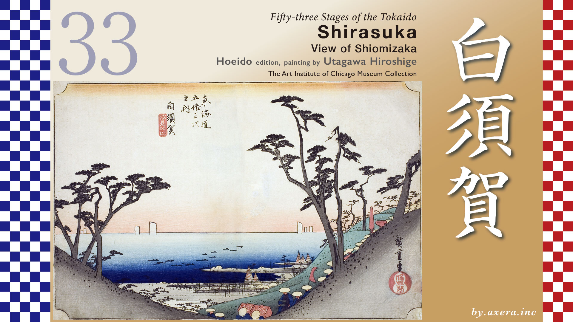
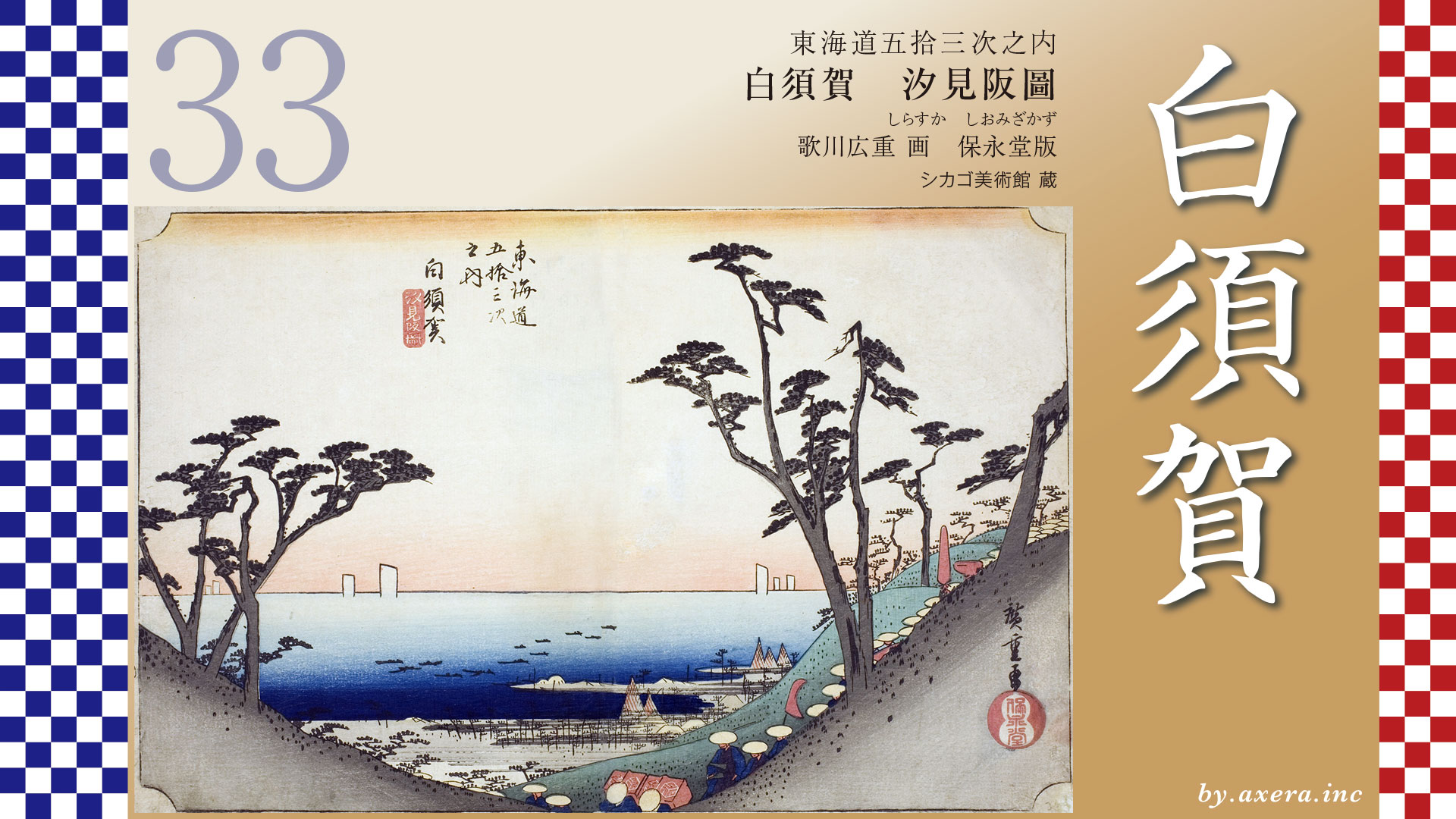
Shirasuka
View of Shiomizaka
Hoeido edition, painting by Utagawa Hiroshige
The Art Institute of Chicago Museum Collection
After leaving Arai-juku, the Tokaido follows the coastline before climbing a steep slope with the Enshu-nada Sea behind it. Hiroshige seems to have depicted the sea viewed looking back from this point. This Shio-mi-zaka slope was known as a scenic spot offering views of Mount Fuji and the expanse of the Enshu-nada Sea.
The distance from Arai-juku to Shirasuka-juku is approximately 6.8 kilometers.
After leaving Arai-juku, the Tokaido heads south, merging with what is now National Route 1. Immediately after Hashimoto, it veers right and continues along a narrow road hugging the mountainside.
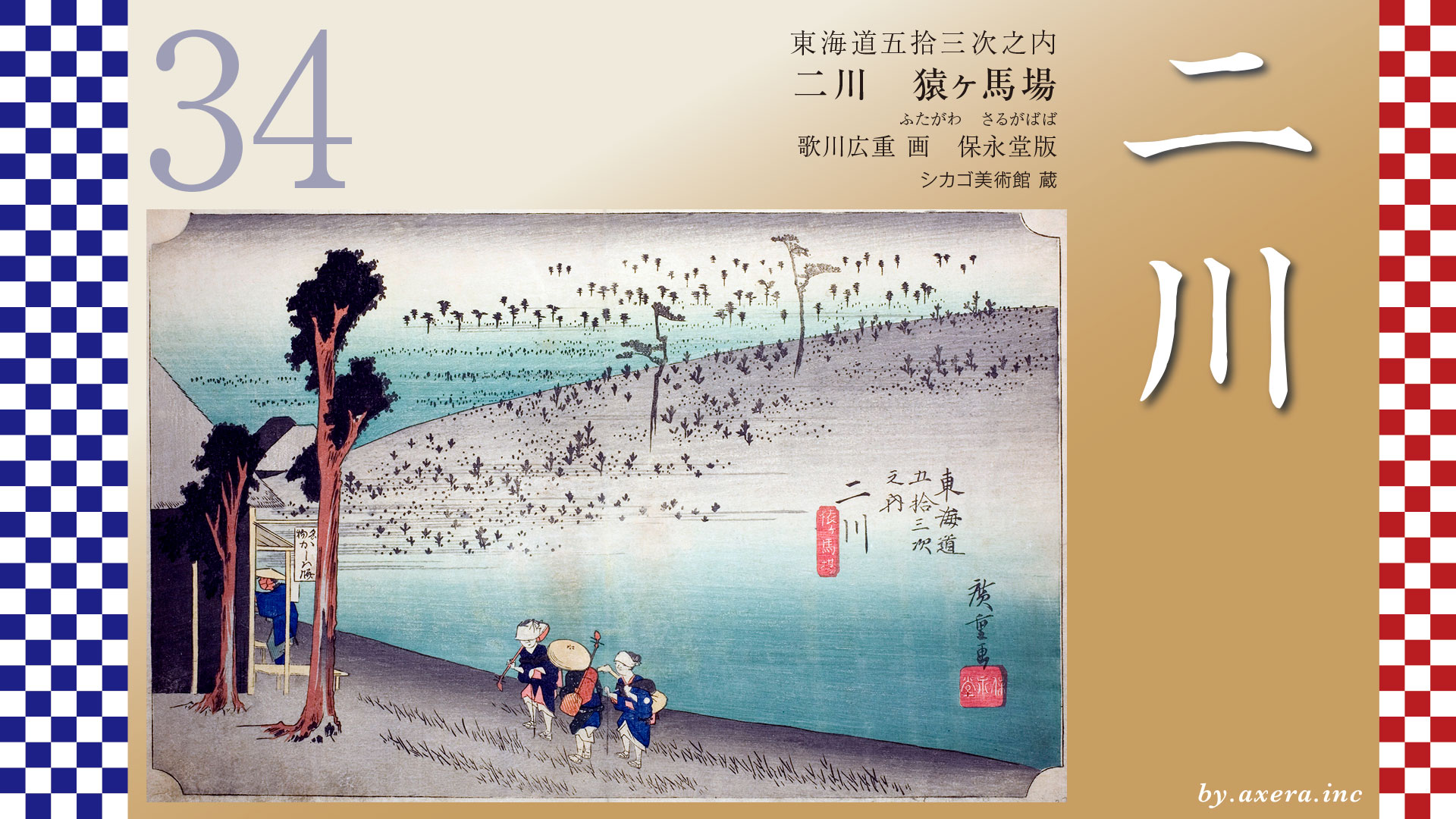
After walking a while, the pine trees lining the road at Okura appear, reminiscent of the Tokaido of that era.
Further along, you’ll see the Naito family’s nagaya-mon gate still standing on the right. This area was once the center of Shirasuka-juku. However, most of the houses were swept away by the Hoei earthquake and tsunami that struck in 1707. Consequently, the entire relay station relocated to higher ground up Shiozaka the following year.
Passing through this nagaya-mon gate, the entrance to Shiomizaka Slope comes into view on the right. It is believed that Hiroshige depicted the view seen from midway up this slope in his painting.
Hiroshige’s painting movingly depicts the Enshu Coast as seen from the top of a slope. Yet it’s fascinating how the daimyo procession in the foreground pays no heed to such a magnificent view, hastily descending the slope. After all, this stretch of the Tokaido was scarcely used by anyone other than official travelers like samurai and court nobles, so perhaps Hiroshige depicted the procession ironically to convey this fact.
On the slight hill to the right of this daimyo procession painting stood the “Fujimi no Matsu” pine tree. Travelers coming from the west would first encounter Mount Fuji through the pine branches upon reaching this spot. Thus, travelers from the west were moved by the sight of Mount Fuji and then exclaimed in wonder at the sea suddenly spreading out before them.
The coastline is depicted in detail, showing the roofs of fishing villages and brown nets laid out to dry. On the sea, numerous small fishing boats are visible in the foreground, while only the sails of the Benzaisen boats are depicted in the distance. The horizon is drawn as a straight line, as if drawn with a ruler, expressing the wide-angle perspective and the grandeur of the Enshu-nada.
The Reisho edition also depicts Shiomizaka, emphasizing the landscape with mountains relentlessly highlighted. Moreover, neither then nor now has there been any location along this stretch of the Tokaido featuring cliffs as steep as depicted in the painting.
The Gyosho edition is also Shiozaka, but it makes travelers who enjoy leisurely scenery happy. However, on the Tokaido’s Shiomizaka, there was no spot this open where you could see the sea.
The most open scene in the Poem edition depicts the Enshu Coast stretching out fully, with travelers resting leisurely at a teahouse. However, Shiomizaka lacks any open space suitable for a teahouse, and even near the top of the slope, the sea remains unseen.
Even upon close examination of the Hoeido edition of Shirasuka, there are numerous sections that suggest Hiroshige may not have actually seen the real scenery around this area.
I actually went to this Shiomizaka slope.
If you prioritize the direction of the daimyo procession depicted by Hiroshige and force yourself to look at Shiomizaka, it looks like this, and you simply cannot see the sea.
Shiomizaka slopes upward not parallel to the sea but with the ocean almost behind it, so this photo was taken after descending to a spot where the sea comes into view. It’s the view closest to Hiroshige’s painting, but I wish the sea were a bit more visible.
A photograph showing just a bit more of the sea would be closer overall to the scene Hiroshige painted, but the road the daimyo procession travels on would be completely invisible. Still, having actually walked all the way up this plateau with no view of the sea, I can’t help but think how truly moving it would be to have such a vista spread out before you.
This photograph was published in a reprint of a book issued in 1918. The scenery is almost the same as today, though there seem to have been fewer houses and trees back then.
Please view this image of the area from the sea side on Apple Street View.
The old Shirasuka-juku, located below Shiomizaka, was relocated to higher ground along with the entire station due to the Hoei earthquake and tsunami. However, according to records from the time this painting was created, Shirasuka-juku had a population of 2,700 people, 610 private homes, one honjin, one waki-honjin, and 27 ryokan inns, making it a medium-sized relay station.
But nowadays, many people wonder, “Where exactly is Shirasuka?”
During the Meiji railway planning phase, the steep gradient of Shiomizaka slope between Arai-juku in the east and Shirasuka-juku was deemed impassable for steam locomotives. Consequently, the route was rerouted via Washizu along the Hamana Lake coastline. That’s the light blue line. Furthermore, both the National Route 1 Hamana Bypass and the Shinkansen line opened while subtly bypassing Shirasuka-juku.
Having been spared such development, Shirasuka remains a quiet town that still retains parts of its Edo-period streetscape. Take a look at this pleasantly undulating, charming townscape.
The “suka” in Shirasuka means “a place where sand accumulates,” and indeed, the beaches in this area feature over 4 kilometers of pristine white sand brought by the Tenryu River.
The most famous attraction of Shirasuka was undoubtedly the magnificent view of the Enshu-nada coastline. Even today, Shirasuka Beach and Shio-mi Beach remain popular destinations.
Perhaps Hiroshige sought to convey in his painting of Shiozaka the awe that travelers walking from the west feel when the majestic Enshu-nada suddenly spreads out before them.
View the aerial image of this area ahead via Google Street View. I’ve marked the Tokaido route in orange. Looking down from above, you can see the present-day Shirasuka, which has weathered many dramas. From here, the Tokaido heads toward Futagawa-juku across the barren plateau.
コメント