

Fifty-three Stages of the Tokaido
Ishiyakushi
Ishiyakushi Temple
Hoeido edition, painting by Utagawa Hiroshige
The British Museum Collection
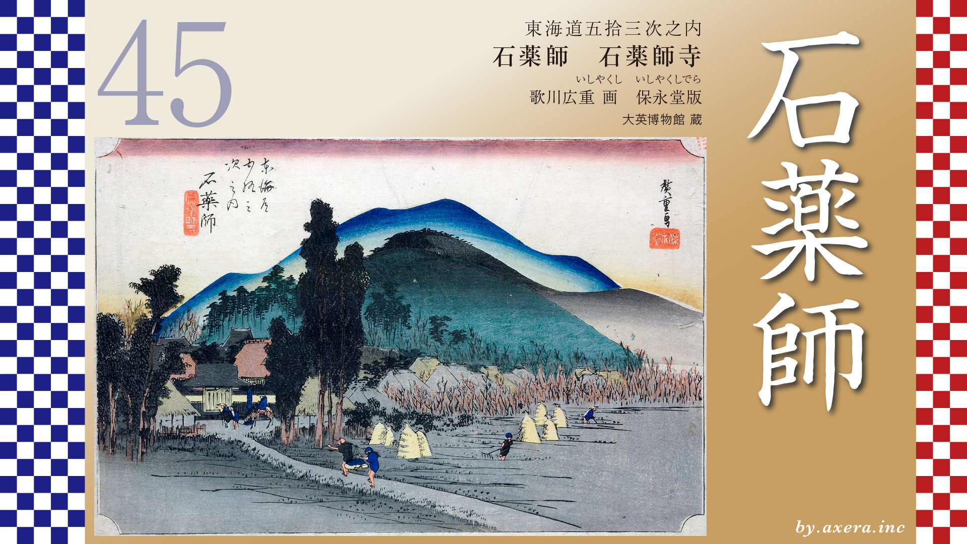
What you are looking at here is a scene depicting the precincts of Ishiyakushi Temple, from which Ishiyakushi-juku took its name, viewed across distant rice fields.Beyond this quiet rural landscape, the stage of history quietly reveals itself.
Let us begin by looking at a wider map.After leaving Yokkaichi-juku, the Tokaido runs about 10.8 kilometers to Ishiyakushi-juku.
Along the way, at the Hinaga crossroads, it separates from the Ise-kaido Road.
After passing this junction and walking about 6.5 kilometers, travelers reached Ishiyakushi-juku.
Continuing about halfway farther, they would already arrive at Shono-juku.
Ishiyakushi-juku officially became a relay station in 1616.
Because the distance between Yokkaichi-juku and Kameyama-juku was too long, a new relay station was established in Takatomi Village, which had developed as a temple town around Ishiyakushi Temple.
However, only eight years later, another relay station was built nearby at Shono, resulting in a concentration of small relay stations in this area.
At the time, the Tokaido near Hinaga was about nine meters wide.
Its sides were slightly elevated, and rows of pine trees welcomed travelers.
Today, only a single pine tree remains as a quiet reminder of those days.
Before long, travelers reached the junction where the Tokaido and the Ise-kaido Road diverged.
Here stood a torii gate for worshipping Ise Grand Shrine from afar, serving as a landmark for those on the road.
This is also the spot where the mochi shop was depicted in the clerical-script edition shown in the previous episode.
Farther along, travelers encountered Tsue-tsuki-zaka, a steep slope associated with the legendary hero Yamato Takeru.
Its sharp incline still conveys the hardships of travel in earlier times.
Eventually, the road merges with a national highway and then branches left again before entering Suzuka City.
After passing the honjin of Ishiyakushi-juku, travelers crossed National Route 25 and gently descended to the gate of Ishiyakushi Temple, which gave the relay station its name.
Because the Tokaido ran along the eastern edge of the temple grounds, Hiroshige is thought to have painted this scene from a slightly more easterly farm path.
On the map, Hiroshige’s viewpoint is indicated with a red gradient.
From his perspective, the scenery would have looked something like this.
On the left stands the temple gate, before which travelers and a monk head toward Shono.
On the right, a gentle slope leads toward Ishiyakushi-juku.
Along the paths, farmers carry loads, while others work in the rice fields.
It is a quiet autumn countryside, where the sounds of birds seem almost audible.
Though modest in appearance, it reflects a life sustained by steady labor.
The temple’s full name is Shingon-sect Takatomizan Rurikoin Ishiyakushi Temple.
Its principal image is a 190-centimeter-tall Yakushi Nyorai carved shallowly into natural granite, said to have been engraved overnight by Kobo Daishi Kukai.
During the Edo period, feudal lords traveling on sankin-kotai journeys prayed here for safe passage, and stone steps built for their use still remain today.
It is believed that Hiroshige drew inspiration from the illustrated guidebook “Tokaido Meisho Zue.”
When compared side by side, its influence is clearly visible.
Here again, Hiroshige’s viewpoint is marked in red.
The Reiso edition depicts the relay station’s Toiyaba, with its open-centered composition.
The Gyosho edition likely shows the area just before entering the town, covered in snow.
The Poem edition also portrays the Toiyaba and closely resembles the view of Fujieda-juku.
Now let us look at a wider satellite image.
The Tokaido, shown in orange, curves broadly from east to west, linking the relay stations along its route.
Most travelers from Edo turned onto the Ise-kaido Road at the crossroads beyond Yokkaichi.
Those coming from Osaka and Kyoto joined the route at Seki and continued toward Ise-betsu-kaido road.
During the Edo period, travel by common people was strictly regulated.
Passing through checkpoints required legitimate reasons.
Pilgrimage for religious purposes, however, was one of the few accepted exceptions, making travel permits easier to obtain.
In practice, even if travelers sought food or scenery, as long as they claimed religious devotion, the authorities were forced to allow it.
For this reason, pilgrimages to Ise became a major boom that supported traffic along the Tokaido.
During the 1830 Bunsei Pilgrimage, it is said that approximately 5 million people headed for Ise in just a few months. This is estimated to be about one-sixth of Japan’s population at the time.
Relay stations were obligated to support official government travel such as sankin-kotai.
However, these duties alone brought financial losses.
What sustained them were ordinary pilgrims who paid market rates for lodging.
Yet Ishiyakushi, Shono, and Kameyama largely missed out on these benefits.
Here is the view from nearly the same spot where Hiroshige once stood.
The road running left and right in front of the gate is the old Tokaido.
This photograph looks toward Ishiyakushi-juku from the temple gate.
The road rises to the left, crosses a bridge, and leads to the honjin.
Seen from above on Google Street View, Hiroshige’s perspective becomes clearer.
In his print, he added several large mountains behind the temple, though none actually exist.
These were likely included for compositional balance.
Looking farther ahead on Street View, Shono-juku soon appears beyond the temple.
The Suzuka River flows diagonally from the left.
Because pilgrims rarely passed through and Shono was nearby, Ishiyakushi-juku was used mainly as a rest stop.
Records show that it had only three honjin and fifteen lodging houses―the smallest on the Tokaido.
While the area around Ishiyakushi-ji Temple is now filled with many private homes, it was a fairly small village back then. Since they couldn’t make a living solely from lodging guests, most residents supplemented their income by farming. Their income came almost entirely from pilgrims visiting Ishiyakushi-ji Temple.
From the very start of its establishment, the village inn struggled with financial difficulties, perpetually operating on the brink of collapse. Consequently, due to its extreme hardship and the difficulty of maintaining the relay station, numerous petitions were submitted to the shogunate requesting subsidies and preferential treatment.
Today, this tranquil scene gives no hint of such struggles, yet a very real story lay hidden within this lonely Tokaido relay station, which was never a place of splendor.
コメント