

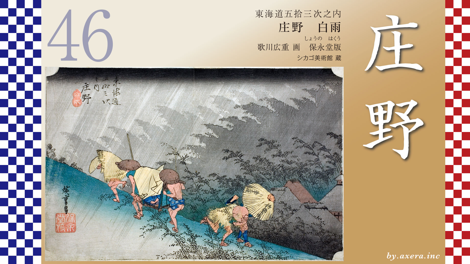
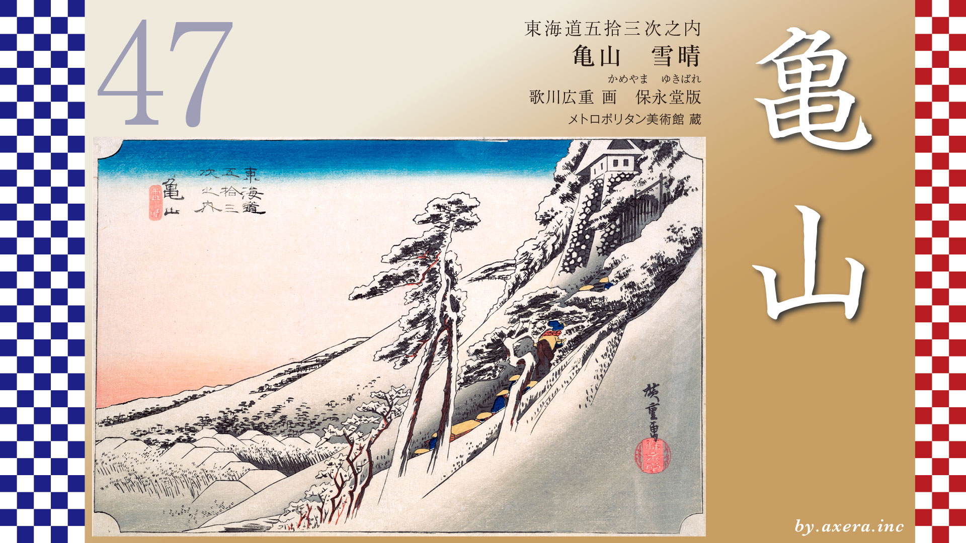
Fifty-three Stages of the Tokaido
Shono
Sudden Shower
Hoeido edition, painting by Utagawa Hiroshige
The Art Institute of Chicago Museum Collection
https://youtu.be/noUS48s5DEc
This scene portrays the moment when travelers along a mountain road are suddenly caught in a summer downpour and begin hurriedly running up a steep slope.
Amid the fierce rain and wind, the movements of the travelers are depicted with remarkable liveliness.
First, let us once again take a look at the somewhat unfortunate geographical position of Shono-juku using a wide-area satellite image.
On the right side, many travelers coming from Edo would leave the Tokaido at Oiwake, beyond Yokkaichi, and continue along the Ise Kaido, shown here in cream.
Meanwhile, travelers from Osaka and Kyoto also joined the route at Seki via the Tokaido or the Yamato Kaido, and from there proceeded toward the Ise pilgrimage along the Ise Betsu Kaido.
The pilgrimage to Ise sparked a great travel boom during the Edo period.
These pilgrims played a major role in supporting the development of the Tokaido.
However, Shono-juku, together with its neighboring Ishiyakushi and Kameyama-juku, stood along a comparatively quiet stretch of the Tokaido and was largely left out of these benefits.
For that reason, Shono-juku is said to have struggled greatly to maintain its relay station operations, much like Ishiyakushi-juku.
Here, please take a look at a map showing both Ishiyakushi-juku and Shono-juku.
After leaving Ishiyakushi-juku, the Tokaido continues for about 2.9 kilometers.
Measured from Ishiyakushi Temple, it is only a little over two kilometers to reach Shono-juku.
Moreover, about 1.5 kilometers before that point lies the location depicted in this print, “Sudden Shower.”Shono-juku was established in 1624.
Among the relay stations along the Tokaido, it was one of the latest to be created.The distance between it and Ishiyakushi-juku is also the second shortest interval between relay stetions on the entire Tokaido.
After leaving the town of Ishiyakushi, the Tokaido soon crosses the Gamagawa River.Beyond the bridge stands the Ishiyakushi ichirizuka milestone mound, and from there the road becomes a narrow route that almost resembles a path between rice fields.
Furthermore, from around the point where it crosses the Kansai Main Line, the old Tokaido no longer survives today as a roadway.
This is because, when the four-lane National Route 25 was later constructed, many of the original routes were altered or replaced.
Today, by turning right at the Kasadocho intersection on National Route 25 and proceeding along the side road, you can approach the place depicted by Hiroshige in “Sudden Shower.”
Continuing along the highway and turning right at the next traffic signal will bring you to the eastern entrance of Shono-juku.
However, part of the old Tokaido that once ran parallel to National Route 25 is now occupied by the grounds of a concrete factory.
Here, let us enlarge the map of this area a little.
Because both the roads and the course of the river in this region have changed significantly, we will also overlay another historical source.
This is an aerial photograph taken in May 1946 by the American forces stationed in Japan after the Second World War.
Since the present National Route 25 had not yet been built at that time, the original terrain is much easier to understand.
Here, the route of the Tokaido and the location of Shono-juku have been overlaid, and the place believed to represent Hiroshige’s viewpoint is indicated with an orange gradient.
The subtitle “Hakuu,” meaning “Sudden Shower,” refers to a summer downpour.
The print vividly depicts travelers suddenly caught in a heavy rainstorm, hurriedly running along a sloping road.
On the left side of the image, a traveler wearing a straw rain mat and a sedge hat rushes up the steep slope.Just behind him, a palanquin bearer climbs the hill, supporting himself with a staff while carrying a passenger sheltered beneath a rain cloak draped over the palanquin.
Further to the right, a farmer wearing a straw raincoat and holding a hoe leans forward as he descends the slope, pressing down his sedge hat against the strong headwind.
Behind him, another traveler walks down the hill under an umbrella.
A traveler wearing blue leggings struggles against the gusts, descending the slope while holding his umbrella only half open.From the arrangement and movement of these figures, one almost feels as if a voice were calling out from beyond the scene―“Hey, it’s raining!”
The trees in the background bend dramatically in the strong wind, and the rain lashes almost at a right angle across the slope.
Even compared with the height of the nearby houses’ roofs, it is clear that this road runs along a considerably elevated ridge.
Incidentally, impressions in which the half-open umbrella bears the publisher’s marks reading “Takenouchi” and “Fifty-three Stations” are said to be prints close to the earliest edition.
This is an old photograph of the same location, published in a photo collection titled Tokaido in 1918. This area was once called Takamiya, and there stood a well-known teahouse called “Okon Chaya.” It is believed that Hiroshige may have depicted the area around this teahouse.
“Okon” was the name of the young woman who worked there. She was said to be so beautiful that travelers along the Tokaido spoke of her wherever they went. However, she passed away in 1832, and later the teahouse itself was swept away in a flood in 1896.
On the right side of the photograph, a well believed to mark the former site of the teahouse still remains. Further behind it, what appears to be a railway line can also be seen.
The Reisho edition depicts travelers, porters, and a monk warming themselves by a fire along a narrow field path just before entering Shono-juku.
In the Gyosho edition, the scene shows the relay station office in Shono-juku, where horses and porters were dispatched for travelers.
Originally, Shono-juku was required to provide one hundred porters and one hundred horses. However, because the number of travelers was small and the town struggled financially, the authorities petitioned the shogunate, and by 1758 the number had been reduced to thirty porters and twenty horses.
The Poem edition depicts the ichirizuka milestone mound that once stood opposite Kawamata Shrine at the western end of Shono-juku.
A large hackberry tree served as its landmark.
Now, let us take a look at the actual location.
Standing here today, what you see are mostly roads and guardrails.
And rather than a steep slope, the road even seems to tilt slightly in the opposite direction.
Whether this is the result of modern road reconstruction, or perhaps an artistic exaggeration by Hiroshige, remains uncertain.
However, since this area tends to accumulate river gravel, it is possible that the ground stood slightly higher in those days.
Moving a little further forward, the view opens up.
Although it is not the dramatic slope depicted by Hiroshige, the surroundings somehow evoke the feeling that the famous Okon Chaya might once have stood nearby.
Ahead, you can see the tracks of the Kansai Main Line.
Beyond them are the groves of trees depicted by Hiroshige, along with part of the old Takamura settlement.
This is a Google Street View image taken from above the area, looking westward.
Although the old Tokaido itself no longer survives, the presumed route has been marked here in orange.
In the distance, the mountains of Suzuka can be seen.
Here as well, Hiroshige’s viewpoint has been overlaid with a gradient.
And here is the eastern entrance to Shono-juku, reached by following the old Tokaido.
At that time, this was a small relay station where travelers were few and far between.
There were only fifteen inns, and the village population was less than a thousand.
On the outskirts stood a single teahouse run by a beautiful young woman.
Such was the quiet and simple life that once continued here.
Even today, Shono retains a remarkably calm and peaceful townscape.
When you walk through it, there is a curious sense of relief that settles in your heart―
as if a gentle and timeless atmosphere still flows quietly through this place.
コメント