
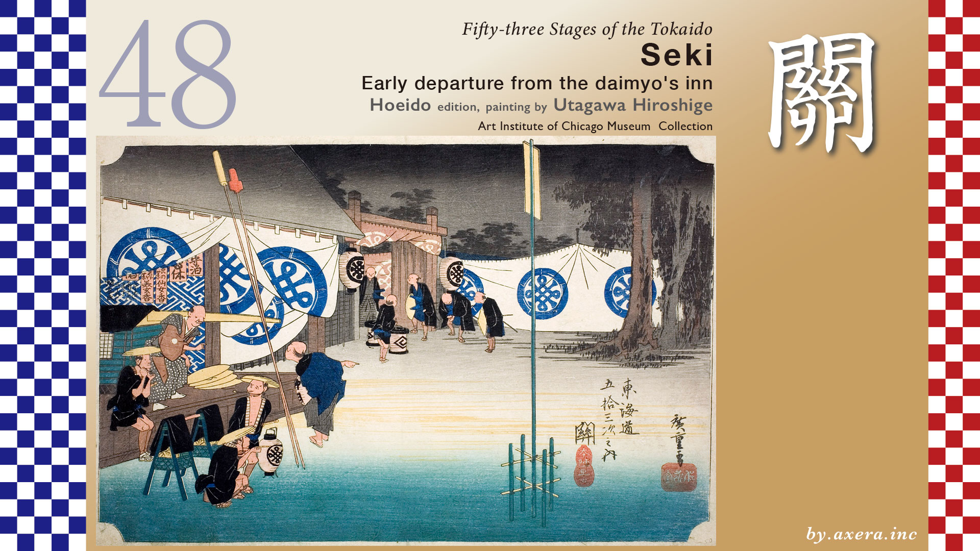
Fifty-three Stages of the Tokaido
Seki
Early departure from the daimyo’s inn
Hoeido edition, painting by Utagawa Hiroshige
Art Institute of Chicago Museum Collection
Before dawn—when the sky has not yet fully begun to brighten.
Utagawa Hiroshige depicted a daimyo about to depart from the honjin, and the people busily working to prepare for it.
After leaving Kameyama-juku, following roughly along the north side of the left bank of the Suzuka River, you arrive at Seki-juku in about 5.8 kilometers.
After passing through the Kyoguchi-mon Gate, descending a steep slope, and crossing a small stream, the Nomura ichirizuka milestone soon appears.
It still strongly retains its appearance from that time.
Continuing further, a small Shirakawa guidepost appears, and beyond that the road becomes a long straight stretch.
This road is a historic field path called Ookadera Nawate, said to be the longest along the Tokaido.
Even now, the straight road continues for over two kilometers, and guide signs have been installed.
Moving slightly away from the Suzuka River and crossing its tributary, the Ono River, a descending path to the left and a torii gate at its entrance come into view.
This is the eastern junction of Seki-juku, the branching point with the Ise Betsukaido.
Passing through the torii and going left here, it once joined the Ise Kaido at Edobashi.
Beyond that, one could travel to Ise via the castle town developed by Todo Takatora, then called Anoutsu, present-day Tsu City.
Proceeding further west from here, the streets of Seki-juku begin, and even today the Tokaido, evoking the townscape of the Edo period, continues for about 1.8 kilometers.
The western end of Seki-juku becomes the western junction, where it branches with the Yamato Kaido.
Taking the Yamato Kaido to the left, one could travel via Iga Ueno to Nara.
Further to the north lies the remains of the Suzuka Barrier checkpoint.
It is one of Japan’s three ancient checkpoints recorded since antiquity, and a place that also gave rise to the name Seki-juku.
Now, let us take a closer look at Hiroshige’s picture.
From the fact that the trees in the background are sunk in darkness, we can tell that it is still before dawn.
In the left foreground are three men.
They have already prepared for travel and even show the composure to smoke their pipes.
One of them carries baggage, while the other two handle spears, which are wrapped in red and yellow covers and leaned against the roof.
In the back stands the master of the honjin, giving instructions to a man holding a lantern.
At the gate, samurai with sword covers attached to their hilts slightly bend forward, as if waiting for someone’s departure.
Such detailed depictions of figures give the scene a quiet sense of tension.
The light blue mark on the curtains spread throughout this picture seems to be a design of “Tanaka,” said to be the name of Hiroshige’s paternal family.
The mark on the box lantern in the center is a design of Hiroshige’s katakana “Hiro.”
The hanging slips on the far left reading “Senjoko” and “Bigenko” are said to be face powder and hair dye, products sold by the sponsor.
To their left, though difficult to read, it says “Mr. Sakamoto, Kyobashi Minami Tenma-cho 3-chome.”
This Mr. Sakamoto was the maker of “Senjoko” and “Bigenko,” and seems to have been a sponsor of this series, contributing some advertising fees.
It is interesting that advertising already existed from such times.
This name appears several times within the series.
The Reisho edition depicts a snowy scene at the eastern junction of Seki-juku, where the road branches off to the Ise Betsu-kaido.
The red torii and lantern are symbols of the Ise Grand Shrine.
In the Gyosho ediotion, it is an evening scene at an inn.
The figure of an old woman pulling at a traveler’s sleeve gives a sense of human warmth.
In the Poem edition, people are seeing off a departing daimyo.
Their uniformly formal posture is somewhat charming.
Katsushika Hokusai depicted famous places a little further beyond Seki-juku.
On the way to Sakanoshita-juku, there were well-known rocks with interesting shapes called Ebisu Rock and Daikoku Rock.
According to the Tokaido Meisho Zue, there were also Kannon Rock and Meoto Rocks.
I actually visited this place.
The Ito Honjin depicted in Hiroshige’s work no longer exists and only the site remains, but the townscape still retains an atmosphere that evokes that time.
Also, speaking of Seki-juku in the Edo period, the summer festival was famous.
It was a festival known in the surrounding regions, so famous that it was spoken of alongside Kansai’s Gion Festival and Tenjin Festival.
At its peak, as many as 16 floats paraded through the narrow streets of Seki-juku, and the phrase “seki no yama,” meaning “the utmost limit,” is said to have originated from this.
Because the Yamato Kaido branched at the western junction and the Ise Betsu-kaido at the eastern junction, Seki-juku was bustling with people traveling along these roads.
It also flourished greatly throughout the Edo period as a key transportation hub for sankin-kotai and pilgrimages to Ise.
However, after the Meiji Restoration, both the present JR Kansai Main Line, opened in 1890, and later National Route 1 were built away from the old Tokaido.
Thanks to this, Seki-juku alone preserved more than 200 old townhouses built from the Edo to Meiji periods within this town.
While most post towns along the old Tokaido have not retained their original state, Seki-juku alone preserves its historical streetscape, and in 1984 about 1.8 kilometers between the eastern and western junctions was designated as a national Important Preservation District for Groups of Traditional Buildings.
The plots of the townhouses are narrow at the frontage and long in depth, forming a strip-like shape.
The main house of each stands facing the Tokaido, and behind it, corner buildings, detached rooms, storehouses, and sheds are arranged in a long, linear layout.
Based on this photograph, I tried to recreate the appearance of Seki-juku of that time using AI.
At that time, many travelers enlivened this townscape.
Using the same AI, I also had it create an image of an early morning departure of a daimyo procession like Hiroshige’s.
Influenced by the images I took, the composition is quite different from Hiroshige’s, but you can still sense the morning atmosphere.
Please take a look ahead using Google Maps Street View.
The Tokaido leaves behind the townscape retaining the scent of Edo, proceeds westward from the western junction along Route 1 into the mountains, and heads toward the Suzuka Pass, known as a difficult section.
Turning left at the junction leads onto the Yamato Kaido, crossing the Suzuka River and continuing through mountainous paths roughly along Route 25 toward the Iga Ueno area.
コメント