
Fifty-three Stages of the Tokaido
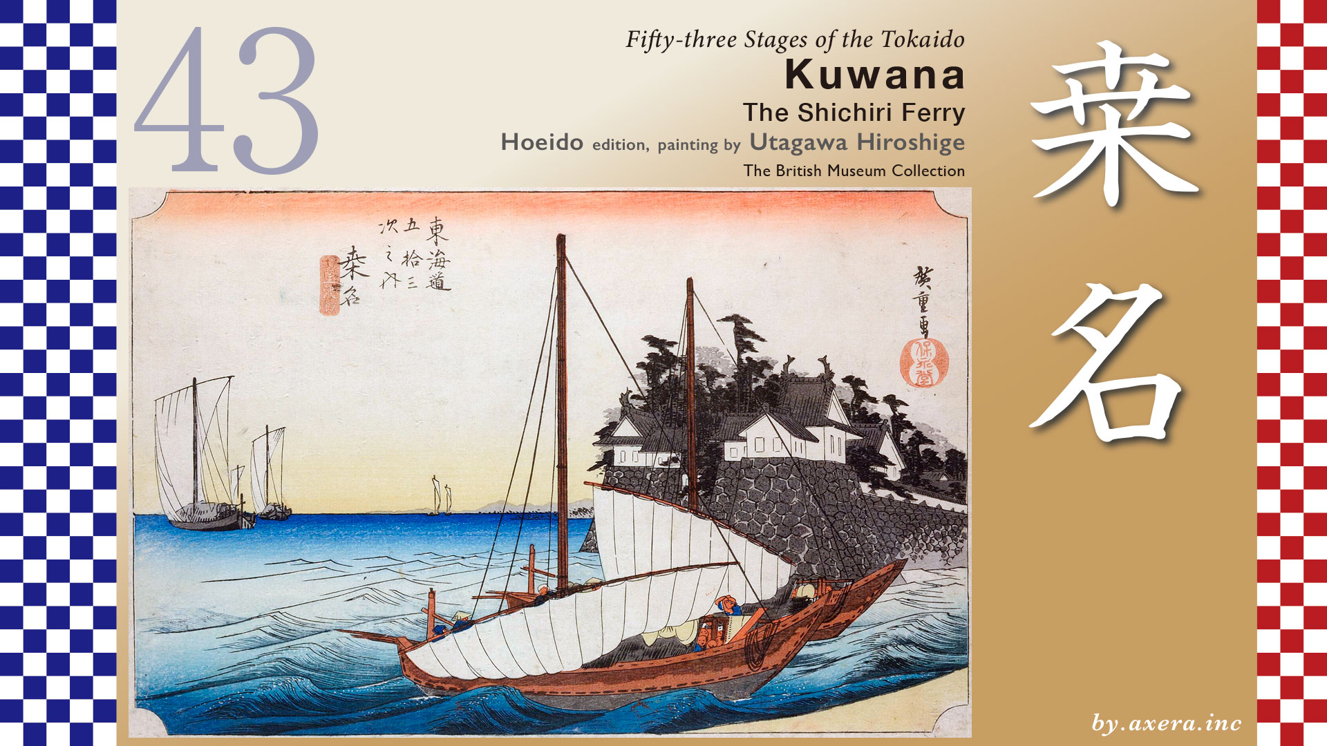
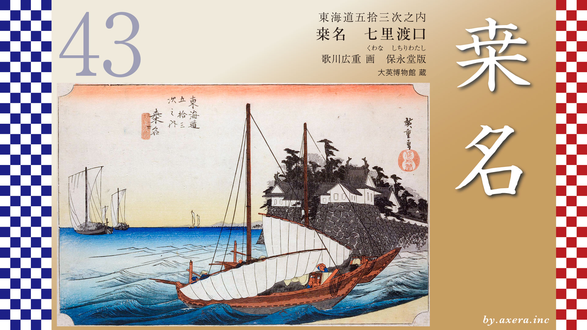
Kuwana
The Shichiri ferry
Hoeido edition, painting by Utagawa Hiroshige
The British Museum Collection
This work depicts a boat that has crossed the Shichiri-no-Watashi and is just about to arrive at the port of Kuwana.
The subtitle is read Shichiri-watashi.
From Miya-juku to Kuwana-juku along the Tokaido, the distance was seven ri―more than approximately 27 kilometers.
Rather than traveling this distance overland, travelers were required to cross Ise Bay by boat.
If we look at a modern map, most of this route has already become land, but in the past it was an expanse of open sea and wetlands.
According to records from the early Edo period, the coastline at that time lay roughly to the south of the present-day Kintetsu railway line.
However, it was not a clearly defined shoreline; instead, the area consisted of an intricate and highly unstable landscape of vast tidal flats and marshes.
Now, let us overlay the coastline from the late Edo period, the era of Hiroshige.
The areas shown in green represent the approximate landmass of that time.
It becomes clear that the Shichiri-no-Watashi―seven ri ferry route ran across the sea while carefully avoiding these land areas.
This seven ri ferry service began in 1616.
At high tide, the boats followed a route close to the shore, covering about seven ri ―27 kilometers.
At low tide, however, they took a wide offshore route that extended to ten ri―approximately 39 kilometers.
The journey took between four and six hours.
When weather conditions were favorable, travelers reportedly enjoyed the voyage as if it were a leisurely sightseeing cruise, taking in the maritime scenery.
Once out at sea, travelers could see the keep of Nagoya Castle and the mountains of Kiso to the north.
They crossed major rivers such as the Kiso River and the Ibi River, and under ideal conditions, they could even glimpse Mount Asakuma in Ise, Futami-ga-ura, and as far as the port of Toba to the south.
Approximately 75 boats were in operation.
According to a record from 1711, the fare to Kuwana was 45 mon per traveler.
When converted into modern terms based on the daily wages of Edo-period craftsmen, this amounts to roughly 2,300 yen.
The darker green areas indicate land and wetlands from the early Edo period, while the lighter green areas represent those of the late Edo period.
Over the span of roughly 260 years, an enormous amount of sediment accumulated.
At the same time, the Shichiri-no-Watashi was known as one of the most dangerous sections of the Tokaido, where sudden weather changes often led to maritime accidents.
To avoid these dangers, travelers chose an alternative route known as the Saya Kaido.
Before reaching Miya-juku, the road turned right at Kamichikama Shrine, passed along the western side of Atsuta Shrine, and headed toward the Kiso Kaido.
At one point the route branched left to become the Saya Kaido, crossed what is now the Higashi-Meihan Expressway, and continued westward.
Eventually, it reached Saya-juku, located between present-day Yatomi and Tsushima in what is now Aisai City, where travelers arrived at the Kiso River.
From there, they crossed to Kuwana via the Sanri-no-Watashi, the route indicated by the green line on the map.
The Saya Kaido was about two ri―roughly 8 kilometers―longer than the Shichiri-no-Watashi and cost approximately 2.5 times as much.
Nevertheless, it was used even more frequently.
The reason was not only to avoid maritime disasters.
Travelers also wished to enjoy the journey itself: “If we have come all this way, we want to see the golden shachihoko of Nagoya Castle and visit Tsushima Shrine.”
Such sentiments drew people to this route.
Please look at the enlarged map of the Kuwana-juku area.
Kuwana-juku, where both the Shichiri-no-Watashi and the Sanri-no-Watashi arrived, had as many as 120 inns.
In terms of the number of lodgings, it was the second largest juku on the Tokaido, surpassed only by Miya-juku.
Kuwana Castle was developed beginning in 1601 under Honda Tadakatsu, one of the Four Heavenly Kings of Tokugawa and renowned as a master spearman.
Along the Ibi River, castle structures, boat landings, a four-tiered, six-story main keep, and a total of 51 turrets were constructed, along with a well-planned castle town.
It came to be praised as a famous “water castle.”
By the time Hiroshige painted this work, the castle lord was Matsudaira Sadaaki, the younger brother of Matsudaira Katamori, lord of the Aizu Domain.
As a result, many buildings were lost during the fighting of the Boshin War, and the vitality of the town declined as well.
Here, Hiroshige’s viewpoint has been indicated with a red gradient.
This image shows Kuwana as depicted by Hiroshige II.
For travelers who had safely crossed the Shichiri-no-Watashi, the first structure to catch their eye was the Banryu Yagura―Dragon Turret, shown at the center.
With this in mind, let us now look at Hiroshige’s print.
Two boats, with the port of Kuwana just ahead, are lowering their sails and preparing to switch to oar propulsion.
In the left background is a large benzaisen cargo ship, and beyond it, the towns of Yokkaichi and Tsu can be seen.
On the right stands the Banryu Yagura―Dragon Turret of Kuwana Castle.
Seeing this turret signaled that one had arrived in Kuwana.
The stone walls, strong enough to withstand both tides and river currents, convey a sense of formidable solidity.
After such a long journey by sea, one can almost hear voices exclaiming, “At last, we have reached Ise Province.”
In reality, passengers boarded and disembarked by passing beneath this Banryu Yagura turret, where a stepped gangi was constructed toward the Ibi River in the far right rear.
Immediately upon landing, travelers encountered the Torii Gate for the remote worship of Ise Grand Shrine.
They could not help but feel that they had entered Ise Province and that the sacred destination of Ise lay close at hand.
Notably, the sandbar of the Ibi River depicted in the lower right corner of the print is remarkably realistic.
When we look at the Ise Sangu Meisho Zue, said to have been a reference for Hiroshige, the structure of Kuwana Port becomes clear.
On the right is the Banryu Yagura turret, at the center the landing steps, and in front of them the Torii Gate.
Viewed through present-day Google Street View, the entrance appears somewhat narrower, but the basic structure of the historical port can still be recognized.
In the Reisho edition, the scene depicts travelers leisurely enjoying the sea route.
Some stretch their arms, others lean on the gunwales while admiring the northern scenery, and women and monks are also shown.
The boat approaching from the left is a merchant vessel selling food to passengers aboard the Shichiri-no-Watashi.
In the Gyosho edition, the building with the shachihoko ornament in the foreground is the Banryu Yagura.
To its left is a boat about to raise its sails and head out to sea.
The countless vessels gathered around the landing steps and Torii gate convey the bustle of the port.
The Poem edition depicts the rest stop at Tomida, just beyond Kuwana.
Speaking of Kuwana, one cannot overlook its famous grilled clams.
Known since the Edo period for their excellent flavor, they were an essential specialty for travelers on the Tokaido and an important source of income for the Kuwana domain.
In Hokusai’s Tokaido series, the scene of grilling these clams is depicted, complete with rising smoke between two women.
The three Kiso rivers―the Ibi, Nagara, and Kiso―formed vast wetlands in this area at the head of Ise Bay, creating one of the most difficult sections of the Tokaido.
At the same time, they carried rich nutrients from the mountains, nurturing fertile seas and providing abundant marine resources such as clams, freshwater clams, and icefish.
Kuwana’s clams in particular reached an annual catch of 3,000 tons in the 1960s, ranking among the best in Japan in both quality and quantity.
However, due to the loss of tidal flats and environmental degradation, catches declined sharply.
In 1995, when full operation of the Nagara River Estuary Weir began, the catch fell to a record low of just 0.8 tons.
In response, fishermen, alarmed by the crisis, spent half a century undertaking environmental restoration efforts such as the creation of artificial tidal flats.
As a result, clam catches recovered to 200 tons by 2012.
On the other hand, after the Tokuyama Dam upstream on the Ibi River began operation in 2008, freshwater clam catches declined drastically.
One reason is believed to be the reduced supply of sand essential for their survival.
This is the present-day Kuwana Port as seen on Google Street View.
At the center stands the reconstructed Banryu Yagura―Dragon Turret, and beyond it, Nagashima Spa Land can now be seen.
The scenery on the left, once entirely sea, has changed dramatically.
This view shows the area where travelers would turn back after landing.
The reconstructed Banryu Yagura can be seen beyond the bridge.
Shifting the viewpoint slightly to the left, one sees the large Torii Gate of Ise Grand Shrine and stone lanterns.
Moving closer to the embankment and viewing the torii gate together with the Banryu Yagura, the remains of the landing steps appear in the foreground.
Upon landing at Kuwana Port, marked by the Banryu Yagura―Dragon Turret, travelers immediately encountered the Torii Gate for the remote worship of Ise Grand Shrine and sensed that they had entered Ise Province.
Looking ahead in Google Street View along the orange-marked Tokaido, we see that what was once a dangerous yet bountiful sea on the left in the Edo period is now lined with roads and buildings extending toward the water.
Although the recovery of clams and freshwater clams remains incomplete, waves of development continue to press in relentlessly.
Please take a look at the map drawn around 1859.
It clearly shows the landscape shaped by the Kiso Three Rivers, as well as the development and destruction that followed the Meiji Restoration.
The symbol of Kuwana, the Banryu Yagura―Banryu meaning “a dragon still coiled on the ground, not yet ascended to the heavens”―derives its name from legend.
It is said that a dragon once lived in the moat of Kuwana Castle and possessed mysterious powers.
The Tokaido, gently winding through this “city of the coiled dragon,” continues onward through Ise Province toward Yokkaichi.
コメント