
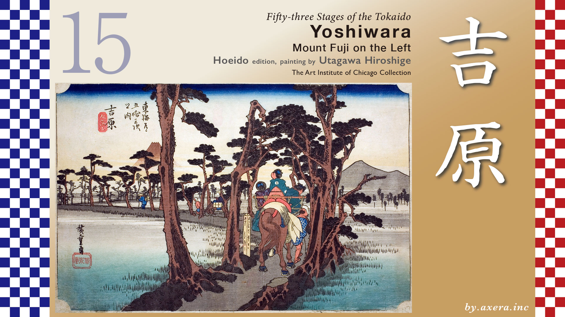
There were two spots on The Tokaido where Mt. Fuji could be seen on the left side of the road from Edo to Kyoto, instead of on the right. One is “Left Fuji of Nanko” in Chigasaki and the other is here in Yoshiwara. The reason is that in both cases, the road turns largely to the north, and Mt. Fuji is temporarily visible on the left.
The distance from Hara-juku to Yoshiwara-juku is about 12.5 km, which is not a mountain road, but it is quite a distance.
Ukishima Swamp, called Ukishima-gahara at that time, should also be included in the map in a thin layer.
The Tokaido crosses the Tokaido Line after leaving Hara-juku and joins the Senbon Kaido around Higashi Kashiwabara.
Around Higashi Tagonoura Station, there was an Aino-shuku, and a little further on, crossing the Hironuma Bridge, there was an Ichirizuka in Numata Shinden.
Just before JR Yoshiwara Station, The Tokaido turns sharply to the right and passes under the tracks of the Tokaido Line.
Then pass through the north side of Yoshiwara Station and cross the Numa River.
A little further on, before the Yoda Bridge, you will pass under the Shinkansen and the bypass, which is like a three-way intersection if you are coming from the east, and The Tokaido is the one-way exit in the middle of the road. After crossing here, the road gradually turns to the right and you will temporarily see Mount Fuji on your left. Fuji can be seen in front of the road from the next traffic light, if you are lucky.
After crossing the Left Fuji, follow the road to Gakunan Railway’s Yoshiwara Honcho Station, which is approximately where Yoshiwara-juku becomes the center of Yoshiwara relay station.
The Tokaido’s Yoshiwara-juku was divided into the Kami-kaido, the main road of the Tokaido, and the Shimo-kaido, the old road. The Honjin was located at the rear of the road, and if you went straight ahead, you would reach Kofu via Fujinomiya on the Nakamichi Oukan, also known as the Nigai Kaido because of the name of a specialty of Kofu. If you went to the right at Yoshiwara-juku, you could pass through Gotemba on the Juriki-michi road. So it was also a strategic point of traffic where various roads intersected.
The Yoshiwara-juku began at Yoshiwara Minato, located on the southwest side of what is now JR Yoshiwara Station. Today’s Tagonoura Port was once called “Yoshiwara Minato” and was a river port on the Yoshiwara River, not a large inlet-like port as it is today. Here, in the Kamakura period, Minamoto no Yoritomo placed a mitsuke on the Suzukawa and created a route to cross by boat to Maeda Village on the opposite bank of the Yoshiwara River.
340 years later, around 1555, the village was moved to the southeast side of Yoshiwara Station due to tsunami and sand drift, and the name of the juku was officially established as “Yoshihara” at that time. This is the Moto-Yoshiwara. In the early days, the Tokaido route went straight through Yoda-bashi Bridge, following the path of the road.
However, this site was also devastated by a tidal wave in 1639, and to prevent a recurrence, it was later relocated to the west of where Left Fuji can be seen, to a place called Naka-Yoshihara.
However, in 1680, Naka-Yoshiwara was again devastated by a tidal wave, and was relocated further inland to the present-day Yoshiwara Honcho area. The Tokaido, which had run along the sea from Hara-juku to Yoshiwara-juku, now turned sharply to the north, with its back to the sea, in front of Yoshiwara-juku. Fuji, which had previously been visible on the right, was now visible only 300 meters to the left, giving rise to the famous sight known as “Mount Fuji on the Left”.
Here is an Applemap street view to see the topography.
Considering the mechanism of storm surge, the very deep water of Suruga Bay increases the “suction effect” of low pressure. The topography of Suruga Bay, which is narrow in depth, also increases the “blowing-in” effect of strong winds. Fuji eruption, sand drift, land subsidence, and other natural disasters. These factors pushed the Yoshiwara-juku, located at the deepest part of Suruga Bay, further and further inland.
Let us take a closer look at Hiroshige’s painting.
In the painting, beside the Bojikui-marker stakes marking the entrance to the Yoshiwara-juku, three boys are depicted riding on horses along a row of pine trees. Only the last one notices Mt. Fuji on the left and looks in that direction. It seems as if Hiroshige intended to show Fuji.
As in this painting, three children are mounted on a horse with a wooden frame, which is called “Sanpo-koujin,” meaning Koujin-sama, the god of the hearth, and is an image of the Sanpo of the Shinto ritual utensils. It is said that during pilgrimages to the Ise Shrine, there was a combination of an adult in the middle and a child on each side.
In addition, horses carrying children wore straw sandals, which was not uncommon in those days, and there were also straw sandals specially designed for horses to protect their hooves. For this reason, the horsemen carried both their own straw sandals and those of their horses with them at all times.
The Reisho edition also depicts Left Fuji, but the way it looks is a bit exaggerated. The travelers on horseback are not traveling toward Kyoto, but toward Edo.
The Gosho edition depicts a teahouse serving “Yamakawa no Shirozake, which was also a specialty of the Yoshiwara-juku. Beyond Yoshiwara-juku, in the area north of today’s JR Fuji Station, there was a Ai-no-juku called Motoichiba, where white sake was a specialty. The name “Yamakawa no Shirozake” does not refer to the name of the place, but to the fact that “the water of the river flowing through the mountains looks white when it foams up,” and so White-sake was called “Yamakawa no Shirozake,” as in the common phrase.
Poem editin still depicts Left Fuji, but the main focus is on Mt. Fuji, not people. The curves along the Nawatemichi are almost the same as the real The Tokaido.
Hokusai’s Fifty-three Stories also depicts the process of making White-sake, a specialty of the Yoshiwara-juku. Near the Fuji River, glutinous rice was grown extensively, and White-sake made from it was a specialty. Today, it has been restored in the Yoshiwara area as “Yamakawa no Shirozake” and is sold as muddy sake.
I went to this place, where Mt. Fuji can be seen on the left between the beautiful pine trees. Now, the pine trees and the ridge between rice fields had been turned into factories and private houses. It is a little disappointing that on this day we could not see to the top of Mt.Fuji.
Looking at photos taken around 1918, it seems that the rows of pine trees were still in good shape.
I took a look at this area with Google MAP Street View.
The Tokaido in orange color is covered over it. The Nawate-michi, or Tambo-michi, which Hiroshige painted, is nowhere to be found, and there are buildings all the way up to the Fuji River.
What you see in this photo is almost the fan-shaped area of the Fuji River flowing from the right. Since ancient times, the Fuji River has been actively changing its flow to the area around Yoshiwara-juku, repeatedly overflowing and depositing sediments.
I will add Hiroshige’s viewpoint to this in red gradient. Yoshiwara-juku, which had to be relocated many times to escape repeated high tides and disasters, gave birth to a famous place with a slightly different flavor, Mount Fuji on the Left. It too has now become a calm and normal town.
The Tokaido, which for a time showed Mt. Fuji to the left, has largely turned to the west, passing north of Fuji Station ahead and heading toward the Fuji River flowing from Koshu.
コメント