
Fifty-three Stages of the Tokaido
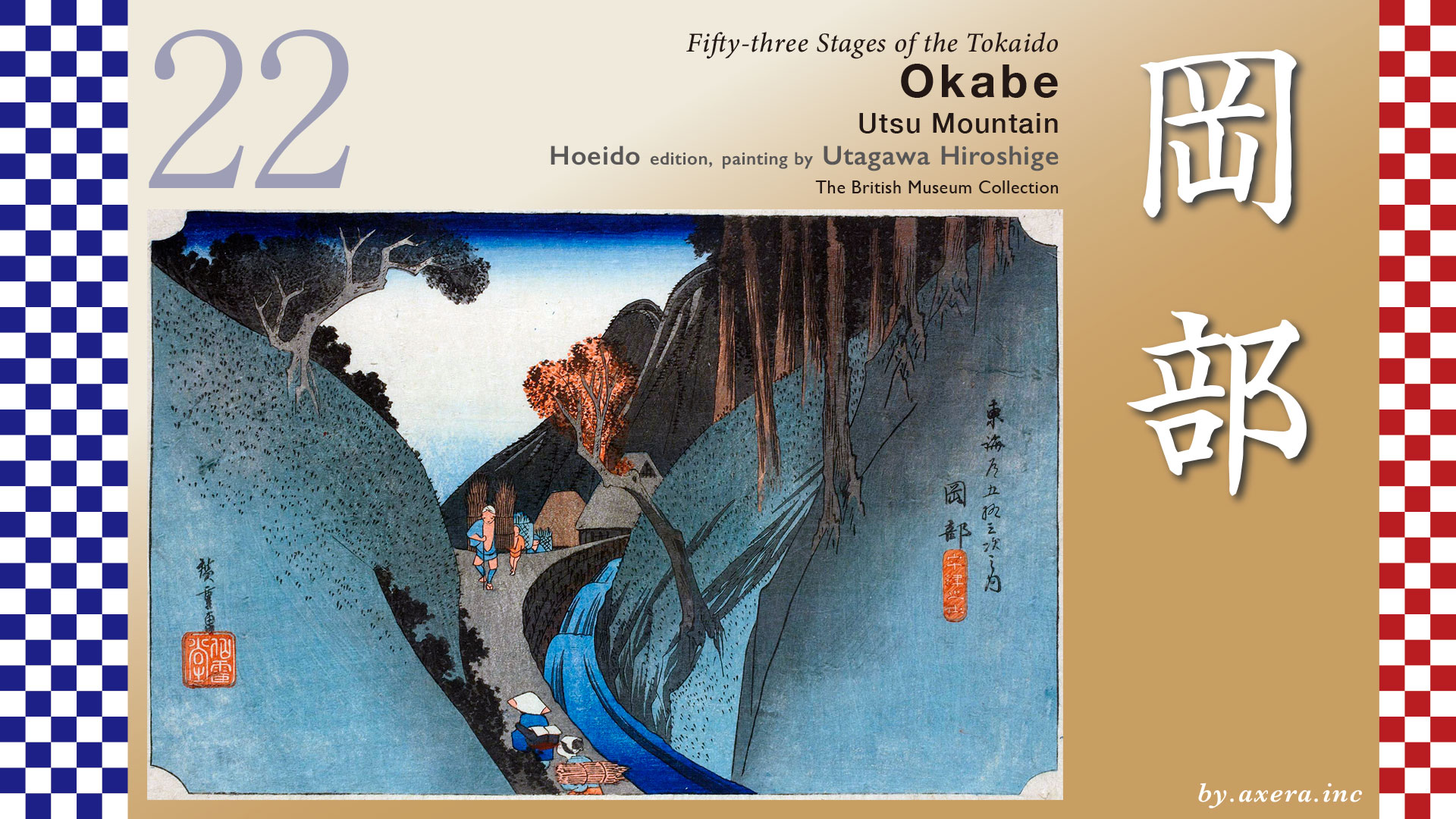
Okabe
Utsu Mountain
Hoeido edition, painting by Utagawa Hiroshige
The British Museum Collection
This painting of Okabe-juku depicts people ascending and descending a slope against the backdrop of the Utsunoya Pass, which was known as a difficult place to pass.
Okabe-juku is about 8 km over the mountains from Mariko-juku, the previous inn, and the point where Hiroshige painted this picture is thought to be about 2/3 of that distance.
Crossing the Mariko River from Mariko-juku, The Tokaido continues on the south side of the river for a while. Eventually, Utsunoya comes into view at the far end of the front.
The Tokaido actually follows National Route 1, but is cut off here and there due to road construction. The Tokaido is now located around the truck parking lot of Michi-no-Eki Utsunoya Pass uphill. After passing this point and crossing the Maruko River at the Tsuta Bridge, you will see a path to the left that leads up into the mountains. This is the old road, “Tsuta no Hosomichi”. It is shown in green on the map.
I covered this with a map showing the difference in elevation.
This “Tsuta no Hosomichi” was an old road from the Heian period, but it was a little too steep for Toyotomi Hideyoshi to pass through with his large army on his way to attack Odawara. Therefore, he had a new pass road built on the west side. In the Edo period, it became the official The Tokaido, and Mariko and Okabe juku were established before and after the Utsunoya Pass.
The Tokaido crosses the Mariko River just before the pass and passes through the village of Utsunoya, which is also an intermediary juku. From this point onward, the road climbs up a serpentine slope to the pass.
The Tokaido is now a narrow mountain road that is impassable by car in the area of the pass.
After descending the mountain, the path becomes a little more open and joins “Tsuta no Hosomichi” path around Sakashita Jizo-do, and continues to the point where Hiroshige painted the picture.
Here is a closer look at Hiroshige’s painting.
Utsunoyama is seen in black in the far front. In front of it are only a few houses, and a group of lumberjacks carrying many bushes are walking ahead. To the right, a river is flowing swiftly, and from this direction, travelers and villagers carrying brush on their backs are walking up a narrow path. The entire painting is based on blue and black, giving the impression of a dark mountain pass.
The Reisho edition depicts a traveler going down toward Okabe-juku after crossing the Utsunoya Pass.
The Gyosho edition depicts a teahouse in tateba that sells the specialty “too-dango” at a teahouse near the pass.
To keep away demons that would appear at the Utsunoya Pass, “too-dango” were made by making a series of 30 bean-sized dumplings and bundling three of them together. In the Edo period, they were sold mainly in Utsunoya Village at the foot of the pass as a specialty of the Utsunoya Pass to protect travelers.
The Poem edition, again, depicts a teahouse on a mountain pass.
However, none of the views of the pass in these three paintings actually exist today. The Tokaido’s Utsunoya Pass was a narrow, winding mountain road with dense foliage, so there were few places from which to view the scenery. And, of course, there was no place large enough to set up a teahouse or other facilities.
Please see an old drawing to identify the location where Hiroshige painted. In this drawing, The Tokaido is drawn thick in the main part, and the winding road is drawn straight.
As you can see in this drawing, there is only one place where Utsunoyama is visible in front of you and the river flows to your right. This location is indicated by the yellow dashed circle.
Here, please also see the “Vertical Painting” version of the 53 Stations series by Hiroshige.
This painting also has almost the same composition as the Hoeido version. The river is on the right, there is a teahouse in the middle, and Utsunoyama can be seen in the back. The subtitle of the painting says “Tsuta no Hosomichi,” so it must be near Sakashita Jizo-do, the confluence with The Tokaido.
I went looking for this location.
This is the actual The Tokaido, although it looks more like a work road that arose during the construction period than a mountain road. A little further on, you will see a sign for Okabe-guchi, the entrance to the Utsunoyama Pass on the old The Tokaido.
The river on the right is the Kiwada River, a tributary of the present Okabe River.
Please see from a little higher up in GoogleMAP.
The Tokaido has been cut off here and there by the construction of the Route 1 bypass, but I have included the Tokaido at that time in orange. I have also included Hiroshige’s viewpoint.
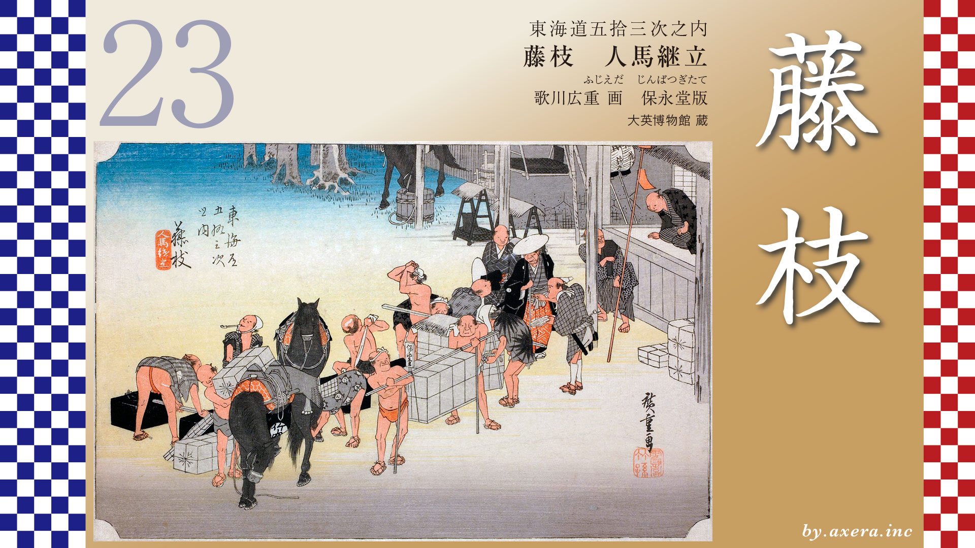
Okabe-juku, just beyond this point, was a small town, about 1.5 km from north to south and with a population of about 2,300, but it was located at the western entrance to the Utsunoya Pass, and thus was an important place to support the difficult crossing of the pass.
But now Okabe on The Tokaido? what’s? Where is that? It has become such a minor town. The reason for this becomes clear when you look at a wider area on Google MAP. The 400-meter-high mountain called Mankanbo on the left is on the sea side. In the Meiji era, the Tokaido railway line was originally planned to pass through Okabe-juku, but the route avoided the Utsunoya Pass, which is steep and a long way around, and instead passed through a tunnel from Yoso, beyond Mankanho, to Yaizu, at the mouth of the Seto River. In 1925, the Toso Railway from Fujieda opened to Okabe, but the line was discontinued after only 11 years, and the town of Okabe, a dead end with its back to the mountains, became even quieter.
This is the town of Okabe, now incorporated into Fujieda City. Okabe-juku on The Tokaido, which in the Edo period was the main street of the era, even if it had to face a steep mountain road, is now a very quiet town.
The Fujieda Bypass on National Route 1 has become a four-lane highway and passes the Utsunoya Pass in a flash through a tunnel, and the town of Okabe can be seen on the west side of the road, soon to be passed by.
The Yamauchi family, who ran the inn in this photo, Kashibaya, was one of the most prestigious families in Okabe-juku, which prospered in Okabe and held a prestigious position based on its wealth. The inn, which was built in 1836 and still remains today, is registered as a Tangible Cultural Property of Japan and is now a historical museum that provides visitors with a glimpse into the prosperity of that time.
After crossing the difficult Utsunoya Pass, The Tokaido becomes almost level from Okabe-juku and heads for Fujieda with a view of Suruga Bay in the distance.
コメント