
Fifty-three Stages of the Tokaido
Chiryu
Early Summer Horse Fair
Hoeido edition, painting by Utagawa Hiroshige
Minneapolis Institute of Art Collection
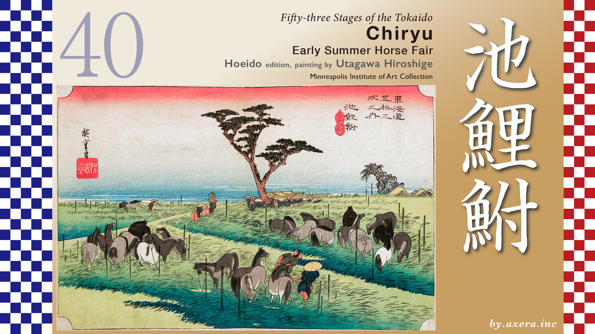
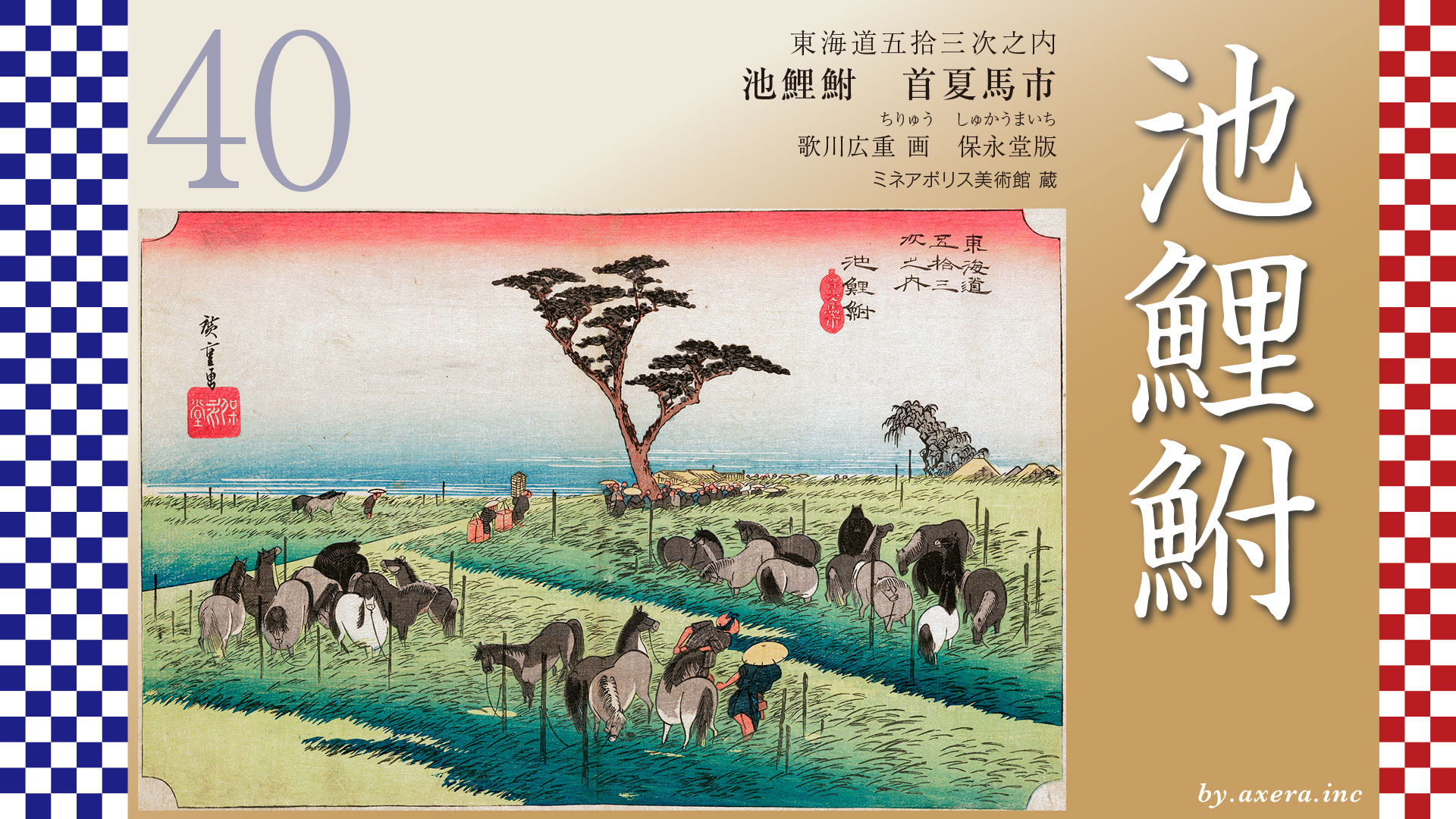
This image depicts the lively horse market that was held every summer in Chiryu.
Today, the name Chiryu is written with the characters meaning “to know” and “to stand.”
However, in the Edo period, when this town developed as a relay station on the Tokaido, it was written as Chiryu, meaning “pond, carp, and crucian carp.”
The origin of this name comes from a long, narrow pond nearby called Mitarai Pond.Fishing was forbidden there, allowing carp and crucian carp to thrive in great numbers.This distinctive landscape gave rise to the place name Chiryu, written with those characters.
Now, the distance from Okazaki-juku to Chiryu-juku was about 15 kilometers.
Even for Edo-period travelers, who often walked close to 40 kilometers a day, this was by no means a short journey.
Leaving Okazaki-juku, famous for its many winding turns, travelers crossed the Yahagi Bridge.
The Tokaido then followed the Yahagi River northward for a short distance before turning northwest.
Just ahead stood the Yahagi ichirizuka, a milestone mound marking distance along the road.
Continuing along what is now Route 1, one encounters the Ozaki pine avenue.
In the Mikawa region especially, many Edo-period pine-lined roads have been restored and preserved, allowing us to glimpse the appearance of the old Kaido.
After crossing the Sawatari River, the Raigoji ichirizuka could be seen standing on both the north and south sides of the road.
Passing today’s Ushida Interchange, another pine avenue begins.
This is known as the Chiryu Pine Avenue, which still stretches all the way to the eastern entrance of Chiryu-juku.
Beyond the underpass beneath Route 1 lies the eastern gateway to Chiryu-juku.
From here, the Tokaido turns off into a narrow road on the left, leading into the post town.
Let us now take a look at the Tokaido Bunken Ezu, an illustrated map of the Tokaido.
In the area around Chiryu, the scene of the horse market is clearly depicted.
On the right, we see the Raigoji ichirizuka and a pine avenue, followed by the village of Ushida.
Beyond that, the pine forest continues, and above it, the horse market is shown in progress.
If we assume this pine avenue corresponds to today’s Chiryu Pine Grove, the approximate location of the market becomes clear.
Looking again at the map, a blue circle marks the area where the horse market is thought to have been held.
The viewpoint of Utagawa Hiroshige is indicated with a red gradient.
Now, let us examine Hiroshige’s print more closely.
In the foreground, horses of various colors are tied to posts, waiting for auction.
The scene has a calm, pastoral atmosphere.
Beneath the large pine tree at the center, many people have gathered.
This tree is known as the Dango-matsu, or “Consultation Pine.”
Here, horse handlers selling the animals and horse traders buying them discussed prices and terms.
The building visible in the background is the horse market office, which oversaw the event.
At the time Hiroshige created this print, the Kariya Domain was responsible for its management.
To the left of the pine tree, two men carrying goods are likely delivering sake, food, or farm products to the office.
Farther left, we see a horse being led toward the Dango-matsu, perhaps after a deal has been agreed upon.
The Chiryu horse market also appears in the illustrated guide Tokaido Meisho Zue, and it is said that Hiroshige used it as a reference for this work.
The subtitle “Shuka Umaichi” means “Horse Market in Early Summer.”
Records of this market date back to before 1700.
Held from around April 25 for roughly ten days, it attracted as many as 400 to 500 horses and was said to be extremely lively.
In the Reisho edition, the scene shows a group of porters carrying luggage with illustrated tags “Efu”, which served as official government permits, as they enter Chiryu-juku from a road lined with pine trees.
In the Gyosho edition, travelers are shown resting beneath the pine trees at the western exit of the town.
The relay station of Chiryu can be seen in the distance to the left.
In the Poem edition, a procession presenting horses to the Imperial Court—known as the Hassaku Horse Offering—is shown entering the juku.
The print introduced here is actually a later printing.
Earlier impressions include a dark, whale-shaped mountain in the center background.
This mountain does not exist in reality, and for reasons unknown, it was removed in later editions.
Now, let us visit the site today.
Here is the Chiryu Pine Avenue, which still retains its beautiful appearance.
Traffic is relatively quiet now, as vehicles use the nearby bypass, though trucks are common due to the factories spread across the northern side.
At the end of the pine avenue stands a monument to the horse market.
Alongside an image by Hiroshige, it explains that this area once hosted the market.
According to the monument, this region had strong ties to horses as early as the beginning of the Kamakura period.
During the Edo period, it became a distribution center for cotton from Ise and Mikawa, transported by horse.
As a result, horse trading flourished, and Chiryu became widely known for its horse market.
While the exact location of the market remains uncertain, the area north of the monument is believed to have been its center.
This is the view of that area today.
Moving farther east, factories now line the road, but in the past, this land was likely open grassland for horses.
Here is an aerial view from Google Street View, looking down over the pine avenue.
Although the precise locations of the market and the Dango-matsu are unknown, the estimated area has been marked in red.
It is also said that a water channel once ran along one side of the pine avenue, allowing horses to drink.
From the Meiji period through the early Showa era, the market expanded to include not only horses, but also cattle and even mackerel.
However, around 1944, as World War II intensified, the market effectively came to an end.
A scene that had continued since the Edo period vanished abruptly because of war.
Thinking of this, one cannot help but feel a deep sense of loss.
Finally, let us look at the road from Chiryu-juku toward the next town, Narumi-juku.
The Tokaido winds repeatedly north of Chiryu Station, crosses the Aizuma River, and continues on toward Narumi.
In the distance, the cityscape of Nagoya comes into view.
コメント