
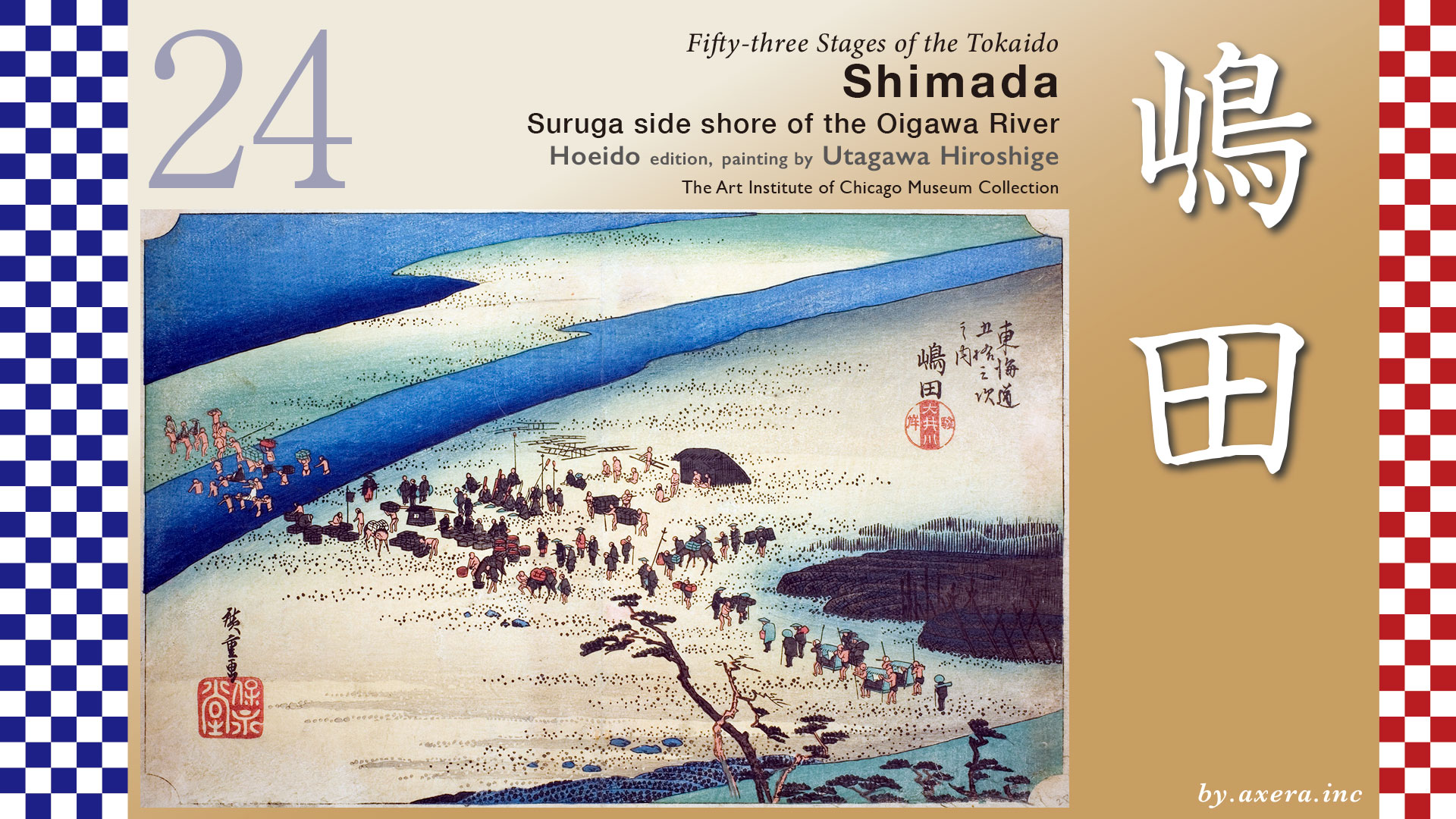
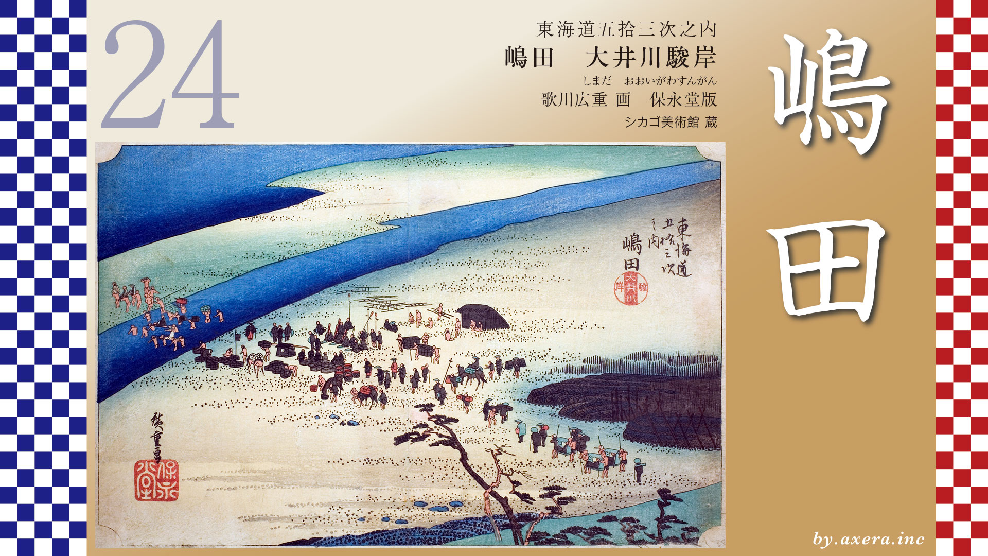
This painting is a view of river crossing scenery of the Oigawa River as seen from the Shimada-juku side.
First of all, please look at the Oigawa River on the wikimedia map.
The Oigawa River, represented by the blue line, originates at the 3,189-meter-high Ai-no-Take mountain range on the border between Shizuoka, Nagano, and Yamanashi prefectures and meanders through the rugged mountains of the Southern Alps. 1,280 square km of rainfall falls over its entire basin area, collecting at once in a fan-shaped area around Shimada before flowing into the sea. Therefore, in the Edo period , crossing this river from east to west was considered to be the most difficult part of The Tokaido.
It was about 8.7 km from Fujieda-juku to Shimada-juku, and another 2 km to the Oigawa River.
After leaving Fujieda-juku and crossing the Shida community, the road became a fork in the road with Tanuma-kaido at the Aoki area. If you go left, you can reach Omaezaki and the Sagara Clan. This is the home of Okitsugu Tanuma.
The Tokaido continues onward, parallel to the JR Tokaido Line, crossing the Tokojiya River.
Further on, cross the Otsuyagawa River, cross the Higashi-mitsuke, and enter Shimada-juku.
Enlarge the map. Hiroshige painted Shimada-juku and Kanaya-juku as “Suruga side shore of the Oigawa River” and “Toutoumi side shore of the Oigawa River,” respectively, in his Fifty-three Stages of The Tokaido. He drew the Oigawa River crossing separately in Suruga Province to the east and in Toutoumi Province to the west.
Now, beyond the honjin at Shimada-juku, near the Oigawa River, you will arrive at an area that recreates the river crossing facilities of the time. Here, as the Shimada-juku Oigawa Kawagoshi Site, you can see a museum, a river meeting place, inns, and objects reproducing the river crossing.
When you go out and look on the bank, it is quite a distance to the other side of the river, but in those days people used to walk across here.
In the Edo period, there was a similar over-the-river facility on the Kanaya side on the other side of the river, but today there is only a guide board.
Here you will find the Shimada-juku Oigawa Kawagoshi Ruins, which has been designated a national historic site. The Oigawa River was a large swift-flowing river with a width of approximately 1.3 km, according to records from the Edo period.
The shogunate forbade bridges and ferry crossings over the river, so when the water rose, the river was often blocked, or closed to traffic. When this happened, travelers on The Tokaido had no choice but to stay at Shimada-juku or Kanaya-juku and wait until conditions were such that they could cross. When the crossing of the Oigawa River was prohibited, passengers traveling from Edo to Kyoto would be stranded at Shimada-juku, and it is said that the inns in this area were sometimes extremely busy.
In 1696, the Shogunate established kawa-kaisho at Shimada and Kanaya on the Oigawa River. kawa-kaisho were places under the direct control of the magistrate of Edo, where the depth of the river was measured daily and reported to Edo via a tippet, and where administrative duties such as determining the rent for crossing the river and the order of crossing the river were performed. When the depth of the Oigawa River exceeded 1.5 meters, the river was completely closed.
Kawagoshi, a profession, was performed by professional Kawagoshi-ninsoku, and there were always 350 of them in Shimada and Kanaya, respectively, which was a stable occupation since they were lower-ranking officials directly under the domain government. By the end of the Edo period, the number of these people had swelled to about 600 each.
Travelers wishing to cross the Oi River first purchase a ticket called a kawafuda (river ticket) at a river crossing station. For each kawafuda, one person could be hired to cross the river.
The price of the ticket was determined by the depth and width of the Oigawa River, which was measured each morning, and the price was posted in front of the river crossing station. The price for one river tag was 48 Mons for the shallowest level of the river, known as the “crotch passage. Compared with craftsmen’s salaries at that time, it is about 2,400 yen today.
Since the ordinary water level of the Oigawa River is about 76 cm, a person called “tebari” was usually needed to assist the kawagoshi ninsoku workers, so at least two river tags were required.
This is the current view of the river from the bank on the Shimada side looking toward the Kanaya side. The time for crossing the river was from 6 a.m. to 6 p.m. Travelers would buy a kawafuda (river ticket) at the river crossing station and hand it to a kawagoshi-ninsoku, then ride on the his shoulders as they crossed the Oigawa River. The river tag was soaked in oil to make it waterproof, and the kawagoshi-ninsoku would tie the tag to a topknot or headband before crossing the river. After the crossing, the Kawagoshi-ninsoku would then take the kawafuda to the river crossing station, where it would be exchanged for cash.
This is called a palanquin stand, an object that allows you to take pictures of four human legs crossing the river for you. If a person were to cross the river with his chest up to his chest like this, he would have needed at least six river tickets, which would be about 20,000 yen in today’s terms.
This is a Daikouran-reidai palanquin stand for lords and others. This would require 32 river ticket, which is a tremendous amount of money. You can see that this river crossing was a major industry for Shimada and Kanaya at that time.
The longer the river stop was, the more people stayed, and Shimada became so crowded that it could easily be mistaken for Edo or Osaka. Furthermore, since many travelers pawned their kimonos during long stays to pay for their lodging, the distribution of kimonos and obis flourished in Shimada-juku. We heard an interesting story from an owner who still runs a kimono store in Shimada.
He said that because the city of Shimada has been enriched by river crossing for nearly 300 years, its economic sense has become a little off. The owner analyzed that there was no sense of crisis and no sense of taking the initiative to start something new in the entire town. The influence of this river crossing has continued to the present day, hasn’t it?
Hiroshige painted this over-the-river view from a slightly overhead view in great detail. The right side is the Shimada-juku side and the left side is Kanaya-juku, but the other side of the river is not depicted, perhaps to show the extent of the area.
The group of feudal lords is crossing the river at the head of the group. On the bank in the foreground, people dressed in haori are waiting for the procession to start. As expected of a procession of feudal lords, you can see that they are very heavily laden. The people depicted naked in the painting are almost exclusively Kawagoshi-ninsoku worker.
The ordinary traveler then crosses the ford and approaches the first sandbar. Painted in black on the right is the gabion. It is a gabion made of woven bamboo and filled with large stones, a material used for river improvement. Along with the gabion, there is also a “kawakura,” or “river cellar,” painted in black. Both gabion and kawagura were indispensable for river management of the Oigawa River, which was a raging river at that time.
A kawakura is a kind of flood fence constructed of wood to weaken the flow of water and prevent it from breaking.
See a reproduction of a kawakura and a gabion on it at a weir in Hamura on the Tama River.
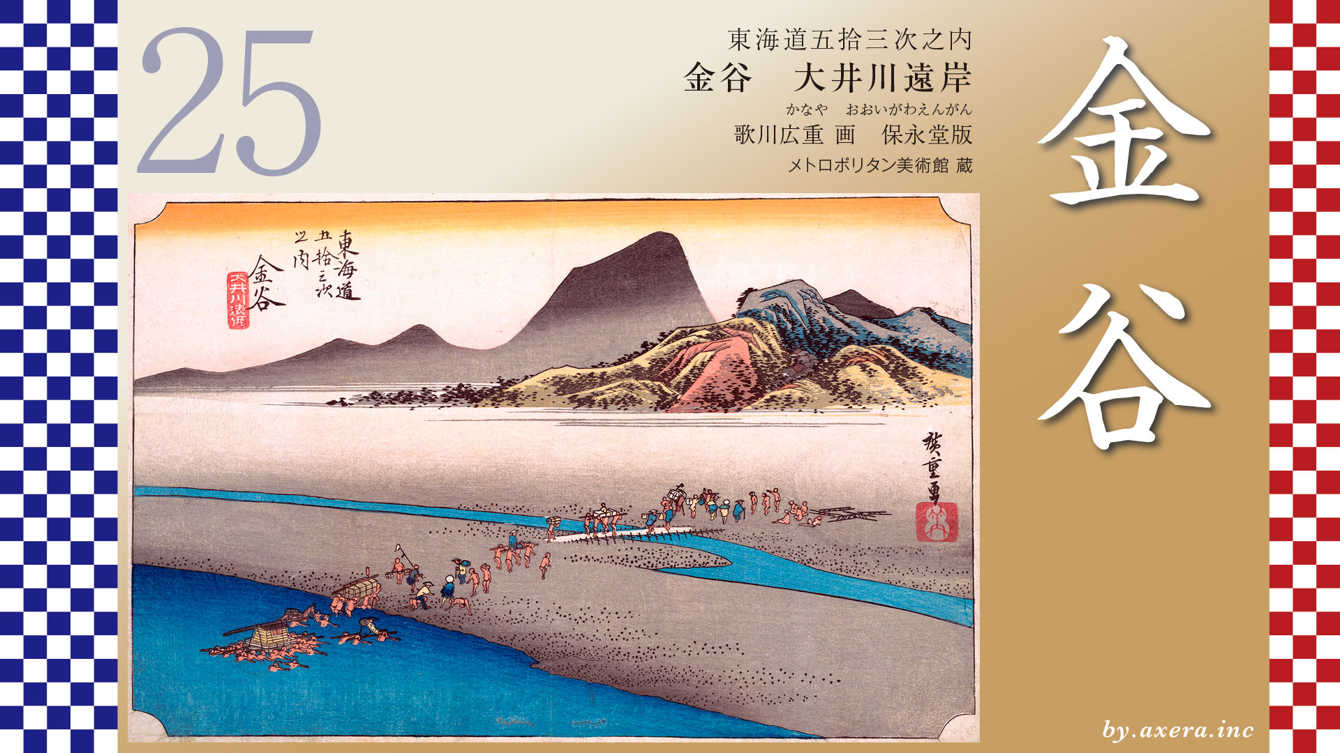
The Reisho edition on depicts a river crossing scene of wealthy people, as seen from the Kanaya side of the river. Various ways of crossing the river are depicted. You can also see Mt.Fuji.
Gosho editions are also painted looking at the Shimada side and Mt.Fuji. A simple bridge was built across the river to the sandbank, and travelers could walk to the bridge. At the far end of the bridge is the gabion with an empty palanquin stand in front of it.
Poem editin depicts the Daimyo’s procession crossing the river from the Kanaya side with Mt.Fuji. As one would expect, a lot of people are involved in the procession of feudal lords crossing the river. You can see that the budget of the time for the daimyo’s procession was enormous, and that it was spent in the local area.
Hokusai Katsushika’s Thirty-six Views of Mt. Fuji also depicts a river crossing and Mt. Fuji from the Kanaya side, with a river meeting place on the Shimada side at the far end. Unlike Hiroshige’s leisurely painting, this one depicts a more rhythmical and lively scene over the river. You can also see the tremendous number of gabion along the riverbank.
I actually went here. This photo is a view of the Kanaya side of the river, up to the water’s edge, which is now the mainstream. As you can see, the stream looks peaceful, but there are a frightening number of dams upstream and the levees have been strengthened. However, during the Edo period, the Shimada-juku itself and even The Tokaido were repeatedly damaged by the flooding of the Oigawa River.
Please also see the Google Street View looking toward Kanaya from Shimada side. The Tokaido is also included in orange.
Since the river was 1.3 km wide in the Edo period, it seems that the recorded width of the river was between the levee and a little wider than the levee, including the present riverbed.
See also Google Street View from downstream. This may be closer to the angle of Hiroshige’s painting.
During the Edo period, the Oigawa River flowed freely between these riverbanks according to its flow rate, sometimes overflowing and pouring into the sea.
Traditionally, the Shogunate forbade the building of bridges mainly for defensive reasons to protect Edo, but recent research has shown that the Oigawa River was apparently unsuitable for bridges and ferry crossings because of its high water volume and rapid flow before the Edo period. So the Oigawa River was a huge uncontrollable river.
On the other hand, in 1838, six temporary bridges were built across the sandbar from the area in this photo to the mouth of the river, and records show that travelers were secretly ferried across the river for a low toll.
In any case, this raging river flowing from the distant Southern Alps gave birth to a major industry in the Edo period, called “kawagoshi,” in this area, which brought a tremendous economic effect to both banks of this river. This painting by Hiroshige shows how prosperous it was.
コメント