
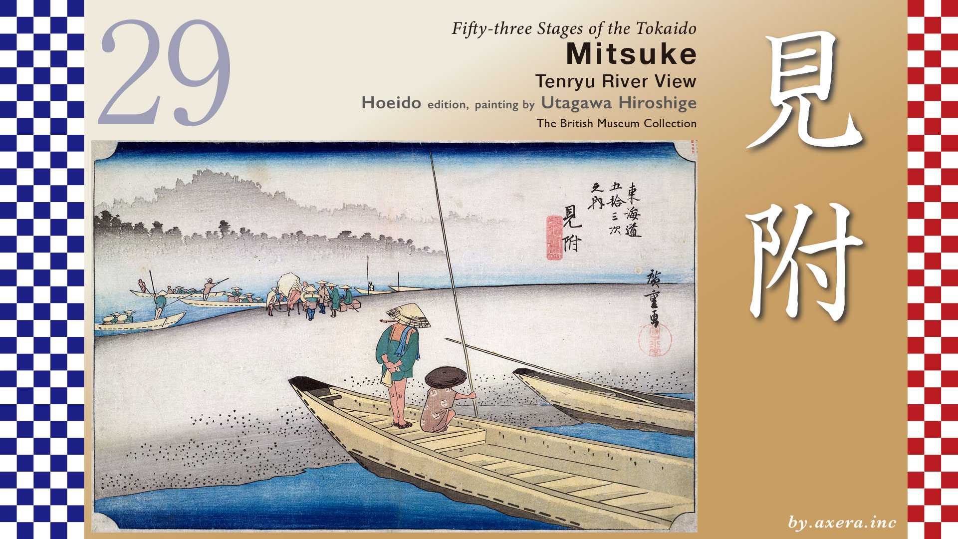
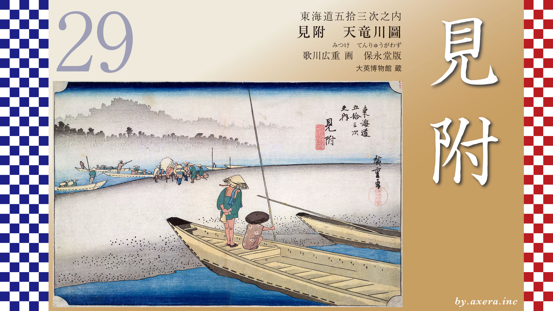
Fifty-three Stages of the Tokaido
Mitsuke
Tenryu River View
Hoeido edition, painting by Utagawa Hiroshige
The British Museum Collection
This depicts the scene of a river crossing by boat on the Tenryu River, which lies between Mitsuke-juku and Hamamatsu-juku.
The distance from Fukuroi-juku to Mitsuke-juku is about 5.9 km, but to reach the Tenryu River depicted by Hiroshige, one had to travel another 7 km further west. First, please see the route between the relay stations.
After passing through Fukuroi-juku on the Tokaido, you will soon come upon the Kihara Ichirizuka, restored to its original size.
Continuing further west, you cross the Ota River and climb the small hill where the ancient battlefield of Dainichido lies.
Continuing further west, beyond the Akiha Mountain night beacon, lies the signpost for Mitsuke-juku. Formally, the area beyond this point constitutes Mitsuke-juku.
After passing the honjin in Mitsuke-juku, the Tokaido turns left just before crossing the river, heading toward what is now Iwata Station and passing by the ruins of the Totomi Kokubunji along the way.
If one continued straight ahead instead of turning at the honjin, they could take the shortest route to the Tenryu River ferry crossing, known as the Ikeda Shortcut or Hime-kaido. However, this path was a narrow mountain trail difficult for palanquins, horses, and luggage to traverse. Therefore, the official main route remained the Tokaido, which descended southward.
Traveling along the Tokaido road near the Tenryu River, there was a Tateba called Nagamori. Here, a famous ointment called “Nagamori Kouyaku” was sold, effective for chapped skin and cuts, and it was very popular.
On the other hand, taking the Hime Kaido road marked by the green line allowed one to pass through the ancient battlefield known as Hitokoto-zaka, significantly shortening the distance to the ferry crossing at Ikeda Village.
At this Hitokoto-zaka slope, in 1572, a battle took place between Takeda Shingen, who invaded from Kai Province, and the 31-year-old Tokugawa Ieyasu, lord of Totomi Province. Thanks to the valiant efforts of Honda Tadakatsu, the Tokugawa forces were able to retreat safely to Hamamatsu. The following year, at the famous Battle of Mikatagahara, the allied forces of Tokugawa and Oda Nobunaga were also soundly defeated by the Takeda army.
Here, please look at this map from the Meiji period by the Geospatial Information Authority of Japan.
In connection with these battles, Tokugawa Ieyasu guaranteed the residents of Ikeda Village, who had consistently supported the Tokugawa forces, the right to operate the ferry across the Tenryu River. Consequently, Ikeda Village held the exclusive right to operate the Tenryu River ferry until the end of the Edo period and obtained the right to collect part of the operating costs from the province of Totomi. For this reason, the Tenryu River ferry was also known by the alternate name “Ikeda Ferry.”
Please note the green line on the map. Before the Edo period, the road serving as an alternative to the Tokaido along the Pacific coast was this Kamakura-Kaido. At that time, the roads leading from various regions to Kamakura, where the Kamakura Shogunate was located, were collectively called the Kamakura Kaido. In this area, it was called the Kyo-Kamakura Okan or the Kamakura-kaido. During the Heian period, ferry services across the Tenryu River became commonplace, and the village of Ikeda on its west bank thrived.
Later, during the Edo period, kaido improvements were made, and the Tokaido was rerouted southward to accommodate carts and the sankin-kotai system, bypassing the old Kamakura-kaido. That’s the indigo-colored road. The green-colored old Kamakura-kaido, along with the kaido beyond it, was collectively called the Hime-kaido.
Please refer to the wide-area map here. The green Hime kaido, after crossing the Tenryu River, could proceed straight westward to pass through the northern side of Lake Hamana.
This route was called the Hime-kaido because it bypassed the strict checkpoint at Araino-seki-gate, famous for its “Enter the gun and leave the woman,” passing through Kiga and Mikkabi instead, and connecting to Goyu via the Honzaka Pass.
“Enter the gun and leave the woman,” refers to the strict regulations imposed by the Edo shogunate to prevent rebellion. These regulations targeted “firearms and other weapons entering Edo” and “daimyo wives and women leaving Edo” at checkpoints. The purpose was to prevent uprisings caused by smuggled weapons and to prevent the escape of daimyo wives and women, who served as hostages.
The Tenryu River ferry crossings were located in Ikeda Village and Nakanomachi Village on the opposite bank. However, during the Edo period, Ikeda’s ferry crossings were at three locations―upper, middle, and lower―depending on the river’s conditions. Since the state of the sandbars and river width on this map likely resembles that of the Edo period, I have recreated the positions of the three ferry crossings with dashed lines. Furthermore, I have added a red gradient to the area where Hiroshige’s viewpoint is likely situated.
Next, please view the Wikimedia map and Google Street View. The Tenryu River originates from Lake Suwa in Nagano Prefecture and flows approximately 213 km before emptying into the Enshu Coast.
The Tenryu River, also known as the “Wild Tenryu,” has long been a notorious hazard, requiring ferry crossings for ages. The reason was its extremely swift currents―so strong that crossing on foot was impossible, much like the Oi River. At its farthest reaches, you can see Lake Suwa, the river’s source.
Now take a look at Apple’s Street View. Originally, the Tenryu River’s key alluvial fan area was around Futamata, where the river water flowed like a network across the southern plains. Over time, due to the river’s sedimentation and the influence of the terrain, the flow toward Mitsuke became the main channel rather than the one toward Hamamatsu. Subsequently, the Tenryu River split into two major streams: the Magome River, known as the Little Tenryu, and the present-day Tenryu River, known as the Great Tenryu.
Originally, the Tenryu River flowed freely through the light blue area shown on the map, bringing various floods and fertile soil and sand to this region. One trace of this is the Nakasimada Sand Dunes. In 1675, the Hikosuke Embankment, located upstream on the Magome River―then considered the main channel of the Tenryu River and known as the Aratama River―was constructed. This effectively separated the rivers, establishing the Magome River and Tenryu River into their present-day forms.
Please view Hiroshige’s painting with this history of the Tenryu River in mind.
The Tenryu River had multiple channels and large sandbars. The two boats in the foreground belong to boatmen on the narrower channel on the Ikeda side. One, holding a pipe, waits for passengers to transfer over from the wider channel on the Nakano-machi side. Notice the river mist shrouding the background.
According to late Edo period records, during low water, the total width of the Tenryu River was about 800 meters. The Ikeda side channel was 18 meters wide, the Nakano-machi side channel was 45 meters wide, and in the middle lay a vast sandbar of gravel and sand.
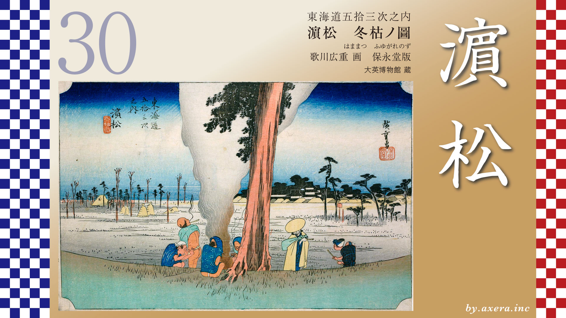
Around 1710, the standard fare for crossing the Tenryu River was 12 mon per traveler. Since they crossed the river twice, they paid double that amount, 24 mon. Comparing this to the wages of craftsmen at the time, with 1 mon equaling about 50 yen, that would be roughly 1,200 yen.
On the sandbar, there is one horse carrying a load. At that time, the ferry fee for a horse was 36 mon, and for the load, 30 mon. Since each had to be ferried twice, the total cost was double, 66 mon. There was no other way to cross the Tenryu River besides by boat, so there was no choice.
Incidentally, this print by Hiroshige is not a first print but a second.
The print, extremely close to the first print, bears black horizontal lines printed as guides for the printer’s blurring technique. It seems the coordination between Hiroshige, the engraver, and the printer wasn’t quite right, but the scene of the river mist has a certain atmosphere, doesn’t it?
The second print technique achieves a better balance in the gradient and creates a more appealing atmosphere, doesn’t it?
The Reisho edition depicts a grand, distant view of the ferry crossing. Upon closer inspection, you can see that the sandbar was permanently land-connected enough for pine trees to grow tall.
The Gyosho edition depicts a composition where ferries pass each other in the distance. The contrast between the passengers’ expressions aboard the boats and the boatmen standing at the railings steering their vessels is quite interesting.
The poem edition depicts horses loaded with sorted cargo descending to the ferry crossing on the Tenryu River.
I actually went there myself. While the riverbed is being utilized quite extensively, please check the four locations captured in Google Street View from above.
This is the stone monument marking the site of the Tenryu Ferry Crossing outside the levee.
This is the view of the river from the top of the levee. The riverbed, where water doesn’t usually flow, has been developed into parking lots and jogging paths.
This is the view after passing the riverbed, reaching close to the water’s edge. You can see a natural levee has formed in the foreground, and beyond it lies a fairly extensive sandbar.
This is the view beyond the levee. Even though the water flow is controlled upstream, you can see the Tenryu River rushing by in quite a swift current.
Perhaps raising your viewpoint slightly would help you appreciate the atmosphere of Hiroshige’s painting.
Today, numerous bridges―including rail and highway bridges―span this once-turbulent river, allowing constant passage to the opposite bank. Above all, this wide, dry riverbed speaks to the success of flood control efforts. However, it seems this was taken just after a dam release, and seeing the entire Tenryu River on Google Maps looking murky blue is rather sad.
Upstream on the Tenryu River, numerous dams―including the Sakuma Dam, where sand has filled 30% of its storage capacity―and countless erosion control dams hold back the various materials flowing down the Tenryu River, thereby maintaining flood control downstream.
On the other hand, sandy beaches like the Nakatajima Dunes and the Enshu Coast, where sand supply has now ceased, are being steadily eroded. We have reached a point where we must artificially halt the flow of sand using breakwaters and similar structures.
Looking once more at Hiroshige’s paintings, where a relaxed atmosphere flows, I can’t help but wonder if, through large-scale flood control projects, we haven’t left something important behind upstream.
Continue viewing ahead with Google Street View. The Tokaido crosses the blue-tinted Tenryu River, passes under Route 1, and heads toward Hamamatsu-juku, located beside the Magome River, once called the Little Tenryu.
コメント