
Fifty-three Stages of the Tokaido
Futagawa
Sarugababa Plateau
Hoeido edition, painting by Utagawa Hiroshige
The Art Institute of Chicago Museum Collection
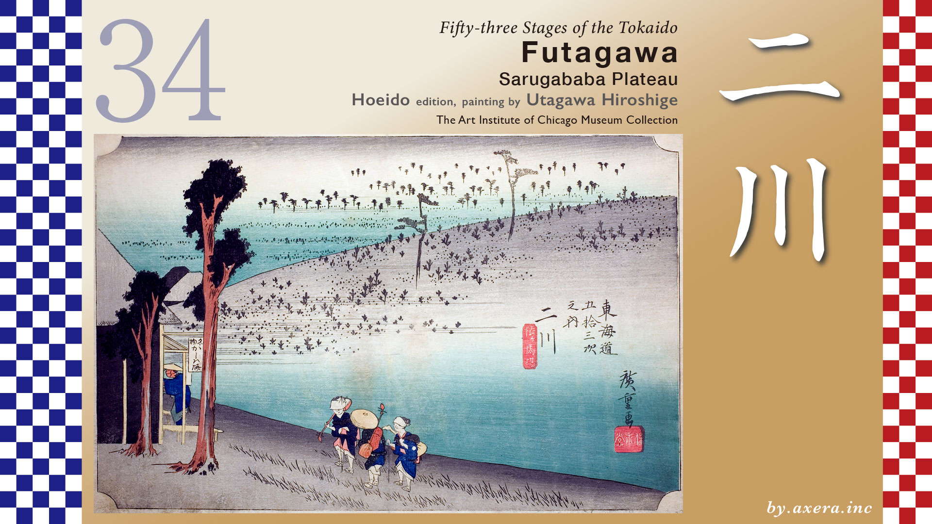
This depicts a tea shop selling the famous kashiwa mochi on a hill called Sarugabamba.
The distance from Shirasuka-juku to Futagawa-juku is about 5.7 km, but even during the Edo period, the road between them was apparently almost completely devoid of anything along the way.
Leaving Shirasuka-juku, you soon cross a small river called the Sakai River. This river served as the border, marking the entry from Totomi Province into Mikawa Province. It still forms the border between Shizuoka Prefecture and Aichi Prefecture today. This is represented by the light blue dotted line.
A little further on, it merges with National Route 1, and from here onward, the road continues alongside fields and factories.
Soon the retaining wall of the Shinkansen will come into view on your right, but the Tokaido road of the Edo period crossed the Shinkansen diagonally.
Crossing the Shinkansen and then the JR Tokaido Line, you reach Futagawa-juku, where a Ichirizuka milestone stood.
Here we examine Hiroshige’s painting in detail.
The location named “Sarugabamba” in the subtitle, also known as “Sarubamba,” was renowned as a scenic spot for soft pine trees. In the painting, countless soft pine are depicted across the gentle hills stretching into the distance.
The signboard at the tea shop on the left reads “Famous Kashiwa Mochi,” and a traveler has just stopped by. From the right foreground, three blind female musicians are climbing the slope toward the tea shop. These blind female musicians, known as gozu, traveled the country carrying shamisen and kokyu, performing joruri and songs under the eaves of houses.
Regarding this famous kashiwa mochi, an anecdote associated with Toyotomi Hideyoshi is passed down. While en route to the Odawara Campaign, Hideyoshi enjoyed mochi containing sago palm seeds offered by an elderly couple at a teahouse. After achieving victory in battle, he ordered it to be called “kachiwa mochi” (Victory Harmony Mochi). Furthermore, because the old woman’s face was deeply wrinkled, people called her “Saru ga Baba” (Monkey Old Woman). This name became confused with the local place name “Sarugabamba,” and thus the famous “Sarugabamba Kashiwa Mochi” was born.
Even in the Reisho edition, travelers are depicted resting at a tea shop selling “Kashiwa Mochi” rice cakes or changing palanquin. In the distant background at the center, what appears to be a village is also depicted. However, records indicate there were no houses around Sarugabamba; only a solitary, poorly constructed tea shop run by an elderly couple seems to have stood there.
Even in the Gyosho edition, the angle differs, but it still depicts the famous tea shop selling “Kashiwa Mochi” rice cakes and villagers working nearby. The hill in the background also shows the scenic spot, soft pine trees hill. However, in reality, it seems only an elderly couple from Sakai-juku Village, about 200 meters to the north, came during the daytime to sell hot tea, dumplings, and waraji sandals to travelers going up and down the Tokaido Road.
The Poem edition depicts the entrance to Futagawa-juku as rain begins to fall, marked by the landmark post. The torii gate on the left belongs to Futagawa Hachimangu Shrine, which enshrines a deity transferred from Tsurugaoka Hachimangu in Kamakura.
Now, regarding the location of this teahouse, I searched the Futagawa-juku area but found no place called Sarugabamba. Upon closely examining old pictorial maps, however, I discovered something unexpected. The place called Sarugabamba was described not in Futagawa, but rather just outside the previous post station, Shirasuka-juku.
I’ve marked this red circle on the pictorial map depicting the Tokaido. The sign-like mark on the far right is a official bulletin board notice indicating the end of the post station. That means it’s the edge of Shirasuka-juku. Below and to the left of it, it says “Famous Kashiwa Mochi” and “Sarugabamba,” so this area seems to be the setting of the painting. To the left of that, it depicts the Sakai River. This means this teahouse was located between the border of Mikawa Province and Totomi Province and the western edge of Shirasuka-juku.
Furthermore, there is also a record stating “no houses between here and Futagawa” around the area beyond the Sakai River, so it seems there were no tea shops or the like.
I also found a written description of Sarugabamba in the Tokaido Meisho Zue. It’s within the red frame. It states that traveling east of the Sakai River, one sees many pine trees on both sides, creating an elegant atmosphere, and that kashiwa-mochi from the tea shop at Sarugabamba is a famous specialty. Looking into address records, I also found that “Sarugabamba” existed as an old place name in Kosai City, specifically as a district name within Sakai-juku.
Please take another look at the current map. The vertical light blue dashed line represents the Sakai River, which was the border at that time. The area where the Tokaido road curves marks the western edge of Shirasuka-juku. The area northwest of that is Sarugabamba, and beyond that lies Sakai-juku Village.
I added the orange Tokaido route to Google Street View around this area. This should give you a rough idea of where Sarugabamba is located.
Hiroshige didn’t seem to grasp this spatial relationship very well, but I’ve added a red gradient to indicate what I believe was his viewpoint. The elderly couple running the kashiwa-mochi shop apparently traveled from Sakai-juku Village, slightly north of Sarugabamba, to their shop near this red viewpoint along the Tokaido. This Sakai-juku Village was a supplementary village within the relay station system called a “kashuku,” supporting Shirasuka-juku with manpower and horses.
I actually visited this place. What was once an empty field is now filled with houses and farmland, and the image of a small hill has faded. It’s believed that the entire area around here was once planted with soft pine trees.
Before Hiroshige published his Fifty-three Stations, Katsushika Hokusai’s Tokaido woodblock depicting Shirasuka featured a couple making kashiwa mochi as a local specialty. It really was a famous local treat around here.
Furthermore, the Poem edition of Shirasuka written by Hiroshige, which I introduced last time, featured a poem praising the kashiwa mochi at Sarugabamba. It seems that teahouse was indeed one that sold kashiwa mochi. Though it wasn’t actually a place with a view of the sea.
The “Kachiwa Mochi” rice cakes filled with the fruit of the sago palm, named by Hideyoshi, became famous precisely because their taste was so peculiar. Various Edo-period yellow-covered books and travelogues humorously describe the taste of these kashiwa mochi. In one such yellow-covered book by Jippensha Ikku, they appear as a food laced with poison―perhaps a playful jab at the strange flavor of these kashiwa mochi.
Shirasuka is also said to be the birthplace of “Kashiwa Mochi” rice cakes. While there are records of modern-day bakeries in Shirasuka, traditional Japanese confectionery shops in Washizu, and Toyohashi making this “Kashiwa Mochi” for events and selling it temporarily, it seems you can’t buy and taste it anymore. I really wish I could have tasted that original kashiwa mochi with its sago palm flavor.
Hiroshige traveled the Tokaido to Kyoto in the summer of 1832, at the age of 36, at the request of the shogunate. This is an original painting from that journey. The first series of fifty-three stations published by Hoeido followed shortly thereafter and became immensely popular.
However, I suspect that during this journey, they may have bypassed this section of the Tokaido and instead used the Himekaido. Therefore, I believe Hiroshige did not actually see the scenery himself, and the paintings of the route they did not take ended up depicting fundamentally incorrect landscapes.
Now, please take a look at Google Maps from Futagawa-juku onward. While National Route 1 and Tateiwa Kaido are now the main streets of Futagawa town, remnants such as the Honjin Museum and merchant houses remain along the Tokaido route, allowing you to glimpse what it was like back then.
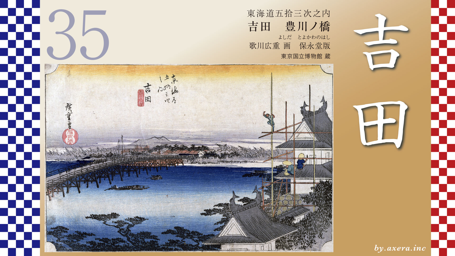
The Tokaido crosses the Tateiwa Kaido and, skirting around Iwaya Kannon, finally heads toward Yoshida-juku. Mikawa Bay can be seen in the distance.
コメント