
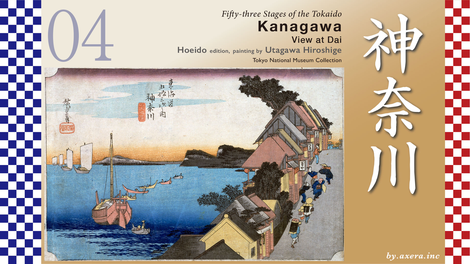
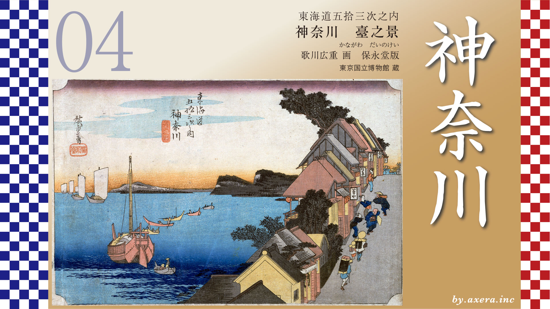
This is a view of the sea from a scenic hill called “Dai”, which was located on the north side of what is now the west exit of Yokohama Station.
The Tokaido Highway runs for about 10 kilometers from Kawasaki Juku to Kanagawa Juku. After leaving Kawasaki Juku, the road goes through Hacchonawate station, and then proceeds in a southwesterly direction along the road between the JR tracks and Daiichi Keihin.
On the way, you will pass over the first Ichirizuka after leaving Edo, and cross the Tsurumi Bridge, a magnificent bridge for its time, which spans the Tsurumi River. Beyond that, you will pass Tsurumi Shrine and Sojiji Temple, and turn gently to the right.
Around the confluence with Daiichi Keihin, there is a highway running above, a monument to the Namamugi Incident, and next to it, Japan’s first beer factory. The Tokaido continues with the Daiichi Keihin for some distance, and the eastern end of Kanagawa-juku is around the Kanagawa Shinmachi Station of the Keikyu Railway.
Eventually, before crossing the Taki no Hashi bridge, there is a Honjin, and this area is the center of Kanagawa-juku.
The Tokaido then turns gently to the right and slowly climbs up the hill around Aoki, approaching the location depicted by Hiroshige. Today, it is impossible to go straight ahead due to the Aoki Bridge and the railroad, but in the Edo period, the Tokaido was able to go straight ahead. In those days, it passed in front of the gate of Hongakuji Temple, which was larger than today’s Hongakuji Temple.
After passing this point, you will enter an area where there is a forest of teahouses called “Dai”. Hiroshige painted the view from this area. The viewpoint is shown in red gradation.
Beyond that point, the slope gradually descends, and the western end of the Kanagawa-Juku is located at the west exit of what is now Yokohama Station, around Tsuruya-cho.
Now, please look at the GSI map with Tokaido drawn in dark blue.
This is covered by a map from around 1881, which shows what we can imagine the Edo period to be like.
In addition, I have made the area that would have been the sea in the Edo period light blue, and the Kanagawa-juku area is represented by a green line, and I have included Hiroshige’s point of view.
If we put the map back to the modern map as it is, we can see that the Tokaido around Kanagawa-juku almost faces the sea, and from Hiroshige’s viewpoint, the sea could be seen clearly.
Here, please take a look at a travel guide-like map depicting the Kanagawa-juku in 1824. First, a bird’s-eye view of the entire Kanagawa-juku, as if it were drawn from the previous map.
The area around the red dotted line is Dai town. Overlooking the sea to the east and overlooking an inlet called Sodegaura bay, it was known as one of the most scenic spots on the Tokaido. Kanagawa-juku was nearly 4 km long, with a population of approximately 5,800, one honjin, 58 inns, and 1,300 inns and houses lining both sides of the road.
This is a detailed drawing of the area that Hiroshige painted. You can see that the Tokaido passes in front of Hongakuji Temple, which has extensive grounds. Here, too, Hiroshige’s viewpoint is shown in red gradation.
Please see a more clear picture drawn by Edo Meisho Zue, a picture of six pieces connected together. The Tokaido runs westward from the gate of Hongakuji Temple. Depicted on the last page are the Dai-no Chaya-gai and Kanagawa Minato, and the sea to the left is Sodegaura bay.
Kanagawa Minato was opened in the Kamakura period and was a strategic point for water transportation of people and goods. 1858 was the year of the Japan-U.S. Treaty of Amity and Commerce, which included the port.
Let’s take a closer look at Hiroshige’s painting.
This area called “Dai”, painted by Hiroshige, was a very popular place with a row of teahouses overlooking the sea from a pier jutting out into the ocean. The sea occupying almost the entire left side is Sodegaura bay, and below in the foreground is Kanagawa Port. Offshore, benzai boats with their sails raised are rhythmically lined up, and in the foreground is a bensai boat with its sails lowered, with several fishermen’s boats around it. The mountains behind those sailboats are the mountains of Boso, and to their right are the mountains of Yamate and Noge.
To the right, on the seaward side of the Tokaido, tea stalls are lined up in rows, and women waiting for customers are trying to attract travelers. Behind them, a father and son in oizuri, white pilgrim robes, and a traveler carrying a Zushi are passing by as if nothing had happened.
The travelers carrying the Zushi of the principal image of Buddha are monks called Rokubu-sama, who are on a journey to copy the Lotus Sutra and deposit it in 66 sacred places. They were dressed in white hoods and tin cans, etc., and were visiting houses to receive food, etc., on a rigorous journey of ascetic practice to attain enlightenment.
The painting we have adopted this time is almost the first print, but it is not in very good condition. However, compared to the later prints, I feel that I can better understand Hiroshige’s intentions.
The contrast between the secular traveler who is invited by the unauthorized innkeeper and the traveler who is placed in training is very interesting.
There is also an alternate view, but the overall composition is different. The piles to protect against waves are visible in the ocean, the sky is much wider, and the position and color of the clouds are different. However, the signboards of the teahouses are easier to read, and from the foreground, you can read Yoshiya, Taruya, Tamagawa, and Sakuraya.
The original painting that Hiroshige used as a reference for this painting is Edo Meisho Zue.
In it, “Sakuraya” is depicted on the far right as a very large store. This store has changed its name and is still in business today.
The Reisho edition depicts the chaya district in Dai from a little to the west, along with the sea. Again, the name Sakuraya is visible. The expanse of the sea at the back is quite emphasized.
The Gyosho edition is an image looking back at the teahouse district in Dai-no-chaya from Sengen-shita, a little further down the Tokaido. You can see that the cliff side of the teahouse has been pierced with pillars. The comparison between the the peddlers and the travelers is typical of Hiroshige.
The Poem edition depicts a view of the area down the teahouse street. Yamate and the mountains of Noge are depicted in the same way. Children are also playing in front of the teahouse on the right.
Please also see Hokusai’s 53 Stages. A woman traveling alone is looking out of the window of an inn at the sea and sparrows in Sodegaura bay. This is a Hokusai painting with a good sense of romanticism.
I have actually been here.
The angle of the slope is different, but Hiroshige probably painted the view from approximately this area. The sea is not visible at all.
A little further down the street, on the left, is the restaurant depicted in Hiroshige’s painting as Sakuraya, which is still in business today, though it has changed its name to Kappou Tanakaya.
At one time, Ryoma Sakamoto’s wife, Oryo, worked at this “Sakuraya,” and Shinsaku Takasugi and the American consul, Harris, were also frequent visitors.
Oryo, whose real name was Ryo Narasaki, was a very intelligent woman who liked to drink, was very amiable, and was very good with customers, making her stand out from the countless other waitresses of the time. She was very studious, spoke English, and was well versed in foreign affairs, so she may have met Consul Harris as well.
In Google MAP, I drew the orange Tokaido from above the area of the Tanakaya. It is hard to tell what is what because there are so many buildings in a row.
Therefore, I covered the area that was then the sea with light blue. You can see that the Tokaido is making a big curve along Sodegaura bay. I am amazed that the scenic Sodegaura bay has turned into such a mess in just less than 200 years. Furthermore, you have learned that the center of Kanagawa, which is now the name of the prefecture, was not Yokohama, but around Kanagawa-juku.
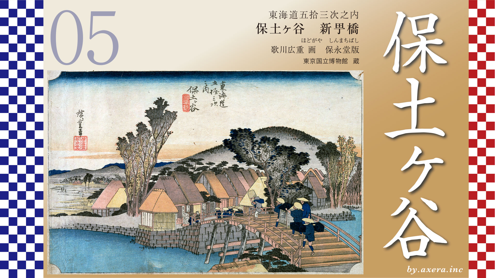
From here, the Tokaido Highway curves to the left toward Mt. Fuji, then passes under Sengen-shita and heads toward Hodogaya-juku.
コメント